Cloverland, Indiana
Cloverland is an unincorporated community in Posey Township, Clay County, Indiana. It is part of the Terre Haute Metropolitan Statistical Area.
Cloverland | |
|---|---|
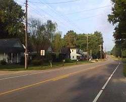 Cloverland, Indiana, along State Road 340 | |
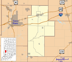 Cloverland Location in Clay County | |
| Coordinates: 39°30′05″N 87°13′53″W | |
| Country | United States |
| State | Indiana |
| County | Clay |
| Township | Posey |
| Elevation | 607 ft (185 m) |
| ZIP code | 47834 |
| FIPS code | 18-13888[1] |
| GNIS feature ID | 432691[2] |
Geography
Cloverland is located at 39°30′05″N 87°13′53″W, about six miles west of the county seat, Brazil, and less than one mile east of the Vigo-Clay line. Cloverland is within the humid continental climate zone. The terrain is gently rolling and includes a small brook.
History
The town was platted in 1834 as a speculative venture by Terre Haute doctor Charles Modesitt. The town grew steadily with several general stores, a carpentry shop, and several other ventures. With the construction of the railroad, business activity shifted to nearby Brazil, and the town's population dwindled.[3] A post office was established at Cloverland in 1850, and remained in operation until it was discontinued in 1920.[4] Today, a church, a commercial building, and cluster of houses are all that remain.
References
- "U.S. Census website". United States Census Bureau. Retrieved 2008-01-31.
- "Cloverland, Indiana". Geographic Names Information System. United States Geological Survey. Retrieved 2009-10-10.
- Blanchard, Charles (1884). Counties of Clay and Owen, Indiana: Historical and Biographical. F.A. Battey & Company. pp. 221.
- "Clay County". Jim Forte Postal History. Archived from the original on 3 September 2014. Retrieved 30 August 2014.
Municipalities and communities of Clay County, Indiana, United States | ||
|---|---|---|
| City | Map of Indiana highlighting Clay County | |
| Towns | ||
| Townships | ||
| CDP | ||
| Other unincorporated communities |
| |
| Ghost towns | ||
| Footnotes | ‡This populated place also has portions in an adjacent county or counties | |
| Authority control |
|
|---|