History of Djibouti
Djibouti is a country in the Horn of Africa. It is bordered by Somalia to the southeast, Eritrea and the Red Sea to the north and northeast, Ethiopia to the west and south, and the Gulf of Aden to the east.
Part of a series on the |
|---|
| History of Djibouti |
 |
| Prehistory |
| Antiquity |
|
| Middle Ages |
|
| Colonial period |
|
| Modern period |
| Republic of Djibouti |
|
|
In antiquity, the territory was part of the Land of Punt. The Djibouti area, along with other localities in the Horn region, was later the seat of the medieval Adal and Ifat Sultanates. In the late 19th century, the colony of French Somaliland was established following treaties signed by the ruling Somali and Afar Sultans with the French. It was subsequently renamed to the French Territory of the Afars and the Issas in 1967. A decade later, the Djiboutian people voted for independence, officially marking the establishment of the Republic of Djibouti.
Prehistory
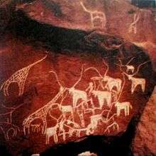
The Djibouti area has been inhabited since at least the Neolithic 12,000 years ago. Pottery predating the mid-2nd millennium BC has been found at Asa Koma, an inland lake area on the Gobaad Plain. The site's ware is characterized by punctate and incision geometric designs, which bear a similarity to the Sabir culture phase 1 ceramics from Ma'layba in Southern Arabia.[1] Long-horned humpless cattle bones have also been discovered at Asa Koma, suggesting that domesticated cattle was present by around 3,500 years ago.[2] Rock art of what appear to be antelopes and a giraffe are likewise found at Dorra and Balho.[3] A team of archaeologists discovered funds stone houses, the walls of a rectangular edifice with orienteer recess to Mecca. They have also updated shards of ceramics, chipped stone tools and a glass bead. The oldest engravings discovered to date are from the fourth or third millennium BC in the pre-Islamic period, the most famous is the site of Handoga there where the ruins of a village squares subcircular dry stone delivered different objects. An old settlement, Handoga is the site of numerous ancient ruins and buildings, many of obscure origins, including ceramic shards, matching vases used brazier , containers that can hold water, several choppers and microliths, blades, drills, trenchers basalt, rhyolite or obsidian. A team of archaeologists discovered an elephant 1.6 million years BC near the area. They also found a pearl orange coralline, three glass paste , but there were no metal objects discovered.
Antiquity
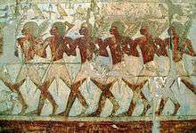
Together with northern Somalia, Eritrea and the Red Sea coast of Sudan, Djibouti is considered the most likely location of the land known to the ancient Egyptians as Punt (or "Ta Netjeru", meaning "God's Land"). The old territory's first mention dates to the 25th century BC.[4] The Puntites were a nation of people that had close relations with Ancient Egypt during the times of Pharaoh Sahure of the fifth dynasty and Queen Hatshepsut of the eighteenth dynasty. They "traded not only in their own produce of incense, ebony and short-horned cattle, but also in goods from other neighbouring regions, including gold, ivory and animal skins."[5] According to the temple reliefs at Deir el-Bahari, the Land of Punt at the time of Hatshepsut was ruled by King Parahu and Queen Ati.[6]
Macrobians
The Macrobians (Μακροβίοι) were a legendary people and kingdom positioned in the Horn of Africa mentioned by Herodotus. Later authors (such as Pliny on the authority of Ctesias' Indika) place them in India instead. It is one of the legendary peoples postulated at the extremity of the known world (from the perspective of the Greeks), in this case in the extreme south, contrasting with the Hyperboreans in the extreme east.
Their name is due to their legendary longevity; an average person supposedly living to the age of 120.[7] They were said to be the "tallest and handsomest of all men".[8]
According to Herodotus' account, the Persian Emperor Cambyses II upon his conquest of Egypt (525 BC) sent ambassadors to Macrobia, bringing luxury gifts for the Macrobian king to entice his submission. The Macrobian ruler, who was elected based at least in part on stature, replied instead with a challenge for his Persian counterpart in the form of an unstrung bow: if the Persians could manage to string it, they would have the right to invade his country; but until then, they should thank the gods that the Macrobians never decided to invade their empire.[8][9]
Adal Sultanate
Islam was introduced to the area early on from the Arabian peninsula, shortly after the hijra. Zeila's two-mihrab Masjid al-Qiblatayn dates to the 7th century, and is the oldest mosque in the city.[10] In the late 9th century, Al-Yaqubi wrote that Muslims were living along the northern Horn seaboard.[11] He also mentioned that the Adal kingdom had its capital in Zeila, a port city in the northwestern Awdal region abutting Djibouti.[11][12] This suggests that the Adal Sultanate with Zeila as its headquarters dates back to at least the 9th or 10th century. According to I.M. Lewis, the polity was governed by local dynasties consisting of Somalized Arabs or Arabized Somalis, who also ruled over the similarly-established Sultanate of Mogadishu in the Benadir region to the south. Adal's history from this founding period forth would be characterized by a succession of battles with neighbouring Abyssinia.[12] At its height, the Adal kingdom controlled large parts of modern-day Djibouti, Somalia, Eritrea and Ethiopia. Between Djibouti City and Loyada are a number of anthropomorphic and phallic stelae. The structures are associated with graves of rectangular shape flanked by vertical slabs, as also found in Tiya, central Ethiopia. The Djibouti-Loyada stelae are of uncertain age, and some of them are adorned with a T-shaped symbol.[13] Additionally, archaeological excavations at Tiya have yielded tombs.[14] As of 1997, 118 stelae were reported in the area. Along with the stelae in the Hadiya Zone, the structures are identified by local residents as Yegragn Dingay or "Gran's stone", in reference to Imam Ahmad ibn Ibrahim al-Ghazi (Ahmad "Gurey" or "Gran"), ruler of the Adal Sultanate.[15]
Ifat Sultanate
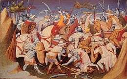
The Ifat Sultanate was a medieval kingdom in the Horn of Africa. Founded in 1285 by the Walashma dynasty, it was centered in Zeila.[16][17] Ifat established bases in Djibouti and northern Somalia, and from there expanded southward to the Ahmar Mountains. Its Sultan Umar Walashma (or his son Ali, according to another source) is recorded as having conquered the Sultanate of Shewa in 1285. Taddesse Tamrat explains Sultan Umar's military expedition as an effort to consolidate the Muslim territories in the Horn, in much the same way as Emperor Yekuno Amlak was attempting to unite the Christian territories in the highlands during the same period. These two states inevitably came into conflict over Shewa and territories further south. A lengthy war ensued, but the Muslim sultanates of the time were not strongly unified. Ifat was finally defeated by Emperor Amda Seyon I of Ethiopia in 1332, and withdrew from Shewa.
Egypt Eyalet
Governor Abou Baker ordered the Egyptian garrison at Sagallo to retire to Zeila. The cruiser Seignelay reached Sagallo shortly after the Egyptians had departed. French troops occupied the fort despite protests from the British Agent in Aden, Major Frederick Mercer Hunter, who dispatched troops to safeguard British and Egyptian interests in Zeila and prevent further extension of French influence in that direction.[18] On the 14 April 1884 the Commander of the patrol sloop L’Inferent reported on the Egyptian occupation in the Gulf of Tadjoura. The Commander of the patrol sloop Le Vaudreuil reported that the Egyptians were occupying the interior between Obock and Tadjoura. Emperor Johannes IV of Ethiopia signed an accord with the United Kingdom to cease fighting the Egyptians and to allow the evacuation of Egyptian forces from Ethiopia and the Somali Coast ports. The Egyptian garrison was withdrawn from Tadjoura. Léonce Lagarde deployed a patrol sloop to Tadjoura the following night.
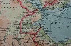
French Somaliland
The boundaries of the present-day Djibouti nation state were established during the Scramble for Africa. It was Rochet d'Hericourt's exploration into Shoa (1839–42) that marked the beginning of French interest in the Djiboutian coast of the Red Sea. Rochet d'Héricourt acquired the town of Tadjoura from the King Of Shewa in 1842. The problem was that this king was not the owner of Tadjoura, but a local sultan who did not recognize the purchase contract, further exploration by Henri Lambert, French Consular Agent at Aden, and Captain Fleuriot de Langle led to a treaty of friendship and assistance between France and the sultans of Raheita, Tadjoura, and Gobaad, from whom the French purchased the anchorage of Obock in 1862.
Growing French interest in the area took place against a backdrop of British activity in Egypt and the opening of the Suez Canal in 1869. Between 1883–87, France signed various treaties with the then ruling Somali and Afar Sultans, which allowed it to expand the protectorate to include the Gulf of Tadjoura.[19][20] Léonce Lagarde was subsequently installed as the protectorate's governor. In 1894, he established a permanent French administration in the city of Djibouti and named the region Côte française des Somalis (French Somaliland), a name which continued until 1967. The territory's border with Ethiopia, marked out in 1897 by France and Emperor Menelik II of Ethiopia, was later reaffirmed by agreements with Emperor Haile Selassie I of Ethiopia in 1945 and 1954.
In 1889, a Russian by the name of Nikolay Ivanovitch Achinov[21][22] (b. 1856[23]), arrived with settlers, infantry and an Orthodox priest to Sagallo on the Gulf of Tadjoura. The French considered the presence of the Russians as a violation of their territorial rights and dispatched two gunboats. The Russians were bombarded and after some loss of life, surrendered. The colonists were deported to Odessa and the dream of Russian expansion in East Africa came to an end in less than one year.
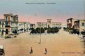
The administrative capital was moved from Obock in 1896. The city of Djibouti, which had a harbor with good access that attracted trade caravans crossing East Africa, became the new administrative capital. The Franco-Ethiopian railway, linking Djibouti to the heart of Ethiopia, began in 1897 and reached Addis Ababa in June 1917, increasing the volume of trade passing through the port.
World War II
After the Italian invasion and occupation of Ethiopia in the mid-1930s, constant border skirmishes occurred between French forces in French Somaliland and Italian forces in Italian East Africa. In June 1940, during the early stages of World War II, France fell and the colony was then ruled by the pro-Axis Vichy (French) government.
British and Commonwealth forces fought the neighboring Italians during the East African Campaign. In 1941, the Italians were defeated and the Vichy forces in French Somaliland were isolated. The Vichy French administration continued to hold out in the colony for over a year after the Italian collapse. In response, the British blockaded the port of Djibouti City but it could not prevent local French from providing information on the passing ship convoys. In 1942, about 4,000 British troops occupied the city. A local battalion from French Somaliland participated in the Liberation of Paris in 1944.
Referendums
In 1958, on the eve of neighboring Somalia's independence in 1960, a referendum was held in Djibouti to decide whether or not to join the Somali Republic or to remain with France. The referendum turned out in favour of a continued association with France, partly due to a combined yes vote by the sizable Afar ethnic group and resident Europeans.[24] There were also reports of widespread vote rigging, with the French expelling thousands of Somalis before the referendum reached the polls.[25] The majority of those who voted no were Somalis who were strongly in favour of joining a united Somalia as had been proposed by Mahmoud Harbi, Vice President of the Government Council. Harbi died in a plane crash two years later under mysterious circumstances.[24][26]
In 1960, with the fall of the ruling Dini administration, Ali Aref Bourhan, a Harbist politician, assumed the seat of Vice President of the Government Council of French Somaliland, representing the UNI party.[27][28] He would hold that position until 1966.
That same year, France rejected the United Nations' recommendation that it should grant French Somaliland independence. In August, an official visit to the territory by then French President, General Charles de Gaulle, was also met with demonstrations and rioting.[29][30] In response to the protests, de Gaulle ordered another referendum.[30]
On 19 March 1967, a second plebiscite was held to determine the fate of the territory. Initial results supported a continued but looser relationship with France. Voting was also divided along ethnic lines, with the resident Somalis generally voting for independence, with the goal of eventual reunion with Somalia, and the Afars largely opting to remain associated with France.[29] However, the referendum was again marred by reports of vote rigging on the part of the French authorities,[31] with some 10,000 Somalis deported under the pretext that they did not have valid identity cards.[32] According to official figures, although the territory was at the time inhabited by 58,240 Somali and 48,270 Afar, only 14,689 Somali were allowed to register to vote versus 22,004 Afar.[33] Somali representatives also charged that the French had simultaneously imported thousands of Afar nomads from neighboring Ethiopia to further tip the odds in their favor, but the French authorities denied this, suggesting that Afars already greatly outnumbered Somalis on the voting lists.[32] Announcement of the plebiscite results sparked civil unrest, including several deaths. France also increased its military force along the frontier.[32][34]
French Territory of the Afars and Issas
In 1967, shortly after the second referendum was held, the former Côte française des Somalis (French Somaliland) was renamed to Territoire français des Afars et des Issas. This was both in acknowledgement of the large Afar constituency and to downplay the significance of the Somali composition (the Issa being a Somali sub-clan).[34]
The French Territory of Afars and Issas also differed from French Somaliland in terms of government structure, as the position of governor changed to that of high commissioner. A nine-member council of government was also implemented.
With a steadily enlarging Somali population, the likelihood of a third referendum appearing successful had grown even more dim. The prohibitive cost of maintaining the colony and the fact that after 1975, France found itself to be the last remaining colonial power in Africa was another factor that compelled observers to doubt that the French would attempt to hold on to the territory.[30]
In 1976, the French garrison, centered on the 13th Demi-Brigade of the Foreign Legion (13 DBLE), had to be reinforced to contain Somali irredentist aspirations, revolting against the French-engineered Afar domination of the emerging government.[35] The French forces were involved in the response to the on 3 February 1976.
On June 27, 1977, a third vote took place. A landslide 98.8% of the electorate supported disengagement from France, officially marking Djibouti's independence.[30][36] Hassan Gouled Aptidon, a Somali politician who had campaigned for a yes vote in the referendum of 1958, eventually became the nation's first president (1977–1999).[24]
After independence the new government signed an agreement calling for a strong French garrison, though the 13 DBLE was envisaged to be withdrawn.[37] While the unit was reduced in size, a full withdrawal never actually took place.
Djibouti Republic
In 1981, Aptidon turned the country into a one party state by declaring that his party, the Rassemblement Populaire pour le Progrès (RPP) (People's Rally for Progress), was the sole legal one. Clayton writes that the French garrison played the major role in suppressing further minor unrest about this time, during which Djibouti became a one-party state on a much broader ethnic and political basis.[38]
A civil war broke out in 1991, between the government and a predominantly Afar rebel group, the Front for the Restoration of Unity and Democracy (FRUD). The FRUD signed a peace accord with the government in December 1994, ending the conflict. Two FRUD members were made cabinet members, and in the presidential elections of 1999 the FRUD campaigned in support of the RPP.
Aptidon resigned as president 1999, at the age of 83, after being elected to a fifth term in 1997. His successor was his nephew, Ismail Omar Guelleh.
On May 12, 2001, President Ismail Omar Guelleh presided over the signing of what is termed the final peace accord officially ending the decade-long civil war between the government and the armed faction of the FRUD, led by Ahmed Dini Ahmed, an Afar nationalist and former Gouled political ally. The peace accord successfully completed the peace process begun on February 7, 2000 in Paris. Ahmed Dini Ahmed represented the FRUD.[39]
In the presidential election held April 8, 2005, Ismail Omar Guelleh was re-elected to a second 6-year term at the head of a multi-party coalition that included the FRUD and other major parties. A loose coalition of opposition parties again boycotted the election. Currently, political power is shared by a Somali president and an Afar prime minister, with an Afar career diplomat as Foreign Minister and other cabinet posts roughly divided. However, Issas are predominate in the government, civil service, and the ruling party. That, together with a shortage of non-government employment, has bred resentment and continued political competition between the Issa Somalis and the Afars. In March 2006, Djibouti held its first regional elections and began implementing a decentralization plan. The broad pro-government coalition, including FRUD candidates, again ran unopposed when the government refused to meet opposition preconditions for participation. In the 2008 elections, the opposition Union for a Presidential Majority (UMP) party boycotted the election, leaving all 65 seats to the ruling RPP. Voter turnout figures were disputed. Guelleh was re-elected in the 2011 presidential election.
Due to its strategic location at the mouth of the Bab el Mandeb gateway to the Red Sea and the Suez Canal, Djibouti also hosts various foreign military bases. Camp Lemonnier is a United States Naval Expeditionary Base,[40] situated at Djibouti-Ambouli International Airport and home to the Combined Joint Task Force - Horn of Africa (CJTF-HOA) of the U.S. Africa Command (USAFRICOM).[41] In 2011, Japan also opened a local naval base staffed by 180 personnel to assist in marine defense. This initiative is expected to generate $30 million in revenue for the Djiboutian government.[42]
See also
- Colonial heads of Djibouti (French Somaliland)
- French Territory of the Afars and the Issas (FTAI)
- French Somaliland
- Heads of government of Djibouti
- History of Africa
- List of Presidents of Djibouti
- Politics of Djibouti
- Djibouti City history and timeline
References
- Notes
- Walter Raunig, Steffen Wenig (2005). Afrikas Horn. Otto Harrassowitz Verlag. p. 439. ISBN 3447051752. Retrieved 7 September 2014.
- Connah, Graham (2004). Forgotten Africa: An Introduction to Its Archaeology. Routledge. p. 46. ISBN 1134403038. Retrieved 7 September 2014.
- Universität Frankfurt am Main (2003). Journal of African Archaeology, Volumes 1–2. Africa Manga Verlag. p. 230. Retrieved 7 September 2014.
- Simson Najovits, Egypt, trunk of the tree, Volume 2, (Algora Publishing: 2004), p.258.
- Tyldesley, Hatchepsut, p.147
- Breasted 1906–07, pp. 246–295, vol. 1.
- The Geography of Herodotus: Illustrated from Modern Researches and Discoveries by James Talboys Wheeler pg 528. The British Critic, Quarterly Theological Review, And Ecclesiastical Record Volume 11 pg 434
- Wheeler pg 526
- John Kitto, James Taylor, The popular cyclopædia of Biblical literature: condensed from the larger work, (Gould and Lincoln: 1856), p.302.
- Briggs, Phillip (2012). Somaliland. Bradt Travel Guides. p. 7. ISBN 1841623717.
- Encyclopedia Americana, Volume 25. Americana Corporation. 1965. p. 255.
- Lewis, I.M. (1955). Peoples of the Horn of Africa: Somali, Afar and Saho. International African Institute. p. 140.
- Fattovich, Rodolfo (1987). "Some remarks on the origins of the Aksumite Stelae" (PDF). Annales d'Éthiopie. 14 (14): 43–69. Archived from the original (PDF) on 2015-09-24. Retrieved 7 September 2014.
- "Tiya – Prehistoric site". UNESCO. Retrieved 24 December 2014.
- Fukui, Katsuyoshi (1997). Ethiopia in broader perspective: papers of the XIIIth International Conference of Ethiopian Studies Kyoto 12–17 December 1997. Shokado Book Sellers. p. 370. ISBN 4879749761. Retrieved 23 December 2014.
- J. Gordon Melton and Martin Baumann, Religions of the World, Second Edition: A Comprehensive Encyclopedia of Beliefs and Practices, page 2663
- Asafa Jalata, State Crises, Globalisation, And National Movements In North-east Africa page 3-4
- "Archived copy". Archived from the original on 2013-06-09. Retrieved 2013-04-19.CS1 maint: archived copy as title (link) FRENCH SOMALI COAST Timeline
- Raph Uwechue, Africa year book and who's who, (Africa Journal Ltd.: 1977), p. 209.
- Hugh Chisholm (ed.), The encyclopædia britannica: a dictionary of arts, sciences, literature and general information, Volume 25, (At the University press: 1911), p. 383.
- Ashinov, Achinov, Atchinoff or Atchimoff
- (in French) Le cosaque Achinoff in Le Progrès Illustré (French daily newspaper), March 1, 1891
- Ernest A. Wallis Budge, A history of Ethiopia, Nubia and Abyssinia, Taylor & Francis, 1928.
- Barrington, Lowell, After Independence: Making and Protecting the Nation in Postcolonial and Postcommunist States, (University of Michigan Press: 2006), p. 115 ISBN 0472068989
- Kevin Shillington, Encyclopedia of African history, (CRC Press: 2005), p. 360 ISBN 1579582451.
- United States Joint Publications Research Service, Translations on Sub-Saharan Africa, Issues 464–492, (1966), p.24.
- Worldstatesmen – DJibouti
- Jacques Foccart et Ali Aref
- A Political Chronology of Africa, (Taylor & Francis), p.132.
- Newsweek, Volume 81, (Newsweek: 1973), p.254.
- American Universities Field Staff, Northeast Africa series, Volume 15, Issue 1, (American Universities Field Staff.: 1968), p.3.
- Jean Strouse, Newsweek, Volume 69, Issues 10–17, (Newsweek: 1967), p.48.
- Africa Research, Ltd, Africa contemporary record: annual survey and documents, Volume 1, (Africana Pub. Co.: 1969), p.264.
- Alvin J. Cottrell, Robert Michael Burrell, Georgetown University. Center for Strategic and International Studies, The Indian Ocean: its political, economic, and military importance, (Praeger: 1972), p.166.
- Clayton 1988, 236.
- Elections in Djibouti African Elections Database
- Clayton 1988, 236.
- Clayton 1988, 236.
- "Djibouti (09/06)". U.S. Department of State. Retrieved 2017-06-09.
- "Introduction to MARCENT". United States Marine Corps. May 2006. Archived from the original (PPT) on October 25, 2007. Retrieved February 9, 2007.
- "Africans Fear Hidden U.S. Agenda in New Approach to Africom". Associated Press. September 30, 2008. Archived from the original on 2013-04-02. Retrieved September 30, 2008.
- "Japan Opens Military Base in Djibouti to Help Combat Piracy". Bloomberg. July 8, 2011.
- Bibliography
- Clayton, Anthony (1988). France, Soldiers, and Africa. Brassey's Defence Publishers.
External links
| History |
| | |
|---|---|---|---|
| Geography | |||
| Politics |
| ||
| Economy | |||
| Culture |
| ||
| Former |
| ||||||||||||||||||||||||||||||||||||||||
|---|---|---|---|---|---|---|---|---|---|---|---|---|---|---|---|---|---|---|---|---|---|---|---|---|---|---|---|---|---|---|---|---|---|---|---|---|---|---|---|---|---|
| Present |
| ||||||||||||||||||||||||||||||||||||||||