Obock
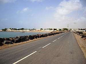
Obock (also Obok, Afar: Hayyú) is a small port town in Djibouti. It is located on the northern shore of the Gulf of Tadjoura, where it opens out into the Gulf of Aden. The town is home to an airstrip and has ferries to Djibouti City, while mangroves lie nearby. The French form Obock derives from Arabic "Oboh", deformation of Oboki, a name given to the Wadi Dar'i in its middle part, upstream of its coastal delta.
Obock Hayyú | |
|---|---|
Town | |
 | |
 Obock Location in Djibouti | |
| Coordinates: 11°58′N 43°17′E | |
| Country | |
| Region | Obock Region |
| Area | |
| • Total | 2 km2 (0.8 sq mi) |
| Elevation | 13 m (43 ft) |
| Population (2009) | |
| • Total | 11,706 |
Overview
Obock is located in east of the northern coast of the Gulf of Tadjoura, the door of the Bab el Mandeb Strait and in the north-east of the Republic of Djibouti, 237 km (147 mi) (by road) of Djibouti City.
History
| Historical affiliations |
|---|
| Ifat Sultanate 1285–1415 |
| Adal Sultanate 1415–1577 |
| Egypt Eyalet 1554–1882 |
During antiquity Obock was part of the city-states that in engaged in a lucrative trade network connecting the merchants with Phoenicia, Ptolemaic Egypt, Greece, Parthian Persia, Saba, Nabataea, and the Roman Empire.
During the Middle Ages, Obock (Hayyú) was ruled by the Ifat Sultanate and the Adal Sultanate. The Ottoman Empire had control over the area from the sixteenth to the nineteenth century. It later was part of the French Somaliland protectorate in the first half of the 20th century. Obock was originally significant as the site of the first French colony in the region, established by treaty with the local Afar rulers on March 11, 1862.[1] The French were interested in having a coaling station for steamships, which would become especially important upon the opening of the Suez Canal in 1869. (Up to that time French ships had to buy coal at the British port of Aden across the gulf, an unwise dependency in case of war.)
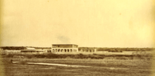
The site was not the subject of any occupation, just visited by the ships of the naval divisions assigned to the Indian Ocean, until the installation of trader Pierre Arnoux in 1881, followed by Paul Soleillet. Obock became a true colony in 1884 with the arrival in August of Léonce Lagarde, who established an administration and extended French possession in the Gulf of Tadjoura, forming the Territory of Obock and outbuildings, with Obock as its capital. By 1885, Obock had 800 inhabitants and a school. However, the anchorage was more exposed than the site of Djibouti on the south side of the Gulf of Tadjoura, and the colonial administration moved there in 1894. The population of Obock subsequently declined.[2]
.jpg)
However, until the occupation of Tadjoura in 1927, Obock remained the only place on the northern coast of the Gulf of Tadjoura with a colonial administration. It became the capital of the "District Dankali" in 1914, then an administrative position from 1927 which was subsumed into the "Circle of Adaels" in 1929. In 1931 Obock became the capital of a circle responsible for resupplying the colony during the Allied blockade from 1941 to 1943, then again a simple administrative position, and then became a capital of the circle from 1963 to Djiboutian independence in 1977.
Obock is expected to be the site of the Chinese naval base in Djibouti.[3][4]
Postage stamps
During its time as a French colony, Obock issued its own postage stamps; for more detail see Postage stamps and postal history of Obock.
Climate and geography
Obock has a dry climate. It is classified as hot and semi-arid (Köppen climate classification BSh). Obock is 13 m above sea level on the plateau of Gazelles ("Dala-h Húgub in Afar") in desert terrain. The sky is always clear and bright throughout the year.[5]
| Climate data for Obock | |||||||||||||
|---|---|---|---|---|---|---|---|---|---|---|---|---|---|
| Month | Jan | Feb | Mar | Apr | May | Jun | Jul | Aug | Sep | Oct | Nov | Dec | Year |
| Average high °C (°F) | 28.9 (84.0) |
29.0 (84.2) |
30.8 (87.4) |
32.8 (91.0) |
35.4 (95.7) |
38.6 (101.5) |
41.0 (105.8) |
39.9 (103.8) |
37.0 (98.6) |
33.8 (92.8) |
31.0 (87.8) |
29.5 (85.1) |
34.0 (93.1) |
| Average low °C (°F) | 22.3 (72.1) |
23.3 (73.9) |
24.6 (76.3) |
26.0 (78.8) |
28.2 (82.8) |
30.7 (87.3) |
30.8 (87.4) |
30.1 (86.2) |
30.0 (86.0) |
26.4 (79.5) |
24.2 (75.6) |
22.7 (72.9) |
26.6 (79.9) |
| Average precipitation mm (inches) | 4 (0.2) |
6 (0.2) |
16 (0.6) |
4 (0.2) |
7 (0.3) |
0 (0) |
5 (0.2) |
6 (0.2) |
3 (0.1) |
5 (0.2) |
14 (0.6) |
10 (0.4) |
80 (3.2) |
| Source 1: Climate-Data.org, altitude: 13m[5] | |||||||||||||
| Source 2: Levoyageur[6] | |||||||||||||
The submarine coastal spring waters have an interesting geothermal potential (with a deep temperature of approximatively 200°C).[7]
Notable residents
- Hasna Mohamed Dato, Politician
- Abdallah Mohamed Kamil, Politician
- Henry de Monfreid, Adventurer, writer
References
- Scott's monthly stamp journal. 1 January 1982. p. 5. Retrieved 29 May 2011.
- "Chisholm, Hugh, ed. (1911). . Encyclopædia Britannica. 19 (11th ed.). Cambridge University Press. p. 593.
- Panda, Ankit (February 29, 2016). "Confirmed: Construction Begins on China's First Overseas Military Base in Djibouti". The Diplomat. Archived from the original on May 14, 2017. Retrieved May 17, 2017. Italic or bold markup not allowed in:
|publisher=(help) - "Defense Ministry's regular press conference on Feb.25". Ministry of National Defense of the People's Republic of China. February 15, 2016. Archived from the original on May 17, 2017.
- "Climate: Dikhil - Climate graph, Temperature graph, Climate table". Climate-Data.org. Retrieved 30 September 2013.
- "DJIBOUTI - OBOCK : Climate, weather, temperatures". Levoyageur. Retrieved 5 September 2016.
- Awaleh, Mohamed Osman; Hoch, Farhan Bouraleh; Kadieh, Ibrahim Houssein; Soubaneh, Youssouf Djbril; Egueh, Nima Moussa; Jalludin, Mohamed; Boschetti, Tiziano (2015). "The geothermal resources of the Republic of Djibouti — I: Hydrogeochemistry of the Obock coastal hot springs". Journal of Geochemical Exploration. 152: 54–66. doi:10.1016/j.gexplo.2015.02.001.