Zeila
Zeila (Somali: Saylac, Arabic: زيلع, romanized: Zaylaʿ), also known as Zaila or Zeyla, is a port city in the western Awdal region of Somaliland.[2]
Zeila Saylac زيلع | |
|---|---|
Town | |
 Zeila waterfront circa 1880 | |
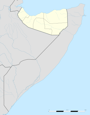 Zeila Location in Somaliland | |
| Coordinates: 11°21′14″N 43°28′26″E | |
| Country | |
| Region | Awdal |
| District | Zeylac |
| Established | ca. 1st century CE |
| Population (2012) | |
| • Total | 18,600[1] |
| Time zone | UTC+3 (EAT) |
| Climate | BWh |
In the Middle Ages, the Jewish traveller Benjamin of Tudela identified Zeila (or Zawilah) with the Biblical location of Havilah.[3] Most modern scholars identify it with the site of Avalites mentioned in the 1st-century Greco-Roman travelogue the Periplus of the Erythraean Sea and in Ptolemy, although this is disputed.[4][5] The town evolved into an early Islamic center with the arrival of Muslims shortly after the hegira. By the 9th century, Zeila was the capital of the early Adal Kingdom and Ifat Sultanate in the 13th century, and also a capital for its successor state the Adal Sultanate, it would attain its height of prosperity a few centuries later in the 16th century. The city subsequently came under Ottoman and British protection in the 18th century.
Geography
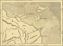
Zeila is situated in the Awdal region in Somaliland. Located on the Gulf of Aden coast near the Djibouti border, the town sits on a sandy spit surrounded by the sea. It is known for its coral reef, mangroves and offshore islands, which include the Sa'ad ad-Din archipelago named after the Somali Sultan Sa'ad ad-Din II of the Sultanate of Ifat.[6] Landward, the terrain is unbroken desert for some fifty miles. Berbera lies 170 miles (270 km) southeast of Zeila, while the city of Harar in Ethiopia is 200 miles (320 km) to the west.
History
Avalites
During antiquity Zeila was part of the Somali city-states that in engaged in a lucrative trade network connecting Somali merchants with Phoenicia, Ptolemaic Egypt, Greece, Parthian Persia, Saba, Nabataea, and the Roman Empire. Somali sailors used the ancient Somali maritime vessel known as the beden to transport their cargo.[7]
_(14582488388).jpg)
Zeila is an ancient city, and has been identified with what was referred to in classical antiquity as the town of Avalites (Greek: Αβαλίτες), situated in the erstwhile Barbara geographical region on the northern Somali coast. Along with the neighboring Habash (Habesha or Abyssinians) of Al-Habash to the west, the Barbaroi or Berber (ancestral Somalis) who inhabited the area are recorded in the 1st century CE Greek document the Periplus of the Erythraean Sea as engaging in extensive commercial exchanges with Egypt and pre-Islamic Arabia. The travelogue mentions the Barbaroi trading frankincense, among various other commodities, through their port cities such as Avalites (modern Zeila). Competent seamen, the Periplus' author also indicates that they sailed throughout the Red Sea and Gulf of Aden for trade. The document describes the Barbaroi's system of governance as decentralized, and essentially consisting of a collection of autonomous city-states.[8] It also suggests that "the Berbers who live in the place are very unruly",[9] an apparent reference to their independent streak.[8]
Adal kingdom
Islam was introduced to the area early on from the Arabian Peninsula, shortly after the hegira. Zeila's two-mihrab Masjid al-Qiblatayn dates to the 7th century, and is the oldest mosque in the city.[10] In the late 9th century, Al-Yaqubi wrote that Muslims were living along the northern Somali seaboard.[11] He also mentioned that the Adal kingdom had its capital in the city,[11][12] suggesting that the Adal Sultanate with Zeila as its headquarters dates back to at least the 9th or 10th centuries. According to I.M. Lewis, the polity was governed by local dynasties consisting of Somalized Arabs or Arabized Somalis, who also ruled over the similarly-established Sultanate of Mogadishu in the Benadir region to the south. Adal's history from this founding period forth would be characterized by a succession of battles with neighbouring Abyssinia.[12]
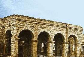
By the year of (1214-17), Ibn Said referred to both Zeila and Berbera. Zeila, as he tells us, was a wealthy city of considerable size and its inhabitants were completely Muslims. Ibn Said's description gives the impression that Berbera was of much more localized importance, mainly serving the immediate Somali, hinterland while Zeila was clearly serving more extensive areas. But there is no doubt that Zeila was also predominantly Somali, and Al-Dimashqi, another thirteen-century Arab writer, gives the city name its Somali name Awdal (Adal), still known among the local Somali. By the fourteen century, the significance of this Somali port for the Ethiopian interior increased so much so that all the Muslim communities established along the trade routes into central and south-eastern Ethiopia were commonly known in Egypt and Syria by the collective term of "the country of Zeila".[13]
In the following century, the Moroccan historian and traveller Ibn Battuta describes the city being inhabited by Somalis, followers of the Shafi‘i school, who kept large numbers of camels, sheep and goats. His description thus indicates both the ingenious nature of the city, as indicated by the composition of its population, and, by implication through the presence of the livestock, the existence of the nomads in its vicinity. He also describes Zeila as a big metropolis city and many great markets filled with many wealthy merchants.[14]
Through extensive trade with Abyssinia and Arabia, Adal attained its height of prosperity during the 14th century.[15] It sold incense, myrrh, slaves, gold, silver and camels, among many other commodities. Zeila had by then started to grow into a huge multicultural metropolis, with Somalis (Predominantly), Afar, Harari, and even Arabs and Persian inhabitants. The city was also instrumental in bringing Islam to the Oromo and other Ethiopian ethnic groups.[16]
In 1332, the Zeila-based King of Adal was slain in a military campaign aimed at halting the Abyssinian Emperor Amda Seyon's march toward the city.[17] When the last Sultan of Ifat, Sa'ad ad-Din II, was also killed by Dawit I of Ethiopia in Zeila in 1410, his children escaped to Yemen, before later returning in 1415.[18] In the early 15th century, Adal's capital was moved further inland to the town of Dakkar, where Sabr ad-Din II, the eldest son of Sa'ad ad-Din II, established a new base after his return from Yemen.[19][20] Adal's headquarters were again relocated the following century, this time to Harar. From this new capital, Adal organised an effective army led by Imam Ahmad ibn Ibrahim al-Ghazi (Ahmad "Gurey" or "Gran") that invaded the Abyssinian empire.[20] This campaign is historically known as the Conquest of Abyssinia (Futuh al Habash). During the war, Imam Ahmad pioneered the use of cannons supplied by the Ottoman Empire, which he imported through Zeila and deployed against Abyssinian forces and their Portuguese allies led by Cristóvão da Gama.[15] Some scholars argue that this conflict proved, through their use on both sides, the value of firearms like the matchlock musket, cannons and the arquebus over traditional weapons.[21]
Travellers' reports, such as the memoirs of the Italian Ludovico di Varthema, indicate that Zeila continued to be an important marketplace during the 16th century,[22] despite being sacked by the Portuguese in 1517 and 1528. Later that century, separate raids by nomads from the interior eventually prompted the port's then ruler, Garad Lado, to enlist the services of 'Atlya ibn Muhammad to construct a sturdy wall around the city.[23] Zeila, however, ultimately began to decline in importance following the short-lived conquest of Abyssinia.[15]
16th century Zeila, along with several other settlements on the East African coast, had been visited by the Portuguese explorer and writer Duarte Barbosa, describing the city as such: "Having passed this town of Berbara, and going on, entering the Red Sea, there is another town of the Moors, which is named Zeyla, which is a good place of trade, whither many ships navigate and sell their cloths and merchandise. It is very populous, with good houses of stone and white-wash, and good streets ; the houses are covered with terraces, the dwellers in them are black. They have many horses, and breed much cattle of all sorts, which they make use of for milk, and butter, and meat. There is in this country abundance of wheat, millet, barley, and fruits, which they carry thence to Aden." [24]
Yemenite period
Beginning in 1630, the city became a dependency of the ruler of Mocha, who, for a small sum, leased the port to one of the office-holders of Mocha. The latter in return collected a toll on its trade. Zeila was subsequently ruled by an Emir, whom Mordechai Abir suggested had "some vague claim to authority over all of the sahil, but whose real authority did not extend very far beyond the walls of the town." Assisted by cannons and a few mercenaries armed with matchlocks, the governor succeeded in fending off incursions by both the disunited nomads of the interior, who had penetrated the area, as well as brigands in the Gulf of Aden.[25] By the first half of the 19th century, Zeila was a shadow of its former self, having been reduced to "a large village surrounded by a low mud wall, with a population that varied according to the season from 1,000 to 3,000 people."[26] The city continued to serve as the principal maritime outlet for Harar and beyond it in Shewa. However, the opening of a new sea route between Tadjoura and Shewa cut further into Zeila's historic position as the main regional port.[27]
Ottoman period
Although part of the Ottoman Empire since 1559, between 1821 and 1841, Muhammad Ali, Pasha of Egypt, came to control Yemen and the sahil, with Zeila included.[28] After the Egyptians withdrew from the Yemeni seaboard in 1841, Haj Ali Shermerki, a successful and ambitious Somali merchant, purchased from them executive rights over Zeila. Shermerki's governorship had an instant effect on the city, as he maneuvered to monopolize as much of the regional trade as possible, with his sights set as far as Harar and the Ogaden. In 1845, Shermerki deployed a few matchlock men to wrest control of neighboring Berbera from that town's then feuding Somali authorities. This alarmed the Emir of Harar, who, having already been at loggerheads with Shermerki over fiscal matters, was concerned about the ramifications that these movements might ultimately have on his own city's commerce. The Emir consequently urged Berbera's leaders to reconcile and mount a resistance against Shermerki's troops.[29] Shermerki was later succeeded as Governor of Zeila by Abu Bakr Pasha, a local Afar statesman.[30]

In 1874–75, the Egyptians obtained a firman from the Ottomans by which they secured claims over the city. At the same time, the Egyptians received British recognition of their nominal jurisdiction as far east as Cape Guardafui.[28] In actuality, however, Egypt had little authority over the interior and their period of rule on the coast was brief, lasting only a few years (1870–84). When the Egyptian garrison in Harar was evacuated in 1885, Zeila became caught up in the competition between the Tadjoura-based French and the British for control of the strategic Gulf of Aden littoral. I. M. Lewis mentions that "by the end of 1885 Britain was preparing to resist an expected French landing at Zeila."[30] However, the two powers decided instead to turn to negotiations.
British Somaliland
On 9 February 1888, France and Britain concluded an agreement defining the boundary between their respective protectorates.[31] As a result, Zeila and its eastern neighbor Berbera came to be part of British Somaliland.
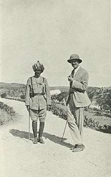
The construction of a railway from Djibouti to Addis Ababa in the late 19th century continued the neglect of Zeila.[32] At the beginning of the next century, the city was described in the 1911 Encyclopædia Britannica as having a "good sheltered anchorage much frequented by Arab sailing craft. However, heavy draught steamers are obliged to anchor a mile and a half from the shore. Small coasting boats lie off the pier and there is no difficulty in loading or discharging cargo. The water supply of the town is drawn from the wells of Takosha, about three miles distant; every morning camels, in charge of old Somali women and bearing goatskins filled with water, come into the town in picturesque procession. ... [Zeila's] imports, which reach Zaila chiefly via Aden, are mainly cotton goods, rice, jowaree, dates and silk; the exports, 90% of which are from Abyssinia, are principally coffee, skins, ivory, cattle, ghee and mother-of-pearl".[32]
In August 1940, Zeila was captured by advancing Italian troops. It would remain under their occupation for over six months.
Present
In the post-independence period, Zeila was administered as part of the official Awdal region of Somaliland.
Following the outbreak of the civil war in the early 1990s, much of the city's historic infrastructure was destroyed and many residents left the area. However, remittance funds sent by relatives abroad have contributed toward reconstruction of the town, as well as the local trade and fishing industries.
Demographics
As of 2012, Zeila had a population of around 18,600 inhabitants.[1] The broader Zeila District has a total population of 105,000 residents.[33]
The city of Zeila is inhabited by people from the Somali ethnic group.
Education
Zeila has 5 schools that provide primary education to 484 students.[34]
References
- Somalia City & Town Population. Tageo.com. Retrieved 2020-03-18.
- "Somalia City & Town Population" (PDF). FAO. Archived from the original (PDF) on 11 February 2015. Retrieved 20 October 2015.
- François-Xavier Fauvelle-Aymar, "Desperately Seeking the Jewish Kingdom of Ethiopia: Benjamin of Tudela and the Horn of Africa (Twelfth Century)", Speculum, 88.2 (2013): 383–404.
- G. W. B. Huntingford (ed.), The Periplus of the Erythraean Sea, by an Unknown Author: With Some Extracts from Agatharkhides ‘On the Erythraean Sea’ (Ashgate, 1980), p. 90.
- Lionel Casson (ed.), The Periplus Maris Erythraei: Text with Introduction, Translation and Commentary (Princeton University Press, 1989), pp. 116–17. Avalites may be Assab or a village named Abalit near Obock.
- T. R. McClanahan 2000, p. 273.
- Journal of African History pg.50 by John Donnelly Fage and Roland Anthony Oliver
- Mohamed Diriye Abdullahi, Culture and Customs of Somalia, (Greenwood Press, 2001), pp.13–14
- Wilfred Harvey Schoff, The Periplus of the Erythraean Sea: travel and trade in the Indian Ocean, (Longmans, Green, and Co., 1912) p.25
- Briggs, Phillip (2012). Somaliland. Bradt Travel Guides. p. 7. ISBN 1841623717.
- Encyclopedia Americana, Volume 25. Americana Corporation. 1965. p. 255.
- Lewis, I.M. (1955). Peoples of the Horn of Africa: Somali, Afar and Saho. International African Institute. p. 140.
- The Cambridge History of Africa. 3.
- The Archaeology of Islam in Sub-Saharan Africa.
- I. M. Lewis, A pastoral democracy: a study of pastoralism and politics among the Northern Somali of the Horn of Africa, (LIT Verlag Münster: 1999), p.17
- Rayne, Henry A. Sun, sand and somals : leaves from the note-book of a district commissioner in British Somaliland. London : Witherby. (1921). https://archive.org/stream/sunsandsomalslea00raynuoft/sunsandsomalslea00raynuoft_djvu.txt
- Houtsma, M. Th (1987). E.J. Brill's First Encyclopaedia of Islam, 1913–1936. BRILL. pp. 125–126. ISBN 9004082654.
- mbali, mbali (2010). "Somaliland". Basic Reference. London, UK: mbali. 28: 217–229. doi:10.1017/S0020743800063145. Archived from the original on 2012-04-23. Retrieved 2012-04-27.
- Briggs, Philip (2012). Bradt Somaliland: With Addis Ababa & Eastern Ethiopia. Bradt Travel Guides. p. 10. ISBN 1841623717.
- Lewis, I. M. (1999). A Pastoral Democracy: A Study of Pastoralism and Politics Among the Northern Somali of the Horn of Africa. James Currey Publishers. p. 17. ISBN 0852552807.
- Jeremy Black, Cambridge Illustrated Atlas, Warfare: Renaissance to Revolution, 1492–1792, (Cambridge University Press: 1996), p.9.
- "There is an abundance of provisions in this city, and there are many merchants here." The Travels of Ludovico di Varthema in Egypt, Syria, Arabia Deserta and Arabia Felix, in Persia, India, and Ethiopia, A.D. 1503 to 1508, translated by John Winter Jone, and edited by George Percy Badger (London: the Hakluyt Society, 1863), p. 87
- Pankhurst, Richard (1982). History of Ethiopian towns from the Middle Ages to the early nineteenth century. Steiner. p. 63. ISBN 3515032045.
- Dames, L., 1918: The Book of Duarte Barbosa London: Hakluyt Society
- Abir, Mordechai (1968). Ethiopia: The Era of the Princes; The Challenge of Islam and the Re-unification of the Christian Empire (1769–1855). London: Longmans. p. 15. Abir defines the sahil as "the coast", which stretched from the Gulf of Tadjoura to Cape Guardafui
- Abir, Era of the Princes, p. 14
- Abir, Era of the Princes, p. 16
- E. H. M. Clifford, "The British Somaliland-Ethiopia Boundary", Geographical Journal, 87 (1936), p. 289
- Abir, Mordechai (1968). Ethiopia: the era of the princes: the challenge of Islam and re-unification of the Christian Empire, 1769–1855. Praeger. p. 18.
- I.M. Lewis, A Modern History of the Somali, fourth edition (Oxford: James Currey, 2002), p.43 & 49
- Simon Imbert-Vier, Frontières et limites à Djibouti durant la période coloniale (1884–1977), Université de Provence, Aix-Marseille, 2008, p. 81.
- Chisholm, Hugh, ed. (1911). . Encyclopædia Britannica. 28 (11th ed.). Cambridge University Press. p. 950.
- "Regions, districts, and their populations: Somalia 2005 (draft)" (PDF). UNDP. Retrieved 21 September 2013.
- "2011/2 Primary School Census Statistics Yearbook" (PDF).
Further reading
- T. R. McClanahan, C. R. C. Sheppard, D. O. Obura. Coral Reefs of the Indian Ocean: Their Ecology and Conservation: Their Ecology and Conservation (Oxford University Press, 2000) ISBN 0-195-35217-3
External links
| Wikivoyage has a travel guide for Zeila. |