Galiano Island
Galiano Island (Hul'qumi'num: Swiikw) is one of the Southern Gulf Islands located between Vancouver Island and the Lower Mainland of British Columbia, Canada. Located on the west side of the Strait of Georgia, the island is bordered by Mayne Island to the Southeast, Saltspring Island to the west and Valdes Island to the Northwest. Galiano is part of the Capital Regional District Electoral Area G, and has a permanent population of 1044 inhabitants as of 2016.[2]
Galiano Island Swiikw Hul'q'umín'um' | |
|---|---|
Island | |
.png) Galiano Island and the Salish Sea | |
 Map of Galiano and surrounding islands | |
| Country | Canada |
| Province | British Columbia |
| Region | Southern Gulf Islands |
| Regional District | Capital Regional District |
| Islands Trust | Galiano Island Local Trust Area |
| Government | |
| • MP | Elizabeth May (Green) |
| • MLA | Adam Olsen (Green) |
| Area | |
| • Land | 60.15 km2 (23.22 sq mi) |
| Population | |
| • Total | 1,044 |
| • Density | 17.4/km2 (45/sq mi) |
| Time zone | UTC−08:00 (PST) |
| • Summer (DST) | UTC−07:00 (PDT) |
| Postal Code | V0N 1P0 |
| Area code(s) | 250 |
Galiano takes its name from Spanish explorer Dionisio Alcalá Galiano, who explored the area in 1792,[3] (the island is twinned with his home city - Cabra in Córdoba province, Spain).[4]
History
_-_An%C3%B3nimo.jpg)
Prior to the arrival of Europeans, Galiano Island was long inhabited by aboriginal people from the Penelakut First Nation as well as other Coast Salish peoples, who used the island as a summer fishing colony. Midden pits at Montague Harbour suggest at least 3000 years of habitation.[5] In the late 1770s, before Europeans had even arrived in the area, the small pox epidemic reached the Coast Salish region, killing as much as 30% of region's original population.[6] Subsequent outbreaks would reduce the First Nations population even further over the following century.
In 1792, Spanish navigator Dionisio Galiano was dispatched by the Spanish crown to seek out the rumoured Northwest Passage. After returning from Nootka sound, Galiano and his two vessels, Sutil and Mexicana, entered the Straight of Juan de Fuca later that year. While sailing near modern day Point Roberts, Galiano encountered the British expedition led by Captain George Vancouver.[7] The two exchanged maps and parted ways on friendly terms, despite the somewhat hostile relations between their mother countries. Galiano then proceeded to circumnavigate Vancouver Island, confirming it to indeed be an island, and returned to Mexico shortly after to report his findings. He would later die at the Battle of Trafalgar (1805) during the Napoleonic Wars.
When news of the discovery of gold on the British Columbia mainland reached San Francisco in 1858, nearby Victoria became an important port for miners on their way to the Fraser Canyon gold fields. Due to increased interest and in the area, the Royal Navy hydrographer Captain George Henry Richards was tasked with mapping the area around Galiano Island in 1859, and decided to name the island in honour of the Spanish navigator who had visited the region 67 years prior.[5]
In the early years of European settlement the island’s primary industries were fishing and logging. Poor soil on the island limited the development of widespread agriculture found on other Gulf Islands, such as nearby Saltspring. Early settlement included a pioneer farming community on the shores of “Plumper Pass” (later renamed Active Pass). Other settlers, such as Scotty Georgeson (a Shetland Islander who married a Fraser Valley Sto:lo woman), also held land and had family on Galiano in this early period.[5]
Beginning in the 1870s a small number of Asian immigrants, particularly Japanese, also decided to settle the area for its abundance of fish stock and timber. These Japanese immigrants, primarily from Wakayama prefecture, brought with them methods of charcoal production, who’s evidence can still be found on the island today.[8] Many of these Japanese settlers continued to operate salteries on the North end of the island until the outbreak of war with Japan.
Following confederation of British Columbia into Canada in 1871 and the subsequent the completion of the Canadian Pacific Railway in 1885, the nearby Lower Mainland exploded in population. By 1928 this had spilled over, and the small community on Galiano had grown large enough to construct the Galiano Community hall, which is still in use today.[9] In the 1960s logging rights for much of the island were given to MacMillan Bloedel for resource extraction.[10] Many environmentally conscious residents objected to the widespread logging, leading to many disputes including MacMillan Bloedel Ltd. v. Galiano Island Trust Committee in 1995.[11] Enviromentalism and the 1960s counter-culture continue to heavily influence the culture of the island to this day. In 2006 the riding of Saanich-Gulf Islands, to which Galiano is a part, elected Canada's first Green member of parliament, Elizabeth May.
As of the 21st century, the logging industry has all but halted on the island, replaced by industries such as tourism and a local art scene.
Geography
.jpg)

Located on the western edge of the Salish Sea, Galiano is a long, narrow island, 27.5 km (17.1 mi) in length and 1.6 km (1.0 mi) at its narrowest point.
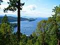
Mount Galiano is Galiano’s highest point, rising 311 metres (1020 feet) above sea level. The summit provides hikers with views over the Gulf Islands, the U.S. San Juan Islands and the distant mainland mountains as well. Just west of Mt. Galiano is Sutil Mountain, an Ecological Reserve 290 meters (951 feet) above sea level, named after Capt. Galiano's flagship.
The western coast of the island (facing Trincomali Channel) is characterized by its unique sandstone formations and caves.
Ecology
Due to its mild climate, Galiano Island is home to a large variety of animals and plants. In a major flight path for migrating birds, Galiano has hundreds of bird species,[12] such as bald eagles, herons and cormorants. Off its shores are resident and transient populations of orca whales, seals, otters, sea lions as well as many other varieties of sea life. The island is also home to a large population of deer.
Many native tree species such as Arbutus trees, western red cedar and coastal douglas fir thrive on the island and can be found in abundance. While most of the Island has been logged in the years since European settlement, limited old growth forests still exist, for example on the southern side Bluffs Park.[13]
Climate
The climate of Galiano Island is classified as Warm-Summer Mediterranean (Csb) under the Köppen climate classification system, characterized by mild, wet winters and warm, dry summers. Similar to the other Gulf Islands, the rain shadow effect of the Olympic and Vancouver Island mountains, and the moderating effects of the ocean, are the dominant influences on the climate of Galiano Island. The combined effects of low precipitation, warm temperatures, and high number of sunshine hours often result in an annual moisture deficit on Galiano Island from mid-June to early October. This deficit can often reach drought conditions in areas of recent clearcuts and can result in an extreme forest fire hazard in the summer months.[14]
| Climate data for Galiano Island | |||||||||||||
|---|---|---|---|---|---|---|---|---|---|---|---|---|---|
| Month | Jan | Feb | Mar | Apr | May | Jun | Jul | Aug | Sep | Oct | Nov | Dec | Year |
| Average high °C (°F) | 6.3 (43.3) |
8.1 (46.6) |
10.1 (50.2) |
13.0 (55.4) |
16.4 (61.5) |
19.4 (66.9) |
21.9 (71.4) |
21.8 (71.2) |
18.8 (65.8) |
13.9 (57.0) |
9.5 (49.1) |
6.6 (43.9) |
13.8 (56.9) |
| Daily mean °C (°F) | 3.4 (38.1) |
4.6 (40.3) |
6.1 (43.0) |
8.5 (47.3) |
11.5 (52.7) |
14.5 (58.1) |
16.5 (61.7) |
16.4 (61.5) |
13.8 (56.8) |
9.8 (49.6) |
6.2 (43.2) |
3.7 (38.7) |
9.6 (49.3) |
| Average low °C (°F) | 0.5 (32.9) |
1.1 (34.0) |
2.1 (35.8) |
4.1 (39.4) |
6.7 (44.1) |
9.6 (49.3) |
11.2 (52.2) |
11.1 (52.0) |
8.9 (48.0) |
5.8 (42.4) |
2.9 (37.2) |
0.9 (33.6) |
5.4 (41.7) |
| Average precipitation mm (inches) | 153 (6.0) |
112 (4.4) |
90 (3.5) |
59 (2.3) |
45 (1.8) |
36 (1.4) |
24 (0.9) |
29 (1.1) |
47 (1.9) |
98 (3.9) |
165 (6.5) |
162 (6.4) |
1,020 (40.1) |
| Source: climate-data.org | |||||||||||||
Transportation

Galiano Island is accessible by vehicle via the BC Ferries terminal at Sturdies Bay, located on Active Pass. Vehicle and passenger ferry service runs from Tsawwassen (Vancouver) on the mainland and Swartz Bay (Victoria) on Vancouver Island most days of the year. Additionally, there are numerous inter-island ferries that connect the Gulf Islands, which are scheduled less frequently.
Moorage is available at several public wharves for boat traffic: Sturdies Bay, (walking distance to the Village), Montague Harbour, Whalers Bay and Retreat Cove. Private moorage is available at Montague Harbour Marina and the Galiano Oceanfront Inn (Sturdies Bay). Limited water taxi service to nearby islands like Saltspring is also availible out of Sturdies Bay and Montague Harbour.
Daily, regularly scheduled floatplane service is offered from Downtown Vancouver and the Vancouver International Airport through Seair Seaplanes to Montague Harbour. There is regularly scheduled floatplane service from Seattle daily through Kenmore Air, either through Seattle-Tacoma International Airport, Kenmore Air Harbor and Seattle Lake Union.
Once on the Island, most areas can be accessed by paved road, however some logging roads remain in use in the less traveled sections of the Island.
Parks
Galiano is home to many popular public parks like Montague Harbour and Dionisio as well as privately owned parks such as Tapovan Peace Park.


- Montague Harbour Marine Provincial Park is one of the most popular parks in the Gulf Islands. It is unique for its Shell Beach, which is a west-facing beach with worn shells covering the whole expanse of the beach instead of sand. For thousands of years, it was the location of a midden used by Coast Salish people.[15] Montague Harbour is popular with the recreational boating community; the harbour is often crowded with yachts and sailboats during the warmer months of June, July, and August. The Park's mooring buoys are in limited supply and cannot be reserved, but the harbour is well sheltered if one chooses to anchor. A marina with moorage, gas dock, several small stores, and a cafe (summer only) is located at the southern end of the harbour. A public dock is near the marina.
- Dionisio Point Provincial Park is a boat-access only, rugged natural park at the north end of the island with beautiful beaches that the local islanders call Coon Bay. Here you will find a unique shoreline with sandstone formations, a sandy beach for swimming, tidal pools, colourful wildflowers, and forests that fill this beautiful provincial park.
- Bluffs Park is Galiano's oldest wilderness park, established by community subscription in 1948. With 130 ha (320 acres), it extends far inland into virgin forest, as well having high cliffs and a long sandy beach.
- Mount Galiano is Galiano’s highest point. It rises 314 meters (1030 feet) above sea level. The top provides hikers with views over the Gulf Islands, the U.S. San Juan Islands and the distant mainland mountains as well.
- Sutil Mountain in the southeastern part of the island is an Ecological Reserve 290 meters (951 feet) above sea level, named after Capt. Galiano's flagship.
- Collinson Point Provincial Park is essentially the shoreline of Mount Galiano, and is important in protecting the marine life of the approaches to Active Pass.
- Bodega Ridge Provincial Park consists of a ridge that rises over 240 metres above sea level, with views over many of the Gulf Islands' hundreds of islands and islets and beyond to the mountains of the Olympic Peninsula. High cliffs are home to raptors like peregrine falcons and bald eagles, as well as trees like cedars and Douglas fir.
- Tapovan Peace Park is a Tapovan of some 200 acres in the middle of the Island, dedicated to Sri Chinmoy. It features many hiking trails named by the word "peace", each in a different language, and a veritable stairway to heaven ascending the high cliff.
- Matthews Point Park is a 25-hectare Capital Regional District Park that preserves over a kilometre of waterfront on Active Pass, of which 300 metres are broad sandy beach. It was named after a pioneer family whose descendants in England later contributed towards the Park purchase. There is also a hiking loop along the clifftops.[16] It adjoins and is connected to Bluffs Park.
- The Trincomali Nature Sanctuary is an area of sheer cliffs that has been set aside by the Islands Trust for the preservation of Double-crested cormorants and Peregrine Falcons, among other species.
Government
Government bodies that oversee the island include Federal, Provincial and the Capital Regional District as well as the Islands Trust whose mandate is to establish land-use bylaws to "preserve and protect" the island, most notably in terms of development. For most of the twentieth century roughly half of the land on Galiano was owned by the logging firm MacMillan Bloedel. As a result, Galiano was not as extensively developed as neighboring islands. When the firm sold its holdings on Galiano, debate about development issues sharpened, and the Islands Trust set minimum lot sizes to limit development.
Local elections are held every three years to determine who will be the island's two Trustees.
There is one Indian Reserve on the island, Galiano Indian Reserve No. 9, located at the northern tip of the island operating under Penelakut administration.[17][18]
Tourism
Due to the minimal development of Galiano, tourism on the island has remained limited and sustainable. There are two proper hotels and several cabin resorts, but most accommodation comes in the form of Bed and Breakfasts, the Montague Provincial Park Campsite or holiday rentals. Activities on Galiano Island include hiking, boating, visiting art galleries, golfing and exploring beaches, as well as frequent musical events.
Infrastructure
The powerline HVDC Vancouver-Island crosses Galiano Island in southwestly direction as overhead powerline section, which ends at a cable terminal on Parker Island.
Notable people
Gallery
 Montague Harbour
 View from Mt. Galiano (late winter)
 Montague Harbour sunset in summer
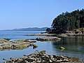 Dionsio Marine Provincial Park
Further reading
- Women in Fish Rosemary Georgeson & Marie Clements
- Historical Charcoal Pit Kilns British Columbia Museums Association, Roundup Magzine #271, p. 16
- Relacion del Viage de las Goletas Sutil y Mexicana Dionisio Alcala Galiano, Madrid, 1802. En la Imprenta Real. De Orden del Rey.
- Galiano Archives Local history, back numbers of local paper etc.
See also
References
- Census Profile, 2016 Census - Galiano Island Trust Area, Island trust Designated place, British Columbia and Alberta Province
- "Population and dwelling counts, for Canada, provinces and territories, and designated places, 2016 census". 2.statcan.ca. 2008-05-11. Retrieved 2011-11-20.
- "Galiano Island". BC Geographical Names.
- "Asociación Cultural Dionisio Alcalá-Galiano - Inicio". Alcalagaliano.com. Archived from the original on 2011-12-28. Retrieved 2011-11-20.
- "Galiano Island: A Historical Sketch". galianomuseum.ca. Retrieved 2020-03-19.
- "Smallpox in Canada".
- Kendrick, John (1990). The Voyage of Sutil and Mexicana, 1792: The last Spanish exploration of the Northwest Coast of America. Spokane, Washington: The Arthur H. Clark Company. pp. 43, 51–52, 208–209.
- "Japanese Charcoal Pit Kiln".
- "Dance at the Hall".
- Griffiths, Margaret. "The Story of Galiano Island: across thirty important years".
- "Macmillan Bloedel Ltd. v. Galiano Island Trust Committee".
- "Galiano Island Check List". iNaturalist.ca. 2009-07-29. Retrieved 2019-10-09.
- Emmings, Kate; Erickson, Keith (June 2004). Galiano Island Landscape Classification and Up-close Workshop Series Final Report (PDF) (Report). Galiano Conservancy Association.
- "Vanilla Leaf Land Nature Reserve (DL 58) Galiano Island Management Plan" (PDF).
- "Galiano Island". The Canadian Encyclopedia. 2014-01-23. Retrieved 2019-10-09.
- CRD, Matthews Point Management Plan https://www.crd.bc.ca/docs/default-source/parks-pdf/matthews-point-management-plan-2018.pdf?sfvrsn=1c13f6ca_4
- "Galiano Indian Reserve 9". BC Geographical Names.
- Indian and Northern Affairs Canada, Reserve/Settlement/Village Detail Archived 2012-05-15 at the Wayback Machine
External links
| Wikimedia Commons has media related to Galiano Island. |
| Wikivoyage has a travel guide for Galiano Island. |
- Galiano Island Chamber of Commerce incl. Island Information and Map
- Galiano Trails Society (with maps)
- Galiano Island on www.britishcolumbia.com
- Galiano Museum
- Tourism BC | Galiano Island
| Authority control |
|
|---|