Quadra Island
Quadra Island is an island off the eastern coast of Vancouver Island, British Columbia, Canada, part of the Discovery Islands located within the Strathcona Regional District. Quadra Island is about 35 kilometres (22 miles) from its northernmost point to its southernmost point. The island at its narrowest point, on its southern peninsula, is less than 2 km (1.24 mi) wide, and at its widest point, about 15 km (9 mi) wide. Quadra island is about 310 square kilometres (120 square miles) in area.
 Quadra Island is located at the northern end of the Strait of Georgia. | |
| Geography | |
|---|---|
| Location | Strait of Georgia |
| Coordinates | 50°10′N 125°14′W |
| Archipelago | Discovery Islands |
| Area | 310 km2 (120 sq mi) |
| Administration | |
| Province | British Columbia |
| Demographics | |
| Population | 2,472 (2006) |
| Ethnic groups | Laich-kwil-tach |
The population of island and surrounding mainland inlets, as of the 2006 federal census (excluding First Nations Reserves, tallied separately), was 2,472, down from the 2001 federal census count of 2,548. A more recent report (2017) suggest an estimated population of 4,000, with most at the southern end of the island, and states that many are "involved in the arts, fishing, logging, and tourism".[1]
Quadra Island is separated from Vancouver Island by Discovery Passage, and from Cortes Island by Read Island and the Sutil Channel, and is linked to that island by a ferry from Heriot Bay on its eastern shore. The island has many beaches, trails, lakes, and parks. Main Lake Provincial Park is located on the northern part of the island, and Rebecca Spit Marine Provincial Park is on the eastern shore, near Heriot Bay.
Few of the island's soils are well suited to agriculture. Most are coarse and, in well-drained areas, have classic podzol profile development; they are mapped as Kye loamy sand and Quinsam gravelly sandy loam. A small area of dark well-drained unpodzolized soil (Lazo loamy sand) is mapped around the southeast corner. Dashwood gravelly loamy sand, a brown podzolic trending to podzol, is commonly associated with Kye and Quinsam. Imperfectly drained areas have brown podzolic Bowser loamy sand or classic podzol Sayward loamy sand. The more moist Custer loamy sand, a groundwater podzol, is present locally. Poorly drained areas have Arrowsmith peat, Parksville sandy loam, or Tolmie loam (the latter two are gleysols).[2]
In spite of this, many residents have very successful home gardens, and the island boasts a well attended Garden Club and a bi-annual Quilt and Garden Tour.

There is an elementary school on the island. Schoolchildren in grades 6–12 travel by ferry to Campbell River to attend École Phoenix Middle School or Carihi Secondary School. The Cape Mudge Reserve on the southern tip of the island is home to the We-wai-kai, one of the main bands comprising the Southern Kwakiutl (the other being the We-wai-kum nation|We-wai-kum based in Campbell River on Vancouver Island). Together they are known as the Laich-kwil-tach (historically known as the Euclataws or Yucultas, names more familiar to speakers of British Columbia English).
The Nuyumabalees Cultural Centre is located within the Cape Mudge Village. The Centre opened in 1987 to hold the Sacred Potlatch Collection which was returned by the Federal Government. The Centre continues its efforts in "researching, locating and repatriating potlatch artifacts" from other sources around the world, according to a local report.[3][4]
The Southern Kwakiutl (part of the larger Kwakwaka'wakw ethnic grouping) migrated into the northern Georgia Strait from Queen Charlotte Strait over two centuries ago, displacing and absorbing the Comox and Pentlatch peoples who formerly lived there.[5]
Regional history
In 1903 the island was named after the Peruvian Spanish navigator Juan Francisco de la Bodega y Quadra, who explored and settled the Vancouver Island area in the late 18th century.[6]
In fact, the entire area, including Vancouver Island, was claimed by Spain in the 1700s. A settlement was not successfully negotiated and ownership of the island remained in dispute between Britain and the Spain in the early 1790s. The two countries nearly began a war over the issue; the confrontation became known as the Nootka Crisis. That was averted when both agreed to recognize the other's rights to the area in the first Nootka Convention in 1790, a first step to peace.[7] Finally, the two countries signed the second Nootka Convention in 1793 and the third Convention in 1794. As per that final agreement, the Spanish dismantled their fort on Vancouver Island and left the area, giving the British sovereignty overall of the islands (including the Gulf Islands).[8]
In 1846, the Oregon Treaty was signed by the British and the U.S. to settle the question of the U.S. Oregon Territory borders.[9] The Treaty made the 49th parallel latitude north the official border between the two countries. In order to ensure that Britain retained all of Vancouver Island and the Gulf Islands, it was agreed that the border would swing south around that area.[10]
The Coast Salish inhabited Quadra Island when Captain George Vancouver visited and wrote about their village at Cape Mudge in 1792; he described long houses, boats and a population of roughly 300 people. The Salish were driven out by other First Nations in the late 1800s.[11]
B.C. historian Jeanette Taylor states that "the We-Wai-Kai, with roots to the north among the Kwakwaka’wakw, took over the island through a complex process of both warfare and intermarriage". They fished for salmon year-round. The We-Wai-Kai band of the Kwagiulth live in Cape Mudge today. According to the historian, they "were prohibited from buying alcohol and barred by the government from the mechanized fishing fleet until 1926. Even their ceremonial gatherings – potlatches – were made illegal". In 1922, after mass arrests, the We-Wai-Kai people surrendered their masks and regalia to the government. The property was not returned to them for some 50 years, to the Nuuyumbalees Cultural Centre.[12]
The first school was built by the Kwagiulth people at Cape Mudge in 1893; the fishing fleet in operation at that time is still successful today. A copper and gold mine, the Lucky Jim, opened in 1903 but was destroyed by fire in 1941. In 1904, the island had "two post offices, a school, hotel, lumber camps, mills, and a mission", according to one report. A passenger ferry commenced service in 1949 and a ferry for vehicles started in 1960.
By 1904, Quadra had two post offices, a school, hotel, lumber camps, mills, and a mission. Severe fires devastated Quadra over the years leading to a poor economy well into the 1930s. A passenger ferry started in 1949 and a car ferry in 1960.[13]
Quadra today
.jpg)
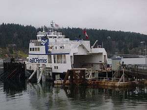
The BC Ferry terminal is located Quathiaski Cove on the island. The ferry runs from Vancouver to Campbell River on the mainland and on to Quadra Island, 10 minutes from Campbell River. Each day, the ferries make 18 round trips. Taxi service is available on the island. Flights from Vancouver stop at Campbell River and District Airport (YBL).[14][15]
A recent report about Cape Mudge Village (Yaculta) states that "the territory of the Kwa'Kwa'Ka' Wa'Kw Nation includes territory between a line running from Cape Mudge, Quadra Island to the mouth of Bute Inlet northward to Smith Inlet and around Vancouver Island to Quatsino Sound". The report adds that today, the We Wai Kai band of the Laichwiltach People "are a prosperous people involved with several major concerns in nearby Campbell River and on Quadra Island ... [they operate] a full service resort Tsa-Kwa-Luten Lodge & RV Park".[16] The other two main villages are Quathiaski Cove, the island's commercial hub, and Heriot Bay a picturesque community.
Tourists are welcome on the island. Quadra Island Chamber of Commerce works with local businesses to provide information for visitors, as part of the Discovery Islands Chamber of Commerce and also working with their partners on Cortes Island. [17]
Amenities include boat ramps, hiking trails, mountain bike trails, golf course, places to run, campgrounds, great road cycling, beaches, a freshwater lake chain for canoe tripping and hiking trails, according to Discovery Island Publishing. Boaters find "surging tidal rapids, large open bodies of water, numerous islets dotting the intricate shoreline, HMCS Columbia artificial reef ..." The annual Quadra Rocks Outdoor Festival is held each June. The Quadra Island Farmers' Market is open Saturday from May until September in Quathiaski Cove and indoors from October until April at the Quadra Island Community Centre. A local food market operates on the first Sunday of each month at the Quadra Island Legion in Heriot Bay.[18]
Sport fishermen are also drawn to the island for salmon and freshwater species.[19]
Accommodations are available in "oceanside resorts and lodges, quaint seaside houses and cottages for vacation rentals, rustic hostels".[20]
Many services are available at nearby Campbell River but Quadra has some too, according to the Discovery Island publication: a bank, ATMs, auto and marine repair services, a gas station (without automotive diesel), marine gas and diesel, cafes, restaurants, library, medical clinic, pharmacy, book store, groceries, an elementary school, childcare, RCMP detachment, real estate agents, hardware store, adventure tour operators and more.[21][22]
References
- "Out and About Quadra Island". Greater Victoria. Retrieved 13 January 2020.
- Day, J.H.; L. Farstad; D.G. Laird (1959). "Soil Survey of Southeast Vancouver Island and Gulf Islands, British Columbia". Department of Agriculture.
- "Cape Mudge Village". Discovery Islands Publishing. Retrieved 13 January 2020.
- Mauzé, Marie (2003) Two Kwakwaka'wakw Museums: Heritage and Politics. Ethnohistory, Vol.50, No.3: 503-522.
- MacLeod, William Christie (1925) Debtor and Chattel Slavery in Aboriginal North America. New Series, Vol. 27, No. 3:370-380.
- Akrigg, G. Philip V.; Akrigg, Helen B. (1997). British Columbia place names. UBC Press. p. 219. ISBN 978-0-7748-0637-4. Retrieved 4 April 2013.
- "Vancouver Island History". Discover Vancouver Island. Retrieved 13 January 2020.
- "Early European Exploration in Nootka Sound". Get West. 19 March 2011. Retrieved 13 January 2020.
- "Places". Our History. Hbc Heritage. Archived from the original on 2004-12-06. Retrieved 2008-03-08.
- "Britain and the United States agree on the 49th parallel as the main Pacific Northwest boundary in the Treaty of Oregon on June 15, 1846". History Link. 13 July 2013. Retrieved 13 January 2020.
- "Quadra Island History". Gulf Island Guide. Retrieved 13 January 2020.
- "Quadra Island History - A Turbulent Past". Discovery Islands Chamber of Commerce. Retrieved 13 January 2020.
Jeanette Taylor is the author of several books on the history of the region
- "Quadra Island History". Gulf Island Guide. Retrieved 13 January 2020.
- Travel to Quadra Island
- Campbell River to Quadra Island
- "Cape Mudge Village". Discovery Islands Publishing. Retrieved 13 January 2020.
- "Quadra Island Tourism". Chamber of Commerce. Retrieved 13 January 2020.
- "Quadra Island Simply Paradise". Discovery Islands Publishing. Retrieved 13 January 2020.
- "Out and About Quadra Island". Greater Victoria. Retrieved 13 January 2020.
- "Quadra Island Simply Paradise". Discovery Islands Publishing. Retrieved 13 January 2020.
- "Quadra Island Simply Paradise". Discovery Islands Publishing. Retrieved 13 January 2020.
- "Map of Quadra Island, Local Services". Discovery Islands Publishing. Retrieved 13 January 2020.
External links
| Wikimedia Commons has media related to Quadra Island. |
| Wikivoyage has a travel guide for Quadra Island. |