Groyne
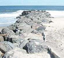
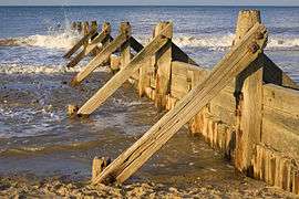
A groyne (in the U.S. groin), built perpendicular to the shore, is a rigid hydraulic structure built from an ocean shore (in coastal engineering) or from a bank (in rivers) that interrupts water flow and limits the movement of sediment. It is usually made out of wood, concrete or stone. In the ocean, groynes create beaches, prevent beach erosion caused by longshore drift where this is the dominant process and facilitate beach nourishment. There is also often cross shore movement which if longer than the groyne will limit its effectiveness.

Ocean groynes run generally perpendicular to the shore, extending from the upper foreshore or beach into the water. All of a groyne may be under water, in which case it is a submerged groyne. They are often used in tandem with seawalls and other coastal engineering features. Groynes, however, may cause a shoreline to be perceived as unnatural. Groynes are generally straightline but could be of various planview shapes, permeable or impermeable, built from various materials such as wood, sand, stone rubble or gabian, etc.
In a river, groynes slow down the process of erosion and prevent ice-jamming, which in turn aids navigation.
Background
Etymology
The term "groyne" is derived from the Old French groign, from Late Latin grunium, "snout".[1]
History
In 1720s, first wooden groyne was built to protect Brighton's coatline. In 1867, first concrete groyne was built in East Street and it is a free promanade of 195 ft length.
Mechanics
Beach evolution and sadimentation accretion
A groyne gradually creates and maintains a wide area of beach on its updrift side by trapping the sediments suspended in the ocean current, this processes is called accretion of sand and gravel or beach evolution. It reduces erosion on the other downdrift side by reducing the speed and power of the waves striking the shore. It is a physical barrier to stop sediment transport in the direction of longshore drift (also called longshore transport). If a groyne is correctly designed, then the amount of material it can hold will be limited, and excess sediment will be free to move on through the system. However, if a groyne is too large it may trap too much sediment, which can cause severe beach erosion on the down-drift side.
Groyne fields
Groynes are generally placed in series, generally all perpendicular to the shore. The areas between groups of groynes are groyne fields.
Terminal groyne syndrome
A poorly designed groyne (too long and not suited to the unique features of the coast) can also accelerate the erosion of the downdrift beach, which receives little or no sand from longshore drift. This process is known as terminal groyne syndrome, because in a series of groynes it occurs after the terminal groyne (last groyne on the downdrift side of the beach or coastline).
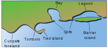
Headland groyne / Headland breakwater
Breakwater is a manmade offshore structure built parallel to the shore and remains unattached to the shore, when groyne is built to attach the breakwater to shore it is called "headland groyne", "bulkhead groyne", "headland breakwater", "T-head groyne" or "T-shaped groyne". Breakwater, which is a manmade structure, is similar to the naturally formed barrier island.
Usage
Coastal management
A groyne's length and elevation, and the spacing between groynes is determined according to local wave energy and beach slope. Groynes that are too long or too high tend to accelerate downdrift erosion, and are ineffective because they trap too much sediment. Groynes that are too short, too low, or too permeable are ineffective because they trap too little sediment. If a groyne does not extend far enough landward, water (for example at a high tide combined with a storm surge) may flow past the landward end and erode a channel bypassing the groyne, a process known as flanking.
River management
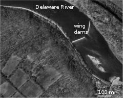
River groynes (spur dykes, wing dykes, or wing dams) are often constructed nearly perpendicular to the riverbanks, beginning at a riverbank with a root and ending at the regulation line with a head. They maintain a channel to prevent ice jamming, and more generally improve navigation and control over lateral erosion, that would form from meanders. Groynes have a major impact on the river morphology: they cause autonomous degradation of the river.[2]
They are also used around bridges to prevent bridge scour.
Types

Groynes can be distinguished by how they are constructed, whether they are submerged, their effect on stream flow or by shape.[3]
By their planview shape
Groynes can be built with different planview shapes. Some examples include straight groynes, hockey stick or curved, inverted hockey stick groynes, tail or checkmark shaped groynes, L head, straight groynes with pier head (seaward end raised on the stilts, since the pier head is raised on the stilts it does not act as the breakwater), T-head (headland groyne, breakwater attached to the shore with straight groyne, the head/breakwater itself could be shaped straight, Y-shaped, arrow or wing shaped head).
By the cross-section based on material used
Wooden groynes, sheetpile groynes, sand filled bags groynes, rubbble mound or gabion groynes, etc.
By permeability
Groynes can be permeable, allowing the water to flow through at reduced velocities, or impermeable, blocking and deflecting the current.
- Permeable groynes are large rocks, bamboo or timber
- impermeable groynes (solid groynes or rock armour groynes) are constructed using rock, gravel, gabions.
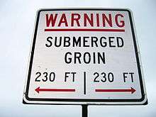
By whether they are submerged
Groynes can be submerged or not under normal conditions. Usually impermeable groynes are non-submerged, since flow over the top of solid groynes may cause severe erosion along the shanks. Submerged groynes, on the other hand, may be permeable depending on the degree of flow disturbance needed.
By their effect on stream flow
Groynes can be attracting, deflecting or repelling.
- Attracting groynes point downstream, serving to attract the stream flow toward themselves and not repel the flow toward the opposite bank. They tend to maintain deep current close to the bank.
- Deflecting groynes change the direction of flow without repelling it. They are generally short and used for limited, local protection.
- Repelling groynes point upstream; they force the flow away from themselves. A single groyne may have one section, for example, attracting, and another section deflecting.
Gallery
 Groyne on the east coast of England
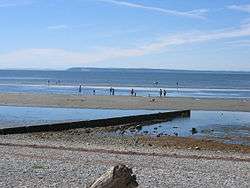 Groyne in Crescent Beach, British Columbia, Canada
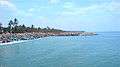
 Groynes off the Ennore Expressway near Chennai, India
 A groyne at Cortez Beach on Anna Maria Island, Florida at sunset
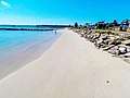 Groyne at Silver Beach, Sydney, Australia
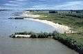
 A 1200-metre-long mole at Aramoana (centre left of image), protects the mouth of New Zealand's Otago Harbour
See also
- Beach erosion and accretion
- Beach nourishment
- Modern recession of beaches
- Raised beach
- Strand plain
- Integrated coastal zone management
- Coastal management, to prevent coastal erosion and creation of beach
- Coastal and oceanic landforms
- Coastal development hazards
- Coastal erosion
- Coastal geography
- Coastal engineering
- Coastal morphodynamics
- Coastal and Estuarine Research Federation (CERF)
- Longshore drift
- Deposition (sediment)
- Coastal sediment supply
- Sand dune stabilization
- Submersion
References
Citations
- "Groyne | Meaning of Groyne by Lexico". Lexico Dictionaries | English.
- Yossef (2005)
- Przedwojski et al. (1995)
Notes
- Construction Industry Research and Information Association (1990) Groynes in coastal engineering : data on performance of existing groyne systems, CIRIA technical note 135, London : CIRIA, ISBN 0-86017-314-3
- Crossman, M. and Simm, J. (2004) Manual on the use of timber in coastal and river engineering, HR Wallingford, London : Thomas Telford, ISBN 0-7277-3283-8
- French, P.W. (2001) Coastal defences : processes, problems and solutions, London : Routledge, ISBN 0-415-19844-5
- Hoyle, J.W. and King, J.T. (1971) The principles of coast protection, Lyndhurst : the authors, ISBN 0-903015-00-5
- Przedwojski, B., Błażejewski, R and Pilarczyk, K.W. (1995) River training techniques : fundamentals, design and applications, Rotterdam : Balkema, ISBN 90-5410-196-2
- Walker, D.J. (1987) Nearshore hydrodynamics and the behaviour of groynes on sandy beaches, PhD thesis, Imperial College London, 277 p.
- Yossef, M.F.M. (2005). Morphodynamics of rivers with groynes (Thesis). Delft University Press. ISBN 90-407-2607-8. Also published in the Delft Hydraulics Select Series (No. 7/2005).
External links
| Wikimedia Commons has media related to Groynes. |
- Groynes in the Netherlands
- Channel Coastal Observatory - Groynes
- Yossef, M. F. M. (2002). The Effect of Groynes on Rivers - Literature review (Report). Delft Cluster.
- Coastal Wiki portal
| Management |  | |
|---|---|---|
| Hard engineering | ||
| Soft engineering |
| |
| Related topics |
| |