Megatsunami
A megatsunami is a very large wave created by a large, sudden displacement of material into a body of water.
.png)
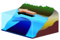
Megatsunamis have quite different features from other, more usual types of tsunamis. Most tsunamis are caused by underwater tectonic activity (movement of the earth's plates) and therefore occur along plate boundaries and as a result of earthquake and rise or fall in the sea floor, causing water to be displaced. Ordinary tsunamis have shallow waves out at sea, and the water piles up to a wave height of up to about 10 metres (33 feet) as the sea floor becomes shallow near land. By contrast, megatsunamis occur when a very large amount of material suddenly falls into water or anywhere near water (such as via a meteor impact), or are caused by volcanic activity. They can have extremely high initial wave heights of hundreds and possibly thousands of metres, far beyond any ordinary tsunami, as the water is "splashed" upwards and outwards by the impact or displacement. As a result, two heights are sometimes quoted for megatsunamis – the height of the wave itself (in water), and the "run-up," which is the height to which it surges when it reaches land, which, depending upon the locale, can be several times larger.
Modern megatsunamis include the one associated with the 1883 eruption of Krakatoa (volcanic eruption), the 1958 Lituya Bay megatsunami (landslide into a bay), and the wave resulting from the Vajont Dam landslide (caused by human activity destabilizing sides of valley). Prehistoric examples include the Storegga Slide (landslide), and the Chicxulub, Chesapeake Bay and Eltanin meteor impacts.
Overview
A megatsunami is a tsunami – a large wave due to displacement of a body of water – with an initial wave amplitude (height) measured in several tens, hundreds, or possibly thousands of metres.
Normal tsunamis generated at sea result from movement of the sea floor. They have a small wave height offshore, are very long (often hundreds of kilometres), and generally pass unnoticed at sea, forming only a slight swell usually of the order of 30 cm (12 in) above the normal sea surface. When they reach land, the wave height increases dramatically as the base of the wave pushes the water column above it upwards.
By contrast, megatsunamis are caused by giant landslides and other impact events. This could also refer to a meteorite hitting an ocean. Underwater earthquakes or volcanic eruptions do not normally generate such large tsunamis, but landslides next to bodies of water resulting from earthquakes can, since they cause a large amount of displacement. If the landslide or impact occurs in a limited body of water, as happened at the Vajont Dam (1963) and Lituya Bay (1958) then the water may be unable to disperse and one or more exceedingly large waves may result.
A way to visualize the difference, is that an ordinary tsunami is caused by sea floor changes, somewhat like pushing up on the floor of a large tub of water to the point it overflows, and causing a surge of water to "run-off" at the sides. In this analogy, a megatsunami would be more similar to dropping a large rock from a considerable height into the tub, at one end, causing water to splash up and out, and overflow at the other end.
Two heights are sometimes quoted for megatsunamis – the height of the wave itself (in water), and the height to which it surges when it reaches land, which depending upon the locale, can be several times larger.
Recognition of the concept of megatsunami
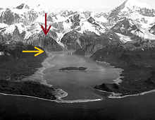
Geologists searching for oil in Alaska in 1953 observed that in Lituya Bay, mature tree growth did not extend to the shoreline as it did in many other bays in the region. Rather, there was a band of younger trees closer to the shore. Forestry workers, glaciologists, and geographers call the boundary between these bands a trim line. Trees just above the trim line showed severe scarring on their seaward side, whilst those from below the trim line did not. The scientists hypothesized that there had been an unusually large wave or waves in the deep inlet. Because this is a recently deglaciated fjord with steep slopes and crossed by a major fault, one possibility was a landslide-generated tsunami.[1]
On 9 July 1958, a 7.8 Mw strike-slip earthquake in southeast Alaska caused 90 million tonnes of rock and ice to drop into the deep water at the head of Lituya Bay. The block fell almost vertically and hit the water with sufficient force to create a wave that surged up the opposite side of the head of the bay to a height of 100 feet, and was still many tens of metres high further down the bay, when it carried eyewitnesses Howard Ulrich and his son Howard Jr. over the trees in their fishing boat. They were washed back into the bay and both survived.[1]
Analysis of mechanism
The mechanism giving rise to megatsunamis was analysed for the Lituya Bay event in a study presented at the Tsunami Society in 1999;[2] this model was considerably developed and modified by a second study in 2010.
Although the earthquake which caused the megatsunami was considered very energetic, and involving strong ground movements, several possible mechanisms were not likely or able to have caused the resulting megatsunami. Neither water drainage from a lake, nor landslide, nor the force of the earthquake itself led to the megatsunami, although all of these may have contributed.
Instead, the megatsunami was caused by a large and sudden impulsive impact when about 40 million cubic yards of rock several hundred metres above the bay was fractured from the side of the bay, by the earthquake, and fell "practically as a monolithic unit" down the almost vertical slope and into the bay.[2] The rockfall also caused air to be "dragged along" due to viscosity effects, which added to the volume of displacement, and further impacted the sediment on the floor of the bay, creating a large crater. The study concluded that:
The giant wave runup of 1,720 feet (524 m.) at the head of the Bay and the subsequent huge wave along the main body of Lituya Bay which occurred on July 9, 1958, were caused primarily by an enormous subaerial rockfall into Gilbert Inlet at the head of Lituya Bay, triggered by dynamic earthquake ground motions along the Fairweather Fault.
The large mass of rock, acted as a monolith (thus resembling high-angle asteroid impact), struck with great force the sediments at bottom of Gilbert Inlet at the head of the bay. The impact created a large crater and displaced and folded recent and Tertiary deposits and sedimentary layers to an unknown depth. The displaced water and the displacement and folding of the sediments broke and uplifted 1,300 feet of ice along the entire front of the Lituya Glacier at the north end of Gilbert Inlet. Also, the impact and the sediment displacement by the rockfall resulted in an air bubble and in water splashing action that reached the 1,720 foot (524 m.) elevation on the other side of the head of Gilbert Inlet. The same rockfall impact, in combination with the strong ground movements, the net vertical crustal uplift of about 3.5 feet, and an overall tilting seaward of the entire crustal block on which Lituya Bay was situated, generated the giant solitary gravity wave which swept the main body of the bay.
This was the most likely scenario of the event – the "PC model" that was adopted for subsequent mathematical modeling studies with source dimensions and parameters provided as input. Subsequent mathematical modeling at the Los Alamos National Laboratory (Mader, 1999, Mader & Gittings, 2002) supported the proposed mechanism – as there was indeed sufficient volume of water and an adequately deep layer of sediments in the Lituya Bay inlet to account for the giant wave runup and the subsequent inundation. The modeling reproduced the documented physical observations of runup.
A 2010 model examined the amount of infill on the floor of the bay, which was many times larger than that of the rockfall alone, and also the energy and height of the waves, and the accounts given by eyewitnesses, concluded that there had been a "dual slide" involving a rockfall, which also triggered a release of 5 to 10 times its volume of sediment trapped by the adjacent Lituya Glacier, as an almost immediate and many times larger second slide, a ratio comparable with other events where this "dual slide" effect is known to have happened.[3]
List of megatsunamis
Prehistoric
- The asteroid linked to the extinction of dinosaurs, which created the Chicxulub crater in Yucatán approximately 66 million years ago, would have caused an over 100 metres (328 ft) tall megatsunami. The height of the tsunami was limited due to relatively shallow sea in the area of the impact; had the asteroid struck in the deep sea the megatsunami would have been 4.6 kilometres (2.9 mi) tall.[4] A more recent simulation of the global effects of the megatsunami showed initial wave height of 1.5 kilometres (0.93 mi), with later waves up to 100 metres (328 ft) in height in the Gulf of Mexico, and up to 14 metres (46 ft) in the North Atlantic and South Pacific.[5]
- A series of megatsunamis were generated by the bolide impact that created the Chesapeake Bay impact crater, about 35.5 million years ago.[6]
- During the Messinian the coasts of northern Chile were likely struck by various megatsunamis.[7]
- A megatsunami affected the coast of south–central Chile in the Pliocene as evidenced by the sedimentary record of Ranquil Formation.[8]
- The Eltanin impact in the southeast Pacific Ocean 2.5 million years ago caused a megatsunami that was over 200 metres (656 ft) high in southern Chile and the Antarctic Peninsula; the wave swept across much of the Pacific Ocean.
- The northern half of the East Molokai Volcano suffered a catastrophic collapse and likely megatsunami about 1.5 million years ago and now lies as a debris field scattered northward across the ocean bottom,[9] while what remains on the island are the highest sea cliffs in the world.[10]
- The existence of large scattered boulders in only one of the four marine terraces of Herradura Bay south of the Chilean city of Coquimbo has been interpreted by Roland Paskoff as the result of a mega-tsunami that occurred in the Middle Pleistocene.[11]
- A major collapse of the western edge of the Lake Tahoe basin, a landslide with a volume of 12.5 cubic kilometres (3.0 cu mi) which formed McKinney Bay between 21,000 and 12,000 years ago, generated megatsunamis/seiche waves with an initial height of probably about 100 m (330 ft) and caused the lake's water to slosh back and forth for days. Much of the water in the megatsunamis washed over the lake's outlet at what is now Tahoe City, California, and flooded down the Truckee River, carrying house-sized boulders as far downstream as the California-Nevada border at what is now Verdi, California.[12][13]
- In the North Sea, the Storegga Slide caused a megatsunami approximately 8,200 years ago.[14] It is estimated to have completely flooded the remainder of Doggerland.[15]
- Approximately 8,000 years ago, a large volcanic landslide off Mount Etna, Sicily caused a megatsunami which devastated the eastern Mediterranean coastline on three continents. Wave heights on the coast of Calabria are estimated to have reached a maximum of 40 metres (131 ft).[16]
Historic
c. 2000 BC: Réunion
- A landslide on Réunion island, to the east of Madagascar, may have caused a megatsunami.[17]
c. 1600 BC: Santorini
- The Thera volcano erupted, the force of the eruption causing megatsunamis which affected the whole Aegean Sea and the eastern Mediterranean Sea.
Modern
1731: Storfjorden, Norway
At 10:00 p.m. on January 8, 1731, a landslide with a volume of possibly 6,000,000 cubic metres (7,800,000 cu yd) fell from the mountain Skafjell from a height of 500 metres (1,600 ft) into the Storfjorden opposite Stranda, Norway. The slide generated a megatsunami 100 metres (328 ft) in height that struck Stranda, flooding the area for 100 metres (328 ft) inland and destroying the church and all but two boathouses, as well as many boats. Damaging waves struck as far as way as Ørskog. The waves killed 17 people.[18]
1756: Langfjorden, Norway
Just before 8:00 p.m. on February 22, 1756, a landslide with a volume of 12,000,000 to 15,000,000 cubic metres (16,000,000 to 20,000,000 cu yd) traveled at high speed from a height of 400 metres (1,312 ft) on the side of the mountain Tjellafjellet into the Langfjorden about 1 kilometre (0.6 mi) west of Tjelle, Norway, between Tjelle and Gramsgrø. The slide generated three megatsunamis in the Langfjorden and the Eresfjorden with heights of 40 to 50 metres (131 to 164 ft). The waves flooded the shore for 200 metres (660 ft) inland in some areas, destroying farms and other inhabited areas. Damaging waves struck as far away as Veøy, 25 kilometres (16 mi) from the landslide — where they washed inland 20 metres (66 ft) above normal flood levels — and Gjermundnes, 40 kilometres (25 mi) from the slide. The waves killed 32 people and destroyed 168 buildings, 196 boats, large amounts of forest, and roads and boat landings.[19]
1792: Mount Unzen, Japan
In 1792, Mount Unzen in Japan erupted, causing part of the volcano to collapse into the sea. The landslide caused a megatsunami that reached 100 metres (328 ft) high and killed 15,000 people in the local fishing villages.
1853–1854: Lituya Bay, Alaska
Sometime between August 1853 and May 1854, a megatsunami occurred in Lituya Bay in what was then Russian America. Studies of Lituya Bay between 1948 and 1953 first identified the event, which probably occurred because of a large landslide on the south shore of the bay near Mudslide Creek. The wave had a maximum run-up height of 120 metres (394 ft), flooding the coast of the bay up to 750 feet (229 m) inland.[20]
Ca. 1874: Lituya Bay, Alaska
A study of Lituya Bay in 1953 concluded that sometime around 1874, perhaps in May 1874, a megatsunami occurred in Lituya Bay in Alaska. Probably occurring because of a large landslide on the south shore of the bay in the Mudslide Creek Valley, the wave had a maximum run-up height of 80 feet (24 m), flooding the coast of the bay up to 2,100 feet (640 m) inland.[21]
1883: Krakatoa
The eruption of Krakatoa created pyroclastic flows which generated megatsunamis when they hit the waters of the Sunda Strait on 27 August 1883. The waves reached heights of up to 24 metres (79 feet) along the south coast of Sumatra and up to 42 metres (138 feet) along the west coast of Java.[22]
1905: Lovatnet, Norway
On January 15, 1905, a landslide on the slope of the mountain Ramnefjellet with a volume of 350,000 cubic metres (460,000 cu yd) fell from a height of 500 metres (1,640 ft) into the southern end of the lake Lovatnet in Norway, generating three megatsunamis of up to 40.5 metres (133 ft) in height. The waves destroyed the villages of Bødal and Nesdal near the southern end of the lake, killing 61 people — half their combined population — and 261 farm animals and destroying 60 houses, all the local boathouses, and 70 to 80 boats, one of which — the tourist boat Lodalen — was thrown 300 metres (328 yd) inland by the last wave and wrecked. At the northern end of the 11.7-kilometre (7.3 mi)-long lake, a wave measured at almost 6 metres (20 ft) destroyed a bridge.[23]
1905: Disenchantment Bay, Alaska
On July 4, 1905, an overhanging glacier — since known as the Fallen Glacier — broke loose, slid out of its valley, and fell 1,000 feet (305 m) down a steep slope into Disenchantment Bay in Alaska, clearing vegetation along a path 0.5 miles (0.8 km) wide. When it entered the water, it generated a megatsunami which broke tree branches 110 feet (34 m) above ground level 0.5 miles (0.8 km) away. The wave killed vegetation to a height of 65 feet (20 m) at a distance of 3 miles (5 km) from the landslide, and it reached heights of from 50 to 115 feet (15 to 35 m) at different locations on the coast of Haenke Island. At a distance of 15 miles (24 km) from the slide, observers at Russell Fjord reported a series of large waves that caused the water level to rise and fall 15 to 20 feet (5 to 6 m) for a half-hour.[24]
1934: Tafjorden, Norway
On April 7, 1934, a landslide on the slope of the mountain Langhamaren with a volume of 3,000,000 cubic metres (3,900,000 cu yd) fell from a height of about 730 metres (2,395 ft) into the Tafjorden in Norway, generating a three megatsunamis, the last and largest of which reached a height of between 62 and 63.5 metres (203 and 208 ft) on the opposite shore. Large waves struck Tafjord and Fjørå. The waves killed 23 people at Tafjord, where the last and largest wave was 17 metres (56 ft) tall and struck at an estimated speed of 160 kilometres per hour (99 mph), flooding the town for 300 metres (328 yd) inland and killing 23 people. At Fjørå, waves reached 13 metres (43 ft), destroyed buildings, removed all soil, and killed 17 people. Damaging waves struck as far as 50 kilometres (31 mi) away, and waves were detected at a distance of 100 kilometres (62 mi) from the landslide. One survivor suffered serious injuries requiring hospitalization.[25]
1936: Lovatnet, Norway
On September 13, 1936, a landslide on the slope of the mountain Ramnefjellet with a volume of 1,000,000 cubic metres (1,300,000 cu yd) fell from a height of 800 metres (2,625 ft) into the southern end of the lake Lovatnet in Norway, generating three megatsunamis, the largest of which reached a height of 74 metres (243 ft). The waves destroyed all farms at Bødal and most farms at Nesdal — completely washing away 16 farms — as well as 100 houses, bridges, a power station, a workshop, a sawmill, several grain mills, a restaurant, a schoolhouse, and all boats on the lake. A 12.6-metre (41 ft) wave struck the northern end of the 11.7-kilometre (7.3 mi)-long lake and caused damaging flooding in the Loelva River, the lake's northern outlet. The waves killed 74 people and severely injured 11.[23]
1936: Lituya Bay, Alaska
On October 27, 1936, a megatsunami occurred in Lituya Bay in Alaska with a maximum run-up height of 490 feet (149 m) in Crillon Inlet at the head of the bay. The four eyewitnesses to the wave in Lituya Bay itself all survived and described it as between 100 and 250 feet (30 and 76 m) high. The maximum inundation distance was 2,000 feet (610 m) inland along the north shore of the bay. The cause of the megatsunami remains unclear, but may have been a submarine landslide.[26]
1958: Lituya Bay, Alaska, US
On July 9, 1958, a giant landslide at the head of Lituya Bay in Alaska, caused by an earthquake, generated a wave that washed out trees to a maximum altitude of 520 metres (1,706 ft) at the entrance of Gilbert Inlet.[27] The wave surged over the headland, stripping trees and soil down to bedrock, and surged along the fjord which forms Lituya Bay, destroying two fishing boats anchored there and killing two people.[1]
1963: Vajont Dam, Italy
On October 9, 1963, a landslide above Vajont Dam in Italy produced a 250 m (820 ft) surge that overtopped the dam and destroyed the villages of Longarone, Pirago, Rivalta, Villanova and Faè, killing nearly 2,000 people.[28]
1980: Spirit Lake, Washington, US
On May 18, 1980, the upper 460 metres (1,509 feet) of Mount St. Helens collapsed, creating a landslide. This released the pressure on the magma trapped beneath the summit bulge which exploded as a lateral blast, which then released the pressure on the magma chamber and resulted in a plinian eruption.
One lobe of the avalanche surged onto Spirit Lake, causing a megatsunami which pushed the lake waters in a series of surges, which reached a maximum height of 260 metres (853 feet)[29] above the pre-eruption water level (~975 m asl/3,199 ft). Above the upper limit of the tsunami, trees lie where they were knocked down by the pyroclastic surge; below the limit, the fallen trees and the surge deposits were removed by the megatsunami and deposited in Spirit Lake.[30]
2015: Taan Fiord, Alaska, US
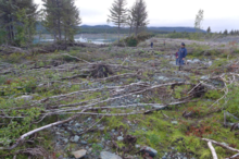
On October 17, 2015, the side of a mountain collapsed, at the head of Taan Fiord, a finger of Icy Bay in Alaska.[31][32][33] Some of the resulting landslide came to rest on the toe of Tyndall Glacier,[31][34] but about 180,000,000 short tons (161,000,000 long tons; 163,000,000 metric tons) of rock with a volume of about 50,000,000 cubic meters (65,400,000 cu yd) fell into the fjord.[33][31][35][36] The landslide generated a megatsunami with an initial height of initial height of about 100 meters (328 feet)[34][37] that struck the opposite shore of the fjord, with a run-up height there of 193 meters (633 feet).[31][32]
Over the next 12 minutes,[32] the wave traveled down the fjord at a speed of up to 60 miles per hour (97 km/h),[36] with run-up heights of over 100 meters (328 feet) in the upper fjord to 30 and 100 meters (98 and 328 feet) or more in its middle section, and 20 meters (66 feet) or more at its mouth.[31][32] Still probably 40 feet (12 meters) tall when it entered Icy Bay,[37] the tsunami inundated parts of Icy Bay′s shoreline with run-ups of 4 to 5 meters (13 to 16 feet) before dissipating into insigificance at distances of 5 kilometers (3.1 mi) from the mouth of Taan Fiord,[32] although the wave was detected 140 kilometers (87 miles) away.[31]
Occurring in an uninhabited area, the event was unwitnessed, and several hours passed before the signature of the landslide was noticed on seismographs at Columbia University in New York City.[32][38]
Potential future megatsunamis
In a BBC television documentary broadcast in 2000, experts said that they thought that a landslide on a volcanic ocean island is the most likely future cause of a megatsunami.[39] The size and power of a wave generated by such means could produce devastating effects, travelling across oceans and inundating up to 25 kilometres (16 mi) inland from the coast. This research was later found to be flawed.[40] The documentary was produced before the experts' scientific paper was published and before responses were given by other geologists. There have been megatsunamis in the past,[41] and future megatsunamis are possible but current geological consensus is that these are only local. A megatsunami in the Canary Islands would diminish to a normal tsunami by the time it reached the continents.[42] Also, the current consensus for La Palma is that the region conjectured to collapse is too small and too geologically stable to do so in the next 10,000 years, although there is evidence for past megatsunamis local to the Canary Isles thousands of years ago. Similar remarks apply to the suggestion of a megatsunami in Hawaii.[43]
British Columbia
Some geologists consider an unstable rock face at Mount Breakenridge, above the north end of the giant fresh-water fjord of Harrison Lake in the Fraser Valley of southwestern British Columbia, Canada, to be unstable enough to collapse into the lake, generating a megatsunami that might destroy the town of Harrison Hot Springs (located at its south end).[44]
Canary Islands
Geologists Dr. Simon Day and Dr. Steven Neal Ward consider that a megatsunami could be generated during an eruption of Cumbre Vieja on the volcanic ocean island of La Palma, in the Canary Islands, Spain.[45][46]
In 1949, this volcano erupted at its Duraznero, Hoyo Negro and Llano del Banco vents, and there was an earthquake with an epicentre near the village of Jedey. The next day Juan Bonelli Rubio, a local geologist, visited the summit area and found that a fissure about 2.5 kilometres (1.6 mi) long had opened on the east side of the summit. As a result, the west half of the volcano (which is the volcanically active arm of a triple-armed rift) had slipped about 2 metres (6.6 ft) downwards and 1 metre (3.3 ft) westwards towards the Atlantic Ocean.[47]
Cumbre Vieja is currently dormant, but will almost certainly erupt again. Day and Ward hypothesize[45][46] that if such an eruption causes the western flank to fail, a mega-tsunami could be generated.
La Palma is currently the most volcanically active island in the Canary Islands Archipelago. It is likely that several eruptions would be required before failure would occur on Cumbre Vieja.[45][46] The western half of the volcano has an approximate volume of 500 cubic kilometres (120 cu mi) and an estimated mass of 1.5 trillion metric tons (1.7×10¹² short tons). If it were to catastrophically slide into the ocean, it could generate a wave with an initial height of about 1,000 metres (3,300 ft) at the island, and a likely height of around 50 metres (164 ft) at the Caribbean and the Eastern North American seaboard when it runs ashore eight or more hours later. Tens of millions of lives could be lost in the cities and/or towns of St. John's, Halifax, Boston, New York, Baltimore, Washington, D.C., Miami, Havana and the rest of the eastern coasts of the United States and Canada, as well as many other cities on the Atlantic coast in Europe, South America and Africa.[45][46] The likelihood of this happening is a matter of vigorous debate.[48]
The last eruption on the Cumbre Vieja occurred in 1971 at the Teneguia vent at the southern end of the sub-aerial section without any movement. The section affected by the 1949 eruption is currently stationary and does not appear to have moved since the initial rupture.[49]
Geologists and volcanologists are in general agreement that the initial study was flawed. The current geology does not suggest that a collapse is imminent. Indeed, it seems to be geologically impossible right now, the region conjectured as prone to collapse is too small and too stable to collapse within the next 10,000 years.[40] They also concluded that a landslide is likely to happen as a series of smaller collapses rather than a single landslide from closer study of deposits left in the ocean by previous landslides. A megatsunami does seem possible locally in the distant future as there is geological evidence from past deposits suggesting that a megatsunami occurred with marine material deposited 41 to 188 meters above sea level between 32,000 and 1.75 million years ago.[41] This seems to have been local to Gran Canaria.
Day and Ward have admitted that their original analysis of the danger was based on several worst case assumptions.[50][51] A 2008 paper looked into this worst-case scenario, the most serious slide that could happen (though unlikely and probably impossible with present day geology). Although it would be a megatsunami locally in the Canary Isles, it would diminish in height to a regular tsunami when it reached the continents as the waves interfered and spread across the oceans.[42]
For more details see Cumbre Vieja criticism.
Cape Verde Islands
Steep cliffs on the Cape Verde Islands have been caused by catastrophic debris avalanches. These have been common on the submerged flanks of ocean island volcanoes and more can be expected in the future.[52]
Hawaii
Sharp cliffs and associated ocean debris at the Kohala Volcano, Lanai and Molokai indicate that landslides from the flank of the Kilauea and Mauna Loa volcanoes in Hawaii may have triggered past megatsunamis, most recently at 120,000 BP.[53][54][55] A tsunami event is also possible, with the tsunami potentially reaching up to about 1 kilometre (3,300 ft) in height[56] According to the documentary National Geographic's Ultimate Disaster: Tsunami, if a big landslide occurred at Mauna Loa or the Hilina Slump, a 30-metre (98 ft) tsunami would take only thirty minutes to reach Honolulu. There, hundreds of thousands of people could be killed as the tsunami could level Honolulu and travel 25 kilometres (16 mi) inland. Also, the West Coast of America and the entire Pacific Rim could potentially be affected.
Other research suggests that such a single large landslide is not likely. Instead, it would collapse as a series of smaller landslides.[57]
In 2018, shortly after the beginning of the 2018 lower Puna eruption, a National Geographic article responded to such claims with "Will a monstrous landslide off the side of Kilauea trigger a monster tsunami bound for California? Short answer: No."[43]
In the same article, geologist Mika McKinnon stated:[43]
there are submarine landslides, and submarine landslides do trigger tsunamis, but these are really small, localized tsunamis. They don't produce tsunamis that move across the ocean. In all likelihood, it wouldn't even impact the other Hawaiian islands.
Another volcanologist, Janine Krippner, added:[43]
People are worried about the catastrophic crashing of the volcano into the ocean. There's no evidence that this will happen. It is slowly—really slowly—moving toward the ocean, but it's been happening for a very long time.
Despite this, evidence suggests that catastrophic collapses do occur on Hawaiian volcanoes and generate local tsunamis.[58]
Norway
Although known earlier to the local population, a crack 2 metres (6.6 ft) wide and 500 metres (1,640 ft) in length in the side of the mountain Åkerneset in Norway was rediscovered in 1983 and attracted scientific attention. It since has widened at a rate of 4 centimetres (1.6 in) per year. Geological analysis has revealed that a slab of rock 62 metres (203 ft) thick and at an elevation stretching from 150 to 900 metres (490 to 2,950 ft) is in motion. Geologists assess that an eventual catastrophic collapse of 18,000,000 to 54,000,000 cubic metres (24,000,000 to 71,000,000 cu yd) of rock into Sunnylvsfjorden is inevitable and could generate megatsunamis of 35 to 100 metres (115 to 328 ft) in height on the fjord′s opposite shore. The waves are expected to strike Hellesylt with a height of 35 to 85 metres (115 to 279 ft), Geiranger with a height of 30 to 70 metres (98 to 230 ft), Tafjord with a height of 14 metres (46 ft), and many other communities in Norway′s Sunnmøre district with a height of several metres, and to be noticeable even at Ålesund. The predicted disaster is depicted in the Norwegian 2015 film The Wave.[59]
See also
- 2004 Indian Ocean earthquake and tsunami
- Cumbre Vieja
- La Palma
- List of historical tsunamis
- Minoan eruption
- Tsunamis in lakes
References
Footnotes
- Miller, Don J. "Giant Waves in Lituya Bay, Alaska". uwsp.edu. p. 3. Archived from the original on 13 October 2013.
- The Mega-Tsunami of July 9, 1958 in Lituya Bay, Alaska: Analysis of Mechanism – George Pararas-Carayannis, Excerpts from Presentation at the Tsunami Symposium of Tsunami Society of May 25–27, 1999, in Honolulu, Hawaii, USA
- Ward, Steven N.; Day, Simon (2010). "Lituya Bay Landslide and Tsunami — A Tsunami Ball Approach" (PDF). Journal of Earthquake and Tsunami. 4 (4): 285–319. doi:10.1142/S1793431110000893.
- Bryant, Edward (June 2014). Tsunami: The Underrated Hazard. Springer. p. 178. ISBN 978-3-319-06133-7.
- "Dinosaur-Killing Asteroid Created A Mile-High Tsunami That Swept Through The World's Oceans". iflscience.com. January 8, 2019.
- Poag, C. W. (1997). "The Chesapeake Bay bolide impact: A convulsive event in Atlantic Coastal Plain evolution". Sedimentary Geology. 108 (1–4): 45–90. Bibcode:1997SedG..108...45P. doi:10.1016/S0037-0738(96)00048-6.CS1 maint: ref=harv (link)
- Le Roux, Jacobus P. (2015). "A critical examination of evidence used to re-interpret the Hornitos mega-breccia as a mass-flow deposit caused by cliff failure". Andean Geology. 41 (1): 139–145.
- Le Roux, J.P.; Nielsen, Sven N.; Kemnitz, Helga; Henriquez, Álvaro (2008). "A Pliocene mega-tsunami deposit and associated features in the Ranquil Formation, southern Chile" (PDF). Sedimentary Geology. 203 (1): 164–180. Bibcode:2008SedG..203..164L. doi:10.1016/j.sedgeo.2007.12.002. Retrieved 11 April 2016.
- "Hawaiian landslides have been catastrophic". mbari.org. Monterey Bay Aquarium Research Institute. 2015-10-22.
- Culliney, John L. (2006) Islands in a Far Sea: The Fate of Nature in Hawaii. Honolulu: University of Hawaii Press. p. 17.
- Paskoff, Roland (1991). "Likely occurrence of mega-tsunami in the Middle Pleistocene near Coquimbo, Chile". Revista geológica de Chile. 18 (1): 87–91. Retrieved 17 July 2016.
- Gardner, J.V. (July 2000). "The Lake Tahoe debris avalanche". 15th Annual Geological Conference. Geological Society of Australia.
- Alden, Andrew, "The 'Tahoe Tsunami': New Study Envisions Early Geologic Event," kqed.org, July 31, 2014, Retrieved 23 June 2020
- Bondevik, S.; Lovholt, F.; Harbitz, C.; Mangerud, J.; Dawsond, A.; Svendsen, J. I. (2005). "The Storegga Slide tsunami—comparing field observations with numerical simulations". Marine and Petroleum Geology. 22 (1–2): 195–208. doi:10.1016/j.marpetgeo.2004.10.003.CS1 maint: ref=harv (link)
- Rincon, Paul (1 May 2014). "Prehistoric North Sea 'Atlantis' hit by 5m tsunami". BBC News. Retrieved 22 February 2017 – via www.bbc.com.
- Pareschi, M. T.; Boschi, E.; Favalli, M. (2006). "Lost tsunami". Geophysical Research Letters. 33 (22): L22608. Bibcode:2006GeoRL..3322608P. doi:10.1029/2006GL027790.CS1 maint: ref=harv (link)
- "Mega-tsunami: Wave of Destruction". BBC Two. 12 October 2000.
- Hoel, Christer, "The Skafjell Rock Avalanche in 1731," fjords.com Retrieved 23 June 2020
- Hoel, Christer, "The Tjelle Rock Avalanche in 1756," fjords.com Retrieved 22 June 2020
- Lander, pp. 39–41.
- Lander, pp. 44–45.
- Bryant, Edward, Tsunami: The Underrated Hazard, Springer: New York, 2014, ISBN 978-3-319-06132-0, pp. 162–163.
- Hoel, Christer, "The Loen Accidents in 1905 and 1936," fjords.com Retrieved 22 June 2020
- Lander, p. 57.
- Hoel, Christer, "The Tafjord Accident in 1934," fjords.com Retrieved 22 June 2020
- Lander, pp. 61–64.
- Mader, Charles L.; Gittings, Michael L. (2002). "Modeling the 1958 Lituya Bay Mega-Tsunami, II" (PDF). Science of Tsunami Hazards. 20 (5): 241–250.
- "Archived copy". Archived from the original on 2009-07-29. Retrieved 2009-07-29.CS1 maint: archived copy as title (link) Vaiont Dam photos and virtual field trip (University of Wisconsin), retrieved 2009-07-01
- Voight et al. 1983
- USGS Website. Geology of Interactions of Volcanoes, Snow, and Water: Tsunami on Spirit Lake early during 18 May 1980 eruption
- researchgate.net The 2015 Landslide and Tsunami in Taan Fiord, Alaska
- Higman, Bretwood, et. al., "The 2015 landslide and tsunami in Taan Fiord, Alaska," nature.com, September 6, 2018 Retrieved 16 June 2020
- nps,gov National Park Service, "Taan Fjord Landslide and Tsunami," nps.gov,Retrieved 16 June 2020
- Rozell, Ned, "The giant wave of Icy Bay," alaska.edu, April 7, 2016 Retrieved 16 June 2020
- Underwood, Emily, "Study of Alaskan Landslide Could Improve Tsunami Modeling," eos.org, April 26, 2019 Retrieved 16 June 2020
- Mooney, Chris, "One of the biggest tsunamis ever recorded was set off three years ago by a melting glacier," washingtonpost.com, September 6, 2018 Retrieved 16 June 2020
- Stolz, Kit, "Why Scientists Are Worried About a Landslide No One Saw or Heard," atlasobscura.com, March 17, 2017 Retrieved 16 June 2020
- Morford Stacy, "Detecting Landslides from a Few Seismic Wiggles," columbia.edu, December 18, 2015 Retrieved 16 June 2020
- "Mega-tsunami: Wave of Destruction". Transcript. BBC Two television programme, first broadcast. 12 October 2000.
- "New Research Puts 'Killer La Palma Tsunami' At Distant Future". Science Daily, based on materials from the Delft University of Technology. September 21, 2006.
- Pérez-Torrado, F. J; Paris, R; Cabrera, M. C; Schneider, J-L; Wassmer, P; Carracedo, J. C; Rodríguez-Santana, A; & Santana, F; 2006. Tsunami deposits related to flank collapse in oceanic volcanoes: The Agaete Valley evidence, Gran Canaria, Canary Islands. Marine Geol. 227, 135–149
- Løvholt, F., G. Pedersen, and G. Gisler. "Oceanic propagation of a potential tsunami from the La Palma Island." Journal of Geophysical Research: Oceans 113.C9 (2008).
- Sarah Gibbons (May 17, 2018). "No, Hawaii's Volcano Won't Trigger a Mega-Tsunami". National Geographic.
- Evans, S.G.; Savigny, K.W. (1994). "Landslides in the Vancouver-Fraser Valley-Whistler region" (PDF). Geological Survey of Canada. Ministry of Forests, Province of British Columbia. pp. 36 p. Retrieved 2008-12-28.
- Day et al. 1999
- Ward & Day 2001
- Bonelli 1950
- Pararas-Carayannis 2002
- As per Bonelli Rubio
- Ali Ayres (2004-10-29). "Tidal wave threat 'over-hyped'". BBC NEWS.
- Pararas-Carayannis, George (2002). "Evaluation of the threat of mega tsunami generation from postulated massive slope failures of the island volcanoes on La Palma, Canary Islands, and on the island of Hawaii" (PDF). Science of Tsunami Hazards. 20 (5): 251–277. Retrieved 7 September 2014.
- Le Bas, T.P. (2007). "Slope Failures on the Flanks of Southern Cape Verde Islands". In Lykousis, Vasilios (ed.). Submarine mass movements and their consequences: 3rd international symposium. Springer. ISBN 978-1-4020-6511-8.CS1 maint: ref=harv (link)
- McMurtry, Gary M.; Fryer, Gerard J.; Tappin, David R.; Wilkinson, Ian P.; Williams, Mark; Fietzke, Jan; Garbe-Schoenberg, Dieter; Watts, Philip (1 September 2004). "Megatsunami deposits on Kohala volcano, Hawaii, from flank collapse of Mauna Loa". Geology. 32 (9): 741. Bibcode:2004Geo....32..741M. doi:10.1130/G20642.1.CS1 maint: ref=harv (link)
- McMurtry, Gary M.; Fryer, Gerard J.; Tappin, David R.; Wilkinson, Ian P.; Williams, Mark; Fietzke, Jan; Garbe-Schoenberg, Dieter; Watts, Philip (September 1, 2004). "A Gigantic Tsunami in the Hawaiian Islands 120,000 Years Ago". Geology. SOEST Press Releases. Retrieved 2008-12-20.
- McMurtry, G. M.; Tappin, D. R.; Fryer, G. J.; Watts, P. (December 2002). "Megatsunami Deposits on the Island of Hawaii: Implications for the Origin of Similar Deposits in Hawaii and Confirmation of the 'Giant Wave Hypothesis'". AGU Fall Meeting Abstracts. 51: OS51A–0148. Bibcode:2002AGUFMOS51A0148M.CS1 maint: ref=harv (link)
- Britt, Robert Roy (14 December 2004). "The Megatsunami: Possible Modern Threat". LiveScience. Retrieved 2008-12-20.
- Pararas-Carayannis, George (2002). "Evaluation of the threat of mega tsunami generation from postulated massive slope failures of island volcanoes on La Palma, Canary Islands, and on the island of Hawaii". drgeorgepc.com. Retrieved 2008-12-20.
- "Megatsunami Deposits vs. High-stand Deposits in Hawi'i" (PDF). Earth Web. June 12–15, 2005.
- Hole, Christer, "The Åkerneset Rock Avalanche," fjords.com Retrieved 23 June 2020
Bibliography
- Lander, James F. Tsunamis Affecting Alaska 1737-1996. Boulder, Colorado: NOAA National Geophysical Data Center, September 1996.
Further reading
- BBC 2 TV; 2000. Transcript "Mega-tsunami; Wave of Destruction", Horizon. First screened 21.30 hrs, Thursday, 12 October 2000.
- Carracedo, J.C. (1994). "The Canary Islands: an example of structural control on the growth of large oceanic-island volcanoes". J. Volcanol. Geotherm. Res. 60 (3–4): 225–241. Bibcode:1994JVGR...60..225C. doi:10.1016/0377-0273(94)90053-1.CS1 maint: ref=harv (link)
- Carracedo, J.C. (1996). "A simple model for the genesis of large gravitational landslide hazards in the Canary Islands". In McGuire, W; Jones; Neuberg, J.P. (eds.). Volcano Instability on the Earth and Other Planets. Special Publication. 110. London: Geological Society. pp. 125–135.
- Carracedo, J.C. (1999). "Growth, Structure, Instability and Collapse of Canarian Volcanoes and Comparisons with Hawaiian Volcanoes". J. Volcanol. Geotherm. Res. 94 (1–4): 1–19. Bibcode:1999JVGR...94....1C. doi:10.1016/S0377-0273(99)00095-5.CS1 maint: ref=harv (link)
- Day, S.J.; Carracedo, J.C.; Guillou, H.; Gravestock, P. (1999). "Recent structural evolution of the Cumbre Vieja volcano, La Palma, Canary Islands: volcanic rift zone re-configuration as a precursor to flank instability" (PDF). J. Volcanol. Geotherm. Res. 94 (1–4): 135–167. Bibcode:1999JVGR...94..135D. CiteSeerX 10.1.1.544.8128. doi:10.1016/S0377-0273(99)00101-8.CS1 maint: ref=harv (link)
- Moore, J.G. (1964). "Giant Submarine Landslides on the Hawaiian Ridge". US Geologic Survey: D95–8. Professional Paper 501-D. Cite journal requires
|journal=(help)CS1 maint: ref=harv (link) - Pararas-Carayannis, G. (2002). "Evaluation of the Threat of Mega Tsunami Generation from Postulated Massive Slope Failure of Island Stratovolcanoes on La Palma, Canary Islands, and on The Island of Hawaii, George". Science of Tsunami Hazards. 20 (5): 251–277.CS1 maint: ref=harv (link)
- Pinter, N.; Ishman, S.E. (2008). "Impacts, mega-tsunami, and other extraordinary claims" (PDF). GSA Today. 18 (1): 37–38. doi:10.1130/GSAT01801GW.1. Archived from the original (PDF) on 2014-10-17. Retrieved 2008-03-06.CS1 maint: ref=harv (link)
- Rihm, R; Krastel, S. & CD109 Shipboard Scientific Party; 1998. Volcanoes and landslides in the Canaries. National Environment Research Council News. Summer, 16–17.
- Siebert, L. (1984). "Large volcanic debris avalanches: characteristics of source areas, deposits and associated eruptions". J. Volcanol. Geotherm. Res. 22 (3–4): 163–197. Bibcode:1984JVGR...22..163S. doi:10.1016/0377-0273(84)90002-7.CS1 maint: ref=harv (link)
- Vallely, G.A. (2005). "Volcanic edifice instability and tsunami generation: Montaña Teide, Tenerife, Canary Islands (Spain)". Journal of the Open University Geological Society. 26 (1): 53–64.CS1 maint: ref=harv (link)
- Voight, B.; Janda, R.; Glicken, H.; Douglas, P.M. (1983). "Nature and mechanics of the Mount St Helens rockslide-avalanche of 18 May 190". Géotechnique. 33 (10): 243–273. doi:10.1680/geot.1983.33.3.243.CS1 maint: ref=harv (link)
- Ward, S.N.; Day, S. (2001). "Cumbre Vieja Volcano — Potential collapse and tsunami at La Palma, Canary Islands" (PDF). Geophysical Research Letters. 28 (17): 3397–3400. Bibcode:2001GeoRL..28.3397W. doi:10.1029/2001GL013110.CS1 maint: ref=harv (link)
- Sandom, J.G., 2010, The Wave — A John Decker Thriller, Cornucopia Press, 2010. A thriller in which a megatsunami is intentionally created when a terrorist detonates a nuclear bomb on La Palma in the Canary Islands.
- Bonelli Rubio, J.M., 1950. Contribucion al estudio de la erupcion del Nambroque o San Juan. Madrid: Inst. Geografico y Catastral, 25 pp.
- Ortiz, J.R., Bonelli Rubio, J.M., 1951. La erupción del Nambroque (junio-agosto de 1949). Madrid: Talleres del Instituto Geográfico y Catastral, 100 p., 1h. pleg.;23 cm
External links
- Mega Tsunami: history, causes, effects
- World's Biggest Tsunami: The largest recorded tsunami with a wave 1720 feet tall in Lituya Bay, Alaska.
- Benfield Hazard Research Centre
- BBC — Mega-tsunami: Wave of Destruction BBC Two program broadcast 12 October 2000
- La Palma threat "over-hyped", BBC News, 29 October 2004
- Mega-hyped Tsunami story A detailed of analysis demolishing the La Palma Tsunami speculation.