Green Island, Hong Kong
Green Island (Chinese: 青洲) is an island off the northwest coast of Kennedy Town, Hong Kong Island, separated by the Sulphur Channel. A smaller island nearby to the east, uninhabited, is called Little Green Island (小青洲). Administratively, the two islands are part of Central and Western District.
 Green Island Lighthouse Compound | |||||||||||||||||
 Green Island Lighthouse Hong Kong | |||||||||||||||||

| |||||||||||||||||
| Location | Hong Kong | ||||||||||||||||
|---|---|---|---|---|---|---|---|---|---|---|---|---|---|---|---|---|---|
| Coordinates | 22.283799°N 114.111163°E | ||||||||||||||||
| Year first constructed | 1875 (first) | ||||||||||||||||
| Year first lit | 1905 (current) | ||||||||||||||||
| Construction | granite tower (both) | ||||||||||||||||
| Tower shape | cylindrical tower with balcony and lantern (current) cylindrical tower and lantern removed (first) | ||||||||||||||||
| Markings / pattern | white tower and lantern | ||||||||||||||||
| Tower height | 12 metres (39 ft) (first) 17.5 metres (57 ft) (current) | ||||||||||||||||
| Focal height | 37 metres (121 ft) (current) | ||||||||||||||||
| Original lens | 4th order Fresnel lens (first) | ||||||||||||||||
| Current lens | 1st order Fresnel lens | ||||||||||||||||
| Range | 16 nautical miles (30 km; 18 mi) | ||||||||||||||||
| Characteristic | Fl W 10s. | ||||||||||||||||
| Admiralty number | P3538 | ||||||||||||||||
| NGA number | 19460 | ||||||||||||||||
| ARLHS number | HOK-002 | ||||||||||||||||
| Hong Kong number | HK-069[1] | ||||||||||||||||
| Chinese name | |||||||||||||||||
| Chinese | 青洲 | ||||||||||||||||
| |||||||||||||||||
Buildings
Green Island is largely uninhabited and at the east coast is Green Island Reception Centre and Green Island Police Station. On the top of the hill is an office of the Marine Department and a lighthouse southwest guides the ships in Sulphur Channel.

Lighthouse compound
The buildings of the Green Island Lighthouse Compound were declared as monuments in 2008.[2] The historic buildings include the two lighthouses built in 1875 and 1905 and the European quarters of the lighthouse compound. These three buildings are individually Grade II historic buildings.[3]
The first lighthouse, 12 metres (39 ft) tall and constructed of granite, began operation on 1 July 1875. There are two cross-shaped openings on its wall for ventilation and lighting. The openings resemble gun-posts like those found in medieval European castles. These are of the same construction as those found on the Cape Collinson Lighthouse at Siu Sai Wan, Hong Kong Island.[4] It was later disused in 1905 because the building was too small to carry the lens from the Cape D'Aguilar Lighthouse.[5]
Construction began on a second lighthouse in 1904, completed in 1905, which was originally intended to house the Cape D’Aguilar light. Built of granite and concrete, sitting beside its predecessor, the newer lighthouse is 17.5 metres (57 ft) tall, painted white, with a steel-caged lantern on top. A concrete spiral staircase with rails gives access to the lantern room. An upper floor was added to the keeper's house in 1923 and the lighthouse was automated in the 1970s. The two lighthouses, along with Cape D'Aguilar Lighthouse, Waglan Island Lighthouse and Tang Lung Chau Lighthouse (Kap Sing Lighthouse) are the only prewar lighthouses remaining.[5]
Living quarters and house
The keeper’s house has a flat roof and is designed in an 'L' shape. The house has arched windows and hanging eaves.[5]
The quarters was converted to the Police Recreation Centre for an unknown time. It is currently leased to the Wu Oi Christian Centre as a youth drug treatment rehabilitation centre.[5]
Flora and fauna
The island is densely covered with woodland and tall scrub. A total of 150 plant species and a large variety of butterfly species has been found. One ant species not previously found elsewhere in Hong Kong was recorded on Green Island. The locally rare reef egret and white-bellied sea eagle have been seen on the island.
Air traffic
Green Island is an important reporting point for location aviation in Hong Kong for entry to Victoria Harbour by air. All local traffic flying into or out of the Harbour must report overhead Green Island. As the Harbour is quite narrow and aviation traffic can be heavy at times due to the large number of helicopters and light aircraft, Green Island can also act as a holding point before permission to enter is granted by air traffic control.
Reclamation
In the 1990s, the Hong Kong Government proposed reclaiming approximately 181 hectares of land from Sulphur Channel to provide accommodation for a population of 103,465 and more road infrastructure. This included a coastal highway from Kennedy Town to Aberdeen (then called Route 7) and a fourth cross-harbour tunnel to a proposed container port at North Lantau.[6] This proposal was shelved due to strong opposition from environmental concern groups.
See also
- List of lighthouses in China
- Waglan Lighthouse
- Cape D'Aguilar Lighthouse
- Tang Lung Chau Lighthouse
References
- Rowlett, Russ. "Lighthouses of China: Hong Kong". The Lighthouse Directory. University of North Carolina at Chapel Hill. Retrieved January 13, 2016.
- "Declared Monuments". www.amo.gov.hk.
- "List of Graded Historic buildings in Hong Kong (As at 16 May 2008)" (PDF). Archived from the original (PDF) on July 9, 2011.
- Cape Collinson Lighthouse- Retrieved 2016-06-04
- "Green Island Lighthouse Compound - Declared Monuments - Antiquities and Monuments Office". www.amo.gov.hk. Retrieved 2019-06-11.
- https://www.epd.gov.hk/eia/register/report-bc/eia046/eia046-es.pdf
Gallery
 Green Island and Little Green Island viewed from Hong Kong Island
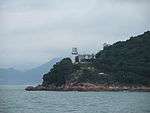 Green Island and its lighthouse
 Green Island and Little Green Island
External links
| Wikimedia Commons has media related to Green Island, Hong Kong. |
| Wikimedia Commons has media related to Little Green Island, Hong Kong. |
- Biodiversity of the island (WWF HK)
- "Review of Egretries in Hong Kong", in Hong Kong Biodiversity, Issue No. 14 March 2007, pp. 1-6.
- Aerial image from Google Map
- Ha, Louis; Waters, Dan (2001). "Hong Kong's Lighthouses and the Men Who Manned Them" (PDF). Journal of the Royal Asiatic Society Hong Kong Branch. 41: 281–320. ISSN 1991-7295.
- "Green Island Lighthouse". Hong Kong Memory. Retrieved 11 August 2018.