Causeway Bay
Causeway Bay (Chinese: 銅鑼灣) is a heavily built-up area of Hong Kong, located on Hong Kong Island, and covering parts of Wan Chai District. The Cantonese name is also romanised as Tung Lo Wan as in Tung Lo Wan Road (銅鑼灣道). The rent in the shopping areas of Causeway Bay was ranked as the world's most expensive for the second year in a row, after overtaking New York City's Fifth Avenue in 2012.[1]
| Causeway Bay | |||||||||||||||
|---|---|---|---|---|---|---|---|---|---|---|---|---|---|---|---|
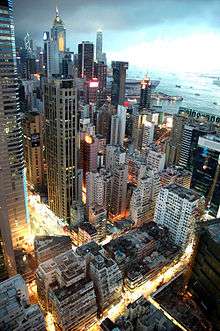 High-density buildings in Causeway Bay | |||||||||||||||
| Traditional Chinese | 銅鑼灣 | ||||||||||||||
| Simplified Chinese | 铜锣湾 | ||||||||||||||
| Cantonese Yale | Tùhnglòh wàahn | ||||||||||||||
| Literal meaning | "Copper Gong Bay" | ||||||||||||||
| |||||||||||||||
Location


Causeway Bay borders the Eastern District. Causeway Bay includes Tsing Fung Street, Causeway Bay market, the Victoria Park, the Royal Hong Kong Yacht Club, Jardine's Noonday Gun, the Police Officers Club, Queen's College and the Hong Kong Central Library. The western border of Causeway Bay is considered to be marked by Canal Road, which separates it from the Wan Chai area.
Since 1982, two electoral constituencies of Causeway Bay (Causeway Bay North and Causeway Bay South) had been grouped into the Eastern District of district board elections, whilst Causeway Bay Middle was grouped with the Wan Chai District to the west. However, local government decisions—other than electoral demarcations—still affect the region as a whole. Since 1994, Hong Kong district board elections have further been sub-divided into smaller constituencies . The northern sector consists of the area around Victoria Park, the middle sector coincides with the central business district, and the southern sector forms the area around Tin Hau.
To cope with population change, the constituency boundary between Wan Chai District and Eastern District was changed in the new year day of 2016 (effective on voting in 2019 Hong Kong local elections). As a result, the Victoria Park and Tin Hau became a part of Wan Chai District starting from that day. As a consequence, the whole of Causeway Bay is now part of Wan Chai District.[2]
In term of town planning, there is Causeway Bay Outline Zoning Plan,[3] which is not related to the electoral boundaries drawn by Electoral Affairs Commission.[2] The OZP also covers Tai Hang and So Kon Po,[3] which are another neighbourhoods. The OZP did not covers Victoria Park, which was reclamated from the Causeway Bay/Tung Lo Wan the water body. The OZP did not covers Tin Hau[3] which historically part of Tung Lo Wan, the Chinese name that collectively referred to the water and land area of the bay.
Causeway Bay Market and Causeway Bay Fire Station, named after the area, is in fact located in Tin Hau area outside the OZP. However, in term of electoral constituency, the market, the fire station and the Park are located in the Victoria Park constituency. To add more confusion, Wan Chai Fire Station is located in Canal Road constituency but some non-government source considered it is part of Causeway Bay area.[4] The Wan Chai Fire Station is not part of Causeway Bay OZP.[3]
History
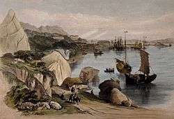
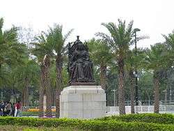
The typhoon shelter of Causeway Bay and the Tin Hau Temple reveal that the area was once a fishing village. Before urban development and massive land reclamation, Causeway Bay was a heavily silted bay. Its former shape can be found on maps by tracing Tung Lo Wan Road, which goes along the former bay. In the early stage of development a causeway was built, which is the present-day Causeway Road. In the 1950s, the coastline was further pushed forward when the remains of the bay was reclaimed for the Victoria Park, when the statue of Queen Victoria was brought back from Japan. The statue had been taken away during the Second World War from Statue Square at Chater Road, Central. Kellett Island off the coast of Causeway Bay has disappeared and connected as a result of the land reclamation.
The original Causeway Bay proper is actually the area now known as Tin Hau, near the present-day Tin Hau MTR station and the Causeway Bay Tin Hau Temple, whereas the Causeway Bay MTR station is at the area historically called East Point.
The present-day usage of the name Causeway Bay is usually confused with East Point, an area named after a spit on the coastline, eastern end of formerly Victoria City. The names of Yee Wo Street, Jardine's Bazaar and Jardine's Crescent reveal that the land in this area was sold by the British colonial government to Jardines in the early 19th century.
Another area often mistaken as Causeway Bay is Bowrington area or in Chinese Ngo Keng (鵝頸), literally "Goose's neck", where is known for villain hitting activity, a voodoo-like tradition of Hong Kong.
Features
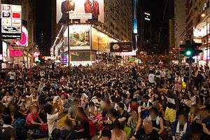
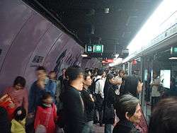
Causeway Bay or East Point is one of Hong Kong's major shopping districts. It includes the 13-storey Japanese-style department store Sogo, as well as shopping centres such as Times Square and Hysan Place. There are also smaller malls such as World Trade Centre, Windsor House, Hang Lung Centre, Fashion Island, Fashion Walk, Lee Garden One and Lee Garden Two. Causeway Bay is one of the most crowded and central areas in Hong Kong. The area contains many trendy shops carrying both locally made and imported fashion and products from around the world. As such, it is a popular social spot for young people. Many shops are open until after midnight.
Notable hotels in Causeway Bay include The Excelsior and Regal Hong Kong Hotel. Several boutique hotels have opened recently including Mira Moon Hotel on Jaffe Road.
For years, Jardine Matheson has fired a cannon shot at noon every day in Causeway Bay, by Victoria Harbour, slightly eastward of the former Kellett Island. The gunshots have served as time signals for many generations of old inhabitants of Hong Kong. This tradition still continues today. This is the "Noonday Gun" mentioned in the Noël Coward song "Mad Dogs and Englishmen".
Note that although the names of certain landmarks in the western part of Causeway Bay start with "Wan Chai" (e.g. Wan Chai Fire Station), the landmarks are across the local customary limit of Wan Chai on Canal Road.
Places in Causeway Bay
Leisure and cultural
- Hong Kong Central Library
- Noonday Gun
- Royal Hong Kong Yacht Club
- Victoria Park
Shopping
- Sogo
- Times Square
- World Trade Centre
- Hysan Place
- Windsor House
Economy
- Joy City Property Limited (formerly Hong Kong Parkview Group) - 33rd floor of the COFCO Tower (中糧大廈)[5]
- Google Hong Kong: Suite 2501, Tower 2, Times Square[6]
Transport

Main roads
- King's Road
- Causeway Road
- Gloucester Road
- Canal Road
- Hennessy Road
- Yee Wo Street
See also
- List of buildings, sites and areas in Hong Kong
References
- Straus, Karsten. "Hong Kong Beats New York For Chic Shopping ", Forbes, 21 November 2013.
- https://www.eac.hk/pdf/distco/2019dc/final/dc2019b.pdf
- https://www.ozp.tpb.gov.hk/gos/default.aspx?planno=S%2fH6%2f17&lang=0
- 銅鑼灣. 2015香港大地圖:香港篇. 萬里地圖製作中心. 2015.
- "Contact". Joy City Property. Retrieved 5 April 2019.
33/F., COFCO Tower 262 Gloucester Road Causeway Bay Hong Kong
- Traditional Chinese address: "香港銅鑼灣 告士打道262號 中糧大廈33樓" - Simplified Chinese address: "香港铜锣湾 告士打道262号 中粮大厦33楼" - "Google locations." Google. Retrieved 25 May 2016. "Google Hong Kong Suite 2501 Tower 2, Times Square 1 Matheson Street, Causeway Bay, Hong Kong"
External links
| Wikimedia Commons has media related to Causeway Bay. |