Kau Sai Chau
Kau Sai Chau is an island located in Sai Kung Peninsula, Hong Kong, with an area of 6.70 km²,[1] making it the 6th largest island of Hong Kong. It is under the administration of Sai Kung District, but not under the sub-area Sai Kung Town.
| 滘西洲 | |
|---|---|
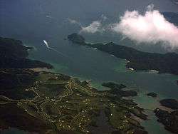 Kau Sai Chau and its golf course. Yim Tin Tsai and the breakwater are visible at the bottom right. The island at the centre right is Sharp Island. | |
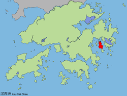 Location of Kau Sai Chau within Hong Kong | |
| Geography | |
| Location | Sai Kung |
| Area | 6.70 km2 (2.59 sq mi) |
| Highest elevation | 216 m (709 ft) |
| Administration | |
| Kau Sai Chau | |||||||||
|---|---|---|---|---|---|---|---|---|---|
| Traditional Chinese | 滘西洲 | ||||||||
| |||||||||
Geography
Kau Sai Chau is located south of the Sai Kung Peninsula. Its northern shore forms part of the southern limit of Port Shelter,[2] of which it is the largest island.[3] Kau Sai Chau is connected in the north by a breakwater to the smaller island Yim Tin Tsai. The southern tip of the island is separated by a narrow channel from Jin Island. It has a maximum elevation of 216 m.[4]
Features
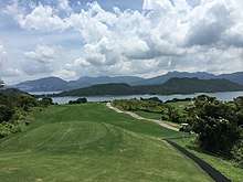
The Jockey Club Kau Sai Chau Public Golf Course, developed and run by the Hong Kong Jockey Club, is the only public golf course in Hong Kong. Opened in 1995, it occupies approximately the northern half of the island. It comprises three 18-hole golf courses: the North and South Courses were designed by Gary Player, while Nelson & Haworth designed the East Course.[5]
Kau Sai Village is a small fishing hamlet with about ten houses. It is located at the southern tip of the island.[6]
Two declared monuments of Hong Kong are located on Kau Sai Chau: a prehistoric rock carving and a Hung Shing Temple:
The prehistoric rock carving was discovered in 1976. It is located on the north-western coast of the island, in a location "where accessibility by land is extremely poor".[7]
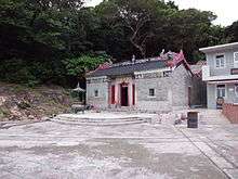
The Hung Shing Temple is located in the southern part of the island, near Kau Sai Village, of which it is the only temple.[6] The building was built before 1889.[8] It is constructed in grey bricks with a timber roof frame. The temple has been renovated four times, in 1949, in the 1970s, in 1988 and the last being from August 1999 to February 2000.[3] The restoration was declared an "Outstanding Project" by the UNESCO Asia-Pacific Heritage 2000 Awards.[9] Previously a Grade III Historic Building, the temple was declared a monument on November 15, 2002. The Hung Shing Festival (洪聖誕) is celebrated there on the 13th day of the 2nd month in Chinese calendar.[10]
There are wild boars wandering the island. They come out typically at night and cause serious damage to the golf course.[11]
Transportation
A scheduled ferry service connects Sai Kung Town and the ferry pier of the Public Golf Course.[12] Other parts of the island may be reached by privately owned boats from Sai Kung Pier.[7] The Hong Kong Jockey Club runs three Solar Sailor ferries to the island per hour.[13] Also, Kau Sai Village may be reached by an approximately 40 minute walk along the Water Services supply line (for safety reasons, walking onto the golf courses is not advised).[3]
References
- Lands Department (February 2011), Hong Kong Geographic Data (PDF), retrieved 28 August 2011
- Boundaries of Port Shelter Area
- Weatherman Extraordinaire - Hung Shing Temple, Kau Sai Chau (archive)
- Hu, Puwei; Xing, Fuwu; Chen, Lin; Wang, Meina; Wang, Faguo; Chen, Hongfeng (2011). "Vegetation and vascular plant diversity of islands surrounding Port Shelter, Hong Kong, China". Biodiversity Science. V19 (05). pp. 605–609. Archived from the original on 1 December 2015.
- Kau Sai Chau - The Jockey Club Public Golf Course Archived 2009-06-10 at the Wayback Machine
- "Heritage Hong Kong, August 2005" (PDF). Archived from the original (PDF) on 13 October 2012. Retrieved 13 July 2009.
- Antiquities and Monuments Office: Rock carving on Kau Sai Chau Archived 2009-05-05 at the Wayback Machine
- Antiquities and Monuments Office: Hung Shing Temple on Kau Sai Chau Archived 2008-09-28 at the Wayback Machine
- UNESCO Asia Pacific Heritage 2000 Awards for Culture Heritage Conservation: Hung Shing Old Temple
- Birthday of Hung Shing Kung in Kau Sai Archived 2011-10-05 at the Wayback Machine (with video)
- Parry, Hazel (28 September 2014). "Anger as hunters sent to cull wild boar damaging Sai Kung golf courses". South China Morning Post. Archived from the original on 1 December 2015. Retrieved 1 December 2015.
- Going to KSC
- Hong Kong Jockey Club Island Transport
External links
| Wikimedia Commons has media related to Kau Sai Chau. |