Grade II* listed buildings in Dacorum
There are over 20,000 Grade II* listed buildings in England. This page is a list of these buildings in the district of Dacorum in Hertfordshire.
Dacorum
| Name | Location | Type | Completed [note 1] | Date designated | Grid ref.[note 2] Geo-coordinates |
Entry number [note 3] | Image | Wikidata |
|---|---|---|---|---|---|---|---|---|
| Manor Cottage, the Old Manor House | Aldbury | House | 1516 | 14 May 1952 | SP9646812492 51°48′10″N 0°36′08″W |
1100624 | 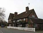 Manor Cottage, the Old Manor House | Q17542482 |
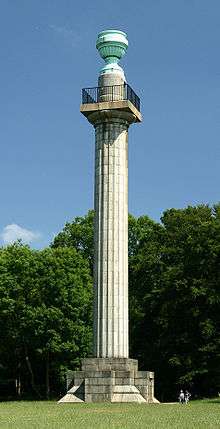
| The Bridgewater Monument | Moneybury Hill, Aldbury | Column | 1831-2 | 14 May 1952 | SP9701113118 51°48′30″N 0°35′39″W |
1078046 | Q15108035 | |
| Ash | Berkhamsted Place, Berkhamsted | House | Medieval | 9 May 1973 | SP9909108710 51°46′06″N 0°33′55″W |
1078166 |  Ash | Q17542375 |
| Ashlyns Hall | Ashlyns Hall, Berkhamsted | House | Early 19th century | 29 July 1950 | SP9915606690 51°45′01″N 0°33′54″W |
1078164 | Q17542362 | |
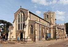
| Church of Saint Peter | Berkhamsted | Church | 13th century | 29 July 1950 | SP9935907754 51°45′35″N 0°33′42″W |
1342174 | Q5117681 | |
| Edgeworth House | Berkhamsted | House | Late 18th century | 9 May 1973 | SP9796408469 51°45′59″N 0°34′54″W |
1342141 |  | Q17542684 |
| Great Barn at Castle Hill Farm | Berkhamsted | Barn | Probably 16th century | 9 May 1973 | SP9909108780 51°46′08″N 0°33′55″W |
1078167 | | Q17542388 |
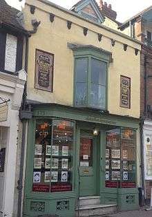
| 173 High Street | Berkhamsted | Workshop | Late 13th century | 19 May 2001 | SP9916307817 51°45′37″N 0°33′53″W |
1246942 | Q17542609 | |
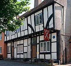
| Dean Incent's House | Berkhamsted | Timber Framed House | 16th century | 29 July 1950 | SP9932007727 51°45′34″N 0°33′45″W |
1356570 | Q15978967 | |
| Church of St Lawrence | Bovingdon | Parish Church | Medieval | 2 December 1986 | TL0171703717 51°43′23″N 0°31′44″W |
1348432 | 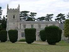 Church of St Lawrence | Q17542785 |
| Rent Street Barn | Bovingdon | Farmhouse | 16th century | 2 December 1986 | TL0213003208 51°43′06″N 0°31′23″W |
1167711 | | Q17542543 |
| Street Farm | Bovingdon | Farmhouse | 16th century | 26 January 1967 | TL0260203092 51°43′02″N 0°30′58″W |
1100478 | | Q17542470 |
| The Manor House | The Common, Chipperfield | Farmhouse | Late Medieval | 22 October 1952 | TL0477201403 51°42′06″N 0°29′07″W |
1348423 | Q17542768 | |
| Bonners | Pepperstock, Flamstead | Farmhouse | 16th century | 26 January 1967 | TL0791816702 51°50′19″N 0°26′06″W |
1296461 | | Q17542675 |
| Cheverells and attached Stables | Cheverells Green, Flamstead | Country House | c. 1700 | 26 January 1967 | TL0545115430 51°49′39″N 0°28′16″W |
1100372 | | Q17542399 |
| Gates, Gatepiers and Flanking Walls at Main Entrance to Park at Beechwood Park School | Beechwood Park, Flamstead | Gate | c. 1760 | 19 March 1987 | TL0532514322 51°49′03″N 0°28′24″W |
1348457 | | Q74824621 |
| Hill Farm | Flamstead | Farmhouse | 1740s | 19 March 1987 | TL0548314030 51°48′54″N 0°28′16″W |
1100384 | | Q17542410 |
| Saunders Almshouses | Flamstead | Almshouse | 1669 | 22 October 1952 | TL0783314611 51°49′11″N 0°26′13″W |
1348459 | Q17542827 | |
| Oak Cottage | Flaunden | House | Late 15th century | 21 June 1967 | TL0161900840 51°41′50″N 0°31′52″W |
1348450 | | Q17542816 |
| Sharlowes Farm House | Flaunden | Farmhouse | c. 1500 | 26 January 1967 | TL0155500877 51°41′51″N 0°31′55″W |
1100436 | | Q17542452 |
| Church Farmhouse and Stables | Great Gaddesden | Farmhouse | C15/C16 | 26 January 1967 | TL0282611182 51°47′23″N 0°30′38″W |
1173686 | | Q17542571 |
| Eastern Barn at Church Farm, 50m south-east of Parish Church | Great Gaddesden | Courtyard | c. 1987 | 21 February 1978 | TL0291511218 51°47′25″N 0°30′33″W |
1296091 | | Q17542662 |
| Gaddesden Hall | Water End, Great Gaddesden | Farmhouse | Late Medieval | 22 October 1952 | TL0430409597 51°46′31″N 0°29′23″W |
1101228 | Q17542505 | |
| Gaddesden Place | Bridens Camp, Great Gaddesden | Villa | 1768 | 22 October 1952 | TL0382411083 51°47′20″N 0°29′46″W |
1101253 | Q5516314 | |
| Glebe House | Great Gaddesden | House | Late 16th century | 26 January 1967 | TL0273811126 51°47′22″N 0°30′43″W |
1173673 | | Q17542557 |
| Moor Cottage | Water End, Great Gaddesden | House | Late 17th century | 26 January 1967 | TL0393510244 51°46′52″N 0°29′41″W |
1173712 | | Q17542586 |
| The Golden Parsonage and Garden Walls attached on North-east | Great Gaddesden | House | 1705 | 22 October 1952 | TL0506312536 51°48′06″N 0°28′40″W |
1101260 |  The Golden Parsonage and Garden Walls attached on North-east | Q14949356 |
| The Hoo | Great Gaddesden | House | c. 1683 | 26 January 1967 | TL0365612775 51°48′14″N 0°29′53″W |
1348057 | Q17542755 | |
| Church of All Saints | Kings Langley | Church Hall | 1976 | 26 January 1967 | TL0733502493 51°42′39″N 0°26′52″W |
1100442 | Q17542461 | |
| Langley House | Kings Langley | House | Late 16th century | 22 October 1952 | TL0719902536 51°42′41″N 0°26′59″W |
1100412 | | Q17542440 |
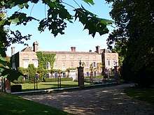
| Priory Remains (now part of the new School) and attached Buildings | Kings Langley | House | 18th century | 22 October 1952 | TL0647702700 51°42′47″N 0°27′37″W |
1348439 | .jpg) Priory Remains (now part of the new School) and attached Buildings | Q17542797 |
| Sunbury Hill Farm | Kings Langley | Farmhouse | Late 15th century | 26 January 1967 | TL0627001501 51°42′08″N 0°27′49″W |
1295908 |  Sunbury Hill Farm | Q17542651 |
| John of Gaddesden's House | Little Gaddesden | House | Late 17th century | 14 May 1952 | SP9929213401 51°48′38″N 0°33′40″W |
1100427 | | Q17871264 |
| The Manor House and No 55 | Little Gaddesden | House | 1576 | 14 May 1952 | SP9933213506 51°48′41″N 0°33′38″W |
1100390 | | Q17542426 |
| Cell Park | Markyate | Country House | 1539-40 | 22 October 1952 | TL0588217246 51°50′38″N 0°27′52″W |
1173939 | Q17542598 | |
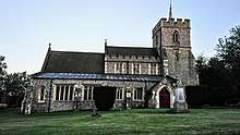
| Church of St John the Baptist | Markyate | Chapel of Ease | 1734 | 26 January 1967 | TL0588716898 51°50′26″N 0°27′52″W |
1101241 | .jpg) Church of St John the Baptist | Q17542533 |
| Amersfort, with Forecourt Walls, and linked Terraces and Loggia on South East | Potten End | House | 1911 | 19 March 1987 | TL0102908575 51°46′00″N 0°32′15″W |
1101220 | | Q17542496 |
| Church of St Lawrence | Nettleden | Chapel of Ease | c. 1470 | 30 November 1966 | TL0199910474 51°47′01″N 0°31′22″W |
1101192 | 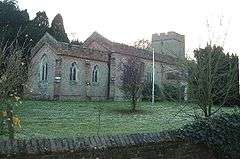 Church of St Lawrence | Q17542487 |
| 84–96 High Street | Northchurch | Timber Framed House | 15th century OR 16th century | 29 July 1950 | SP9742508774 51°46′09″N 0°35′22″W |
1295556 | 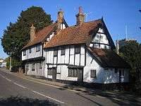 84–96 High Street | Q17542342 |
| The Clock House | Tring Park, Tring | School | 1986 | 21 September 1951 | SP9258911186 51°47′30″N 0°39′32″W |
1077999 | | Q17542242 |
| The Mansion (the Arts Educational Schools) | Tring Park, Tring | Country House | c1682-3 | 29 May 1981 | SP9267911189 51°47′30″N 0°39′27″W |
1342226 | Q2453454 | |
| Barn adjoining on North Chapel Farmhouse | Wilstone | House | Early 18th century | 23 April 1985 | SP9043513780 51°48′55″N 0°41′22″W |
1342230 | | Q17542733 |
| Tower of the Old Church of All Saints | Long Marston | Tower | 15th century | 30 November 1966 | SP8942515611 51°49′55″N 0°42′13″W |
1078012 | 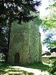 Tower of the Old Church of All Saints | Q17542258 |
| Church of St Bartholomew (Church of England) | Wigginton | Church | 1973 | 30 November 1966 | SP9404810316 51°47′01″N 0°38′17″W |
1077986 | 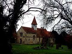 Church of St Bartholomew (Church of England) | Q17542235 |
| Charter Tower | Hemel Hempstead | Manor House | 16th century | 18 June 1948 | TL0547807715 51°45′30″N 0°28′23″W |
1262943 | 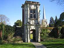 Charter Tower | Q17542632 |
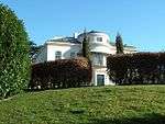
| Little Marchmont, Marchmont House | Piccotts End | Country House | Late 18th century | 18 June 1948 | TL0528808612 51°45′59″N 0°28′32″W |
1078042 | 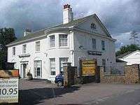 Little Marchmont, Marchmont House | Q17542267 |
| Lockers | Hemel Hempstead | Country House | 16th century | 18 June 1948 | TL0503807552 51°45′25″N 0°28′47″W |
1078118 | | Q17542331 |
| Northend Cottage | Leverstock Green | Timber Framed House | 16th century or early 17th century | 17 February 1977 | TL0846806455 51°44′47″N 0°25′49″W |
1078114 | | Q17542324 |
| Nos 6 and 8, Queensway: Wrought Iron Front Railings | Hemel Hempstead | House | Late 18th century | 18 June 1948 | TL0553707633 51°45′27″N 0°28′20″W |
1251119 | 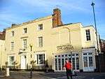 Nos 6 and 8, Queensway: Wrought Iron Front Railings | Q17542619 |
| Old Marlowes House | Hemel Hempstead | House | 18th century | 18 June 1948 | TL0554907314 51°45′16″N 0°28′20″W |
1372609 | | Q17542848 |
| Snatchup End Cottages | Hemel Hempstead | House | 1898 | 17 February 1977 | TL0611105035 51°44′02″N 0°27′53″W |
1078070 | | Q17542301 |
| The Bury | Hemel Hempstead | House | Late 18th century | 18 June 1948 | TL0544007648 51°45′27″N 0°28′25″W |
1262960 | Q17542641 | |
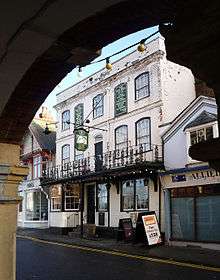
| The King's Arms Public House | Hemel Hempstead | Public House | 17th century | 18 June 1948 | TL0558007819 51°45′33″N 0°28′18″W |
1342190 | | Q17542706 |
| The Old Bell Public House | Hemel Hempstead | Inn | 1603 | 18 June 1948 | TL0557007844 51°45′34″N 0°28′18″W |
1078086 | Q17542311 | |
| Three Gables | Hemel Hempstead | House | Early 17th century | 18 June 1948 | TL0562206140 51°44′38″N 0°28′18″W |
1342168 | .jpg) Three Gables | Q17542697 |
| 80 High Street | Hemel Hempstead | House | 18th century | 20 December 1976 | TL0548407954 51°45′37″N 0°28′23″W |
1078059 | | Q17542286 |
| 109 High Street | Hemel Hempstead | House | Early 19th century | 18 June 1948 | TL0550907977 51°45′38″N 0°28′22″W |
1342194 | 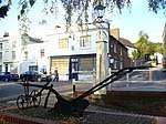 109 High Street | Q17542717 |
| Fernery, attached wall to west and steps to south, Ashridge | Little Gaddesden | Fernery | 1864 | 26 March 2019 | SP9933212031 51°47′53″N 0°33′39″W |
1462796 | 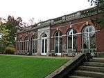 Fernery, attached wall to west and steps to south, Ashridge | Q66480081 |
.jpg)
.jpg)

.jpg)
.jpg)

.jpg)
Notes
- The date given is the date used by Historic England as significant for the initial building or that of an important part in the structure's description.
- Sometimes known as OSGB36, the grid reference is based on the British national grid reference system used by the Ordnance Survey.
- The "List Entry Number" is a unique number assigned to each listed building and scheduled monument by Historic England.
External links
![]()
This article is issued from Wikipedia. The text is licensed under Creative Commons - Attribution - Sharealike. Additional terms may apply for the media files.