Grade II* listed buildings in the City and District of St Albans
There are over 20,000 Grade II* listed buildings in England. This page is a list of these buildings in the City and District of St Albans in Hertfordshire.
St. Albans
| Name | Location | Type | Completed [note 1] | Date designated | Grid ref.[note 2] Geo-coordinates |
Entry number [note 3] | Image |
|---|---|---|---|---|---|---|---|
| Bowers House | Harpenden, St. Albans | House | Early 17th century | 26 July 1951 | TL1339014434 51°49′01″N 0°21′23″W |
1102993 |  |
| Cross Farmhouse | Harpenden, St. Albans | Farmhouse | Late 15th century or early 16th century | 26 July 1951 | TL1510512911 51°48′11″N 0°19′55″W |
1347173 | |
| Faulkners End Farmhouse | Kinsbourne Green, Harpenden, St. Albans | Farmhouse | Late 15th century | 7 February 1974 | TL1131815081 51°49′24″N 0°23′10″W |
1102973 | |
| Harpenden Hall | Harpenden, St. Albans | House | 16th century | 26 July 1951 | TL1357714139 51°48′52″N 0°21′14″W |
1103002 |  Harpenden Hall |
| Harpenden House Hotel | Harpenden, St. Albans | Town House | Late 17th century | 26 July 1951 | TL1368913978 51°48′46″N 0°21′08″W |
1347178 | 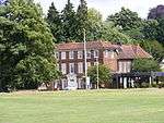 Harpenden House Hotel |
| Parish Church of St Nicholas | Harpenden, St. Albans | Parish Church | 15th century | 26 July 1951 | TL1326514427 51°49′01″N 0°21′30″W |
1347212 | |
| Hammonds End House | Harpenden Rural, St. Albans | Country House | c1700-1710 | 11 August 1955 | TL1237412241 51°47′51″N 0°22′19″W |
1295656 | |
| Harpendenbury Farmhouse | Harpenden Rural, St. Albans | Farmhouse | 15th century or early 16th century | 27 September 1984 | TL1084013994 51°48′49″N 0°23′37″W |
1174608 | |
| All Saints Pastoral Centre, including Chapel | London Colney, St. Albans | Chapel | 1927-1964 | 23 June 1972 | TL1750002827 51°42′43″N 0°18′03″W |
1295615 | 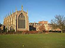 All Saints Pastoral Centre, including Chapel |
| Cumberland House, including Front Wall and Railings | Redbourn Common, Redbourn, St. Albans | House | 1974 | 19 October 1953 | TL1063312266 51°47′53″N 0°23′49″W |
1102901 | 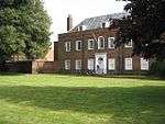 Cumberland House, including Front Wall and Railings |
| Redbournbury | Redbourn, St. Albans | Farmhouse | 15th century | 27 September 1984 | TL1202810736 51°47′03″N 0°22′38″W |
1347213 | |
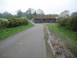
| Redbournbury Mill, including Front Railings | Redbourn, St. Albans | Mill House | Mid 18th century | 27 September 1984 | TL1185510775 51°47′04″N 0°22′47″W |
1175121 | 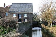 Redbournbury Mill, including Front Railings |
| The Priory | Redbourn, St. Albans | Town House | c1710-20 | 19 October 1953 | TL1078312237 51°47′52″N 0°23′42″W |
1295534 | .jpg) The Priory |
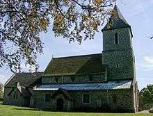
| Church of St Leonard | Sandridge, St. Albans | Parish Church | Late 11th century | 19 October 1953 | TL1712410554 51°46′53″N 0°18′13″W |
1308298 | |
| Gorhambury (New Gorhambury House) | St Michael, St. Albans | Country House | 1777-84 | 19 October 1953 | TL1137407850 51°45′30″N 0°23′16″W |
1102915 | 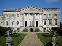 Gorhambury (New Gorhambury House) |
| Temple Cottage (300 Metres South of Old Gorhambury) | St. Michael, St. Albans | House | Late 19th century | 27 September 1984 | TL1106707320 51°45′13″N 0°23′32″W |
1102918 |  Temple Cottage (300 Metres South of Old Gorhambury) |
| Westwick Cottage | St. Michael, St. Albans | House | 16th century | 19 October 1953 | TL0915706631 51°44′52″N 0°25′13″W |
1102898 | |
| Burstone Manor House | How Wood, St. Stephen, St. Albans | House | 12th century | 19 October 1953 | TL1353403713 51°43′14″N 0°21′28″W |
1102862 | |
| Bride Hall | Wheathampstead, St. Albans | Manor House | Late 16th century | 19 October 1953 | TL1905115943 51°49′46″N 0°16′26″W |
1347258 | |
| Hyde Mill Granary and Store (that part in Wheathampstead) | Wheathampstead, St. Albans | Corn Mill | Late 19th century | 22 June 1998 | TL1323216990 51°50′24″N 0°21′28″W |
1119789 |  Hyde Mill Granary and Store (that part in Wheathampstead) |
| Waterend House | Waterend, Wheathampstead, St. Albans | House | Mid 17th century | 19 October 1953 | TL2039313849 51°48′37″N 0°15′18″W |
1103637 | 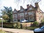 Waterend House |
| Abbey Gate House | St. Albans | Villa | Early 19th century | 27 August 1971 | TL1434807069 51°45′02″N 0°20′42″W |
1347098 | 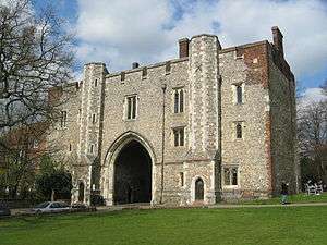 Abbey Gate House |
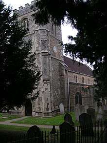
| Church of St Peter | St. Albans | Parish Hall | 1992 | 8 May 1950 | TL1500607631 51°45′20″N 0°20′07″W |
1103057 | 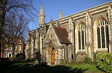 Church of St Peter |
| Church of St Stephen | St. Albans | Parish Hall | 1989-1991 | 8 May 1950 | TL1413606074 51°44′30″N 0°20′54″W |
1295653 | .JPG) Church of St Stephen |
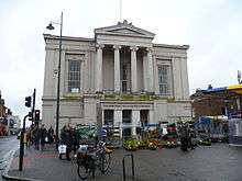
| Court House (Town Hall) | St. Albans | Court House | 1826 | 8 May 1950 | TL1475207246 51°45′08″N 0°20′20″W |
1296135 | |
| Darrowfield House | St. Albans | House | 1950 | 8 May 1950 | TL1367607331 51°45′11″N 0°21′16″W |
1103086 | .jpg) Darrowfield House |
| Holywell House | St. Albans | House | 1785 | 8 May 1950 | TL1463906964 51°44′59″N 0°20′27″W |
1103099 | |
| Kingsbury Barn | St. Albans | Grange Barn | 1390s | 27 August 1971 | TL1386007557 51°45′19″N 0°21′07″W |
1347102 | |
| Manor Garden House | St. Albans | House | 17th century | 8 May 1950 | TL1395007426 51°45′14″N 0°21′02″W |
1103113 | |
| Romeland House | St. Albans | House | Mid 18th century | 8 May 1950 | TL1439007217 51°45′07″N 0°20′39″W |
1103080 | .jpg) Romeland House |
| St Michael's Manor House | St. Albans | Manor House | Late 17th century | 8 May 1950 | TL1402007364 51°45′12″N 0°20′58″W |
1347093 | |
| The Crown and Anchor | St. Albans | Shop | 15th century | 27 August 1971 | TL1464606892 51°44′56″N 0°20′26″W |
1103095 | |
| The Grange | St. Albans | House | Late 18th century | 8 May 1950 | TL1487007357 51°45′11″N 0°20′14″W |
1174089 | |
| The Tudor Tavern | St. Albans | Public House | Modern | 8 May 1950 | TL1457807164 51°45′05″N 0°20′30″W |
1347120 | 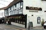 The Tudor Tavern |
| The White Hart | St. Albans | Inn | 17th century | 8 May 1950 | TL1468006991 51°45′00″N 0°20′25″W |
1347142 | 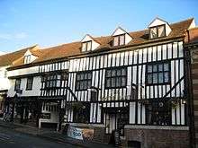 The White Hart |
| 13 Fishpool Street | St. Albans | House | late C16-early 17th century | 8 May 1950 | TL1427407162 51°45′05″N 0°20′45″W |
1103153 | |
| 2 Sopwell Lane | St. Albans | Lodging House | 16th century | 27 August 1971 | TL1466706887 51°44′56″N 0°20′25″W |
1347166 | |
| 107 St Peter's Street | St. Albans | House | Early 18th century | 8 May 1950 | TL1496207654 51°45′21″N 0°20′09″W |
1103049 | |
Notes
- The date given is the date used by Historic England as significant for the initial building or that of an important part in the structure's description.
- Sometimes known as OSGB36, the grid reference is based on the British national grid reference system used by the Ordnance Survey.
- The "List Entry Number" is a unique number assigned to each listed building and scheduled monument by Historic England.
External links
![]()
This article is issued from Wikipedia. The text is licensed under Creative Commons - Attribution - Sharealike. Additional terms may apply for the media files.