Grade II* listed buildings in East Hertfordshire
There are over 20,000 Grade II* listed buildings in England. This page is a list of these buildings in the district of East Hertfordshire in Hertfordshire.
List
| Name | Location | Type | Completed [note 1] | Date designated | Grid ref.[note 2] Geo-coordinates |
Entry number [note 3] | Image |
|---|---|---|---|---|---|---|---|
| Church of St Mary | Church End, Albury, East Hertfordshire | Parish Church | 13th century | 22 February 1967 | TL4355924734 51°54′10″N 0°05′07″E |
1308146 | 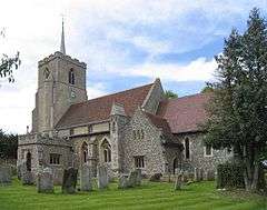 Church of St Mary |
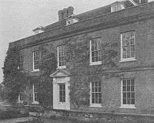
| Ardeley Bury (700m to west of Church) | Ardeley | Country House | Late 17th century | 19 October 1951 | TL3012127125 51°55′39″N 0°06′33″W |
1101447 |  |
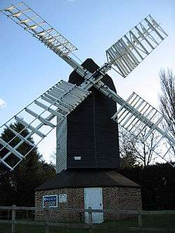
| Cromer Windmill | Cromer, Ardeley | Windmill | c. 1222 | 22 February 1967 | TL3045228642 51°56′28″N 0°06′13″W |
1101453 | |
| Farmhouse at Chapel Farm including Former Congregational Chapel | Wood End, Ardeley | Farmhouse | Late 16th century | 31 May 1984 | TL3256325473 51°54′43″N 0°04′27″W |
1101421 | 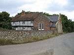 Farmhouse at Chapel Farm including Former Congregational Chapel |
| Farmhouse at Cromer Farm | Cromer, Ardeley | Farmhouse | Late 16th century or early 17th century | 19 October 1951 | TL2970228225 51°56′15″N 0°06′53″W |
1101451 | |
| Parish Church of St Mary the Virgin | Aston | Parish Church | c. 1230 | 24 November 1966 | TL2716722614 51°53′15″N 0°09′13″W |
1101433 | 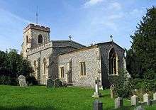 Parish Church of St Mary the Virgin |
| Waterbridge | Frogmore Hill, Aston | House | c. 1910 | 24 November 1966 | TL2857121412 51°52′35″N 0°08′01″W |
1347945 | |
| 43 and 45 Benington Road | Aston | Timber Framed House | Mid-late 16th century | 31 May 1984 | TL2754022722 51°53′18″N 0°08′53″W |
1175062 | |
| Bayford House | Bayford | House | Early 17th century | 24 November 1966 | TL3060707990 51°45′19″N 0°06′33″W |
1101707 | |
| Bayfordbury | Bayford | Country House | 1759-62 | 20 October 1952 | TL3153610448 51°46′38″N 0°05′41″W |
1176752 | |
| Church of St Mary | Bayford | Church | Medieval | 24 November 1966 | TL3097408840 51°45′47″N 0°06′13″W |
1101712 | Jan2006.jpg) Church of St Mary |
| Benington Bury and Peterscourt | Benington | House | Sold 1914 | 20 October 1952 | TL2973423913 51°53′55″N 0°06′57″W |
1101374 | |
| Benington Lordship | Benington | Country House | Late 17th century | 24 November 1966 | TL2965923660 51°53′47″N 0°07′01″W |
1101404 |  Benington Lordship |
| The Bell Public House | Benington | Cross Passage House | late medieval | 20 October 1952 | TL2992723569 51°53′44″N 0°06′47″W |
1101413 | .jpg) The Bell Public House |
| Black Lion Inn | Bishop's Stortford | House | Early 17th century | 18 October 1949 | TL4877621391 51°52′17″N 0°09′35″E |
1101601 |  Black Lion Inn |
| Boar's Head Inn | Bishop's Stortford | House | Late 16th century | 18 October 1949 | TL4859821372 51°52′16″N 0°09′25″E |
1176189 | |
| 10, High St (formerly Tissimans) | Bishop's Stortford | House | Early 19th century | 18 October 1949 | TL4865821400 51°52′17″N 0°09′28″E |
1101615 | .jpg) 10, High St (formerly Tissimans) |
| 8, High St (formerly Tissimans) | Bishop's Stortford | House | 16th century | 18 October 1949 | TL4866621401 51°52′17″N 0°09′29″E |
1101614 | 8, High St (formerly Tissimans) |
| Bramfieldbury | Bramfield | House | 17th century | 24 November 1966 | TL2851215397 51°49′21″N 0°08′12″W |
1089159 |  Bramfieldbury |
| Braughing Bury | Green End, Braughing | House | Early 17th century | 22 February 1967 | TL3951925348 51°54′33″N 0°01′37″E |
1347540 | |
| The Brown Bear Public House | Braughing | House | 17th century | 22 February 1967 | TL3975225133 51°54′26″N 0°01′48″E |
1296288 | .jpg) The Brown Bear Public House |
| The Old Rose and Crown | Braughing | Pub/House | c. 1600 | 22 February 1967 | TL3958425218 51°54′29″N 0°01′40″E |
1102331 | .jpg) The Old Rose and Crown |
| Upp Hall | The Warren, Braughing | Country House | late 16th century or 17th century | 19 October 1951 | TL4072923954 51°53′47″N 0°02′38″E |
1102282 | |
| Barn at Upp Hall (40m north-west of Mansion) | The Warren, Braughing | Barn | 19th century | 22 February 1967 | TL4090824194 51°53′55″N 0°02′48″E |
1347531 | |
| Beeches Farmhouse | Brent Pelham | Farmhouse | 18th century and 19th century | 19 October 1951 | TL4459530431 51°57′13″N 0°06′10″E |
1307905 |  Beeches Farmhouse |
| Buckland House | Buckland | House | Early 18th century | 22 February 1967 | TL3563233818 51°59′11″N 0°01′35″W |
1176027 | |
| Church of St Andrew (Redundant Churches Fund) | Buckland | Parish Church | 14th century | 22 February 1967 | TL3584433857 51°59′12″N 0°01′23″W |
1347742 | 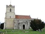 Church of St Andrew (Redundant Churches Fund) |
| Former Church of St Bartholomew | Buntingford | Parish Church (ruined) | Early 13th century | 22 February 1967 | TL3693830112 51°57′10″N 0°00′32″W |
1101329 |  Former Church of St Bartholomew |
| The Almhouses | Buntingford | Almshouse | 1684 | 19 October 1951 | TL3627329338 51°56′45″N 0°01′07″W |
1101350 | |
| Victoria House | Buntingford | Jettied House | 15th century | 19 October 1951 | TL3623129474 51°56′50″N 0°01′09″W |
1101310 | |
| Broadfield Hall Stables | Broadfield, Cottered | Stable | c. 1619 | 6 July 1984 | TL3244931005 51°57′42″N 0°04′25″W |
1101292 | |
| Holy Trinity Church | Throcking, Cottered | Parish Church | 13th century | 22 February 1967 | TL3383630165 51°57′14″N 0°03′14″W |
1175183 | .jpg) Holy Trinity Church |
| Parish Church of St John the Baptist | Cottered | Parish Church | Mid 14th century | 22 February 1967 | TL3174629215 51°56′45″N 0°05′05″W |
1101295 |  Parish Church of St John the Baptist |
| Rumbolds | Flanders Green, Cottered | Jettied House | Early 16th century | 22 February 1967 | TL3254828501 51°56′21″N 0°04′24″W |
1175297 | |
| Church of All Saints | Datchworth | Church | late 12th century or early 13th century | 24 November 1966 | TL2677419263 51°51′27″N 0°09′38″W |
1341457 |  Church of All Saints |
| Staples Cottage | Datchworth | Farmhouse | later 19th century | 24 November 1966 | TL2759919619 51°51′38″N 0°08′54″W |
1175159 | |
| Church of St Botolph | Eastwick | Parish Church | 13th century | 24 January 1967 | TL4340611651 51°47′07″N 0°04′39″E |
1101264 | 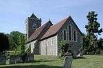 Church of St Botolph |
| Church of St Mary | Furneux Pelham | Parish Church | Mid 13th century | 22 February 1967 | TL4316827953 51°55′54″N 0°04′51″E |
1307889 | 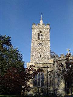 Church of St Mary |
| Furneux Pelham Hall | Furneux Pelham | Manor House | Late 16th century | 19 October 1951 | TL4284328014 51°55′56″N 0°04′34″E |
1176538 | .jpg) Furneux Pelham Hall |
| Gilston Park, 400m along Drive west-south-west from Cumberland Lodge | Gilston | Country House | 1852 | 24 January 1967 | TL4410712906 51°47′46″N 0°05′18″E |
1175745 | 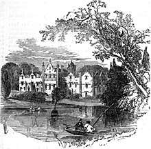 Gilston Park, 400m along Drive west-south-west from Cumberland Lodge |
| Parish Church of St John the Baptist | Great Amwell | Parish Church | 11th century | 24 January 1967 | TL3718212508 51°47′40″N 0°00′44″W |
1341839 | 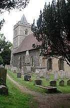 Parish Church of St John the Baptist |
| Aisled Barn at Mundenbury (70m to south-east of House) | Great Munden | Barn | 17th century | 24 January 1984 | TL3561024202 51°54′00″N 0°01′49″W |
1173699 | |
| Farmhouse at High Trees Farm (along Track 200m from Lane) | Great Munden | Cross Passage House | Medieval | 4 December 1951 | TL3547621945 51°52′47″N 0°02′00″W |
1296238 | |
| Mundenbury (60m to north-north-east of St Nicholas's Church) | Great Munden, Great Munden | House | c. 1700 | 24 January 1967 | TL3555124242 51°54′01″N 0°01′52″W |
1347555 | |
| North Range of Farm Buildings at Peasfield (35m east-north-east of House) | Cherry Green, Great Munden | Farm Building | 15th, 16th and 17th century | 24 January 1984 | TL3507925833 51°54′53″N 0°02′15″W |
1102285 | |
| Parish Church of St Nicholas | Great Munden | Parish Church | Early 12th century | 24 January 1967 | TL3551924185 51°53′59″N 0°01′54″W |
1173651 | 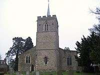 Parish Church of St Nicholas |
| Amores including Outbuildings | Hertingfordbury, Hertford | House | Early to Mid 16th century | 10 February 1950 | TL3073611972 51°47′28″N 0°06′21″W |
1268719 | .jpg) Amores including Outbuildings |
| Bailey Hall | Hertford | House | c. 1700 | 10 February 1950 | TL3268412468 51°47′42″N 0°04′39″W |
1268782 | |
| Bailey Walls, north-east range to Hertford Castle | Hertford Castle, Hertford | Castle | 1171-1174 | 10 February 1950 | TL3253112552 51°47′45″N 0°04′47″W |
1268984 | |
| Bailey Walls, south-east range to Hertford Castle | Hertford Castle, Hertford | Castle | 1171-1174 | 10 February 1950 | TL3248412433 51°47′42″N 0°04′49″W |
1268985 |  Bailey Walls, south-east range to Hertford Castle |
| Beadle House | Bull Plain, Hertford | House | 1702-1704 | 10 February 1950 | TL3264712687 51°47′50″N 0°04′40″W |
1268974 | .jpg) Beadle House |
| Bengeo Hall | Bengeo, Hertford | House | Early 18th century | 10 February 1950 | TL3300313792 51°48′25″N 0°04′20″W |
1268712 | |
| Bengeo Hall Stables | Bengeo, Hertford | Stables | Early to Mid 18th century | 12 April 1973 | TL3295213828 51°48′26″N 0°04′23″W |
1268715 | |
| Bridgeman House | Hertford | House | 18th century | 10 February 1950 | TL3229912268 51°47′36″N 0°04′59″W |
1268681 | |
| Cecil House | Hertford | House | Earlier | 10 February 1950 | TL3228712587 51°47′47″N 0°04′59″W |
1268744 | .jpg) Cecil House |
| Church of All Saints with St John | Hertford | Church | 15th century and earlier | 12 April 1973 | TL3279912457 51°47′42″N 0°04′33″W |
1268783 | |
| Church of St Mary and St John | Hertingfordbury, Hertford | Parish Church | 13th century | 10 February 1950 | TL3085411948 51°47′27″N 0°06′15″W |
1268722 | 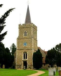 Church of St Mary and St John |
| County Hall including Terraces and Fountain | Hertford | County hall | 1935-1939 | 9 September 1996 | TL3238111943 51°47′26″N 0°04′55″W |
1268807 | 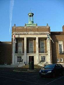 County Hall including Terraces and Fountain |
| Friends Meeting House | Hertford | Friends Meeting House | 1670 | 10 February 1950 | TL3281212705 51°47′50″N 0°04′32″W |
1268759 | 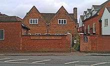 Friends Meeting House |
| Goldings including Retaining Walls and Steps to Forecourt and Terrace | Goldings, Hertford | Country House | 1650-1660 | 8 April 1968 | TL3102914252 51°48′42″N 0°06′03″W |
1268815 |  Goldings including Retaining Walls and Steps to Forecourt and Terrace |
| Lombard House | Hertford | House | Early 17th century | 10 February 1950 | TL3260712741 51°47′51″N 0°04′42″W |
1268978 |  Lombard House |
| Morgans Junior School | Hertford | Elementary School | 1948-1949 | 6 May 1998 | TL3255211668 51°47′17″N 0°04′47″W |
1119734 | |
| North Road House | Hertford | Villa | 1827-1828 | 10 February 1950 | TL3217912612 51°47′48″N 0°05′05″W |
1268839 | |
| No 43 St Andrew St including St Nicholas Hall | Hertford | Apartment | 1950 | 10 February 1950 | TL3234012603 51°47′47″N 0°04′56″W |
1268740 | |
| Old Cross Wharf | Hertford | Malt House | 16th century | 9 September 1996 | TL3253412724 51°47′51″N 0°04′46″W |
1268795 |  Old Cross Wharf |
| The Old Vicarage | Hertford | House | 17th century | 12 April 1973 | TL3269412501 51°47′44″N 0°04′38″W |
1268954 | |
| The Red House | Hertford | House | 17th century | 10 February 1950 | TL3289612698 51°47′50″N 0°04′27″W |
1268915 | |
| The Salisbury Arms | Hertford | Timber Framed House | Early 15th century | 10 February 1950 | TL3267412558 51°47′45″N 0°04′39″W |
1268933 | 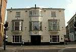 The Salisbury Arms |
| The Walnuts (No 23, Castle St) including Front Railings | Hertford | House | 17th century | 10 February 1950 | TL3257812412 51°47′41″N 0°04′44″W |
1268945 |  The Walnuts (No 23, Castle St) including Front Railings |
| Warren Park, Warrenfield | Bengeo, Hertford | House | 1970 | 10 February 1950 | TL3236913342 51°48′11″N 0°04′54″W |
1269002 | |
| Yeomanry House and attached Front Area Railings | Hertford | House | c. 1725 | 12 April 1973 | TL3236312648 51°47′49″N 0°04′55″W |
1268733 | |
| 3–11 Fore Street | Hertford | Apartment | 1950 | 10 February 1950 | TL3264312569 51°47′46″N 0°04′41″W |
1268928 | |
| 42 Fore Street | Hertford | Apartment | c. 1825 | 10 February 1950 | TL3270512572 51°47′46″N 0°04′37″W |
1268937 | 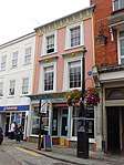 42 Fore Street |
| 130 Fore Street | Hertford | House | Early 19th century | 10 February 1950 | TL3286012643 51°47′48″N 0°04′29″W |
1268918 |  130 Fore Street |
| 2 St Andrew Street | Hertford | House | Early to Mid 18th century | 10 February 1950 | TL3243912673 51°47′49″N 0°04′51″W |
1268763 | |
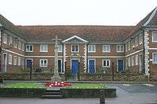
| Main Quadrangle and Memorial Hall attached, at Haileybury and Imperial Service College | Hertford Heath | Teachers House | 1806 | 24 January 1967 | TL3580810787 51°46′45″N 0°01′58″W |
1084375 |  Main Quadrangle and Memorial Hall attached, at Haileybury and Imperial Service College |
| Woolmer's Park with attached Outbuildings and Wall | Letty Green, Hertingfordbury | Country House | 18th century | 20 October 1952 | TL2856510243 51°46′34″N 0°08′17″W |
1089105 | |
| East Barn at Shingle Hall with Wall attached at south-west, 20m north-east of House | Trims Green, High Wych | Wall | Late 16th century | 30 April 1985 | TL4694317239 51°50′04″N 0°07′52″E |
1220519 | |
| Farmhouse at Blounts Farm | Allen's Green, High Wych | Farmhouse | 15th century or early 16th century | 22 February 1967 | TL4572317946 51°50′28″N 0°06′50″E |
1220692 | |
| Great Barn at Bursteads 35m north-east of House | Trims Green, High Wych | Aisled Barn | 16th century | 30 April 1985 | TL4767217256 51°50′04″N 0°08′31″E |
1290870 | |
| North Barn at Shingle Hall 60m north-north-west of House | Trims Green, High Wych | Aisled Barn | 14th century or early 15th century | 30 April 1985 | TL4688717283 51°50′05″N 0°07′50″E |
1220616 | |
| Parish Church of St James the Great | High Wych | Parish Church | 1860-61 | 22 February 1967 | TL4635214131 51°48′24″N 0°07′17″E |
1220513 | 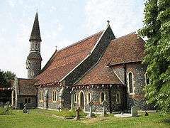 Parish Church of St James the Great |
| Church of St Nicholas | Great Hormead, Hormead | Parish Church | 13th century or earlier | 22 February 1967 | TL3999229566 51°56′49″N 0°02′08″E |
1101835 | 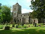 Church of St Nicholas |
| Great Hormead Dane | Great Hormead, Hormead | Cross Passage House | Late 16th century | 22 February 1967 | TL4041630141 51°57′07″N 0°02′31″E |
1176619 | |
| Hare Street House | Hare Street, Hormead | Timber Framed House | 16th century | 19 October 1951 | TL3903729830 51°56′59″N 0°01′18″E |
1176454 | |
| Oak Cottage | Hare Street, Hormead | Cross Wing House | 15th century | 22 February 1967 | TL3902929422 51°56′45″N 0°01′17″E |
1101855 | 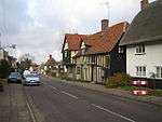 Oak Cottage |
| The Brick House | Great Hormead, Hormead | Tower House | c. 1570 | 19 October 1951 | TL4125831050 51°57′36″N 0°03′16″E |
1307967 | |
| The Old Rectory | Great Hormead, Hormead | Cross Wing House | c. 1500 | 22 February 1967 | TL4033330111 51°57′06″N 0°02′26″E |
1101825 | |
| Old House | Hunsdon | House | Late Medieval | 4 December 1951 | TL4181414435 51°48′38″N 0°03′21″E |
1307772 | |
| Olives Farm House along Track 220m from Road | Hunsdon | House | Later 17th century | 4 December 1951 | TL4080712652 51°47′41″N 0°02′25″E |
1101951 | |
| Tanners | Hunsdon | Farmhouse | Later 19th century | 24 January 1967 | TL4163314054 51°48′26″N 0°03′11″E |
1347692 | |
| The Big Black Barn at Hunsdon Lodge Farm 500m along Track | Hunsdon | Barn | 18th century | 14 April 1983 | TL4243614364 51°48′35″N 0°03′53″E |
1101968 | .jpg) The Big Black Barn at Hunsdon Lodge Farm 500m along Track |
| The Pump House | Hunsdon | House | 17th century | 24 January 1967 | TL4181814172 51°48′30″N 0°03′20″E |
1176452 | |
| Little Berkhamsted House | Little Berkhamsted | House | 1732 | 20 October 1952 | TL2926707988 51°45′20″N 0°07′43″W |
1341452 | |
| Stratton's Tower | Little Berkhamsted | House | 1986 | 24 November 1966 | TL2949508107 51°45′24″N 0°07′31″W |
1341449 | 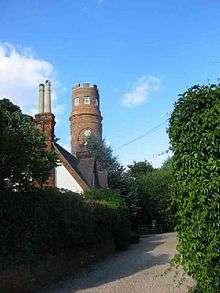 Stratton's Tower |
| Ashmeads | Hadham Ford, Little Hadham | House | c. 1600 | 22 February 1967 | TL4355221678 51°52′31″N 0°05′02″E |
1210460 | |
| Clintons | Bury Green, Little Hadham | House | 16th century | 19 October 1951 | TL4497420984 51°52′07″N 0°06′15″E |
1290634 | |
| Fiddlers Croft 250m along Drive beside Stonehouse Farm | Little Hadham | House | c. 1603 | 22 February 1967 | TL4446322412 51°52′54″N 0°05′51″E |
1290063 |  Fiddlers Croft 250m along Drive beside Stonehouse Farm |
| Gatehouse Range at Hadham Hall 60m west of Hall | Little Hadham | Privy House | Early 16th century | 22 February 1967 | TL4517822766 51°53′04″N 0°06′29″E |
1211100 | |
| Hadham Hall (Hadham Hall School) | Little Hadham | House | 15th century | 19 October 1957 | TL4524922765 51°53′04″N 0°06′32″E |
1211099 | |
| Lodge Farmhouse 140m from Road | Hadham Ford, Little Hadham | House | Mid 19th century | 30 April 1985 | TL4300022162 51°52′47″N 0°04′34″E |
1290605 | |
| Lower Farmhouse | Bury Green, Little Hadham | House | 17th century | 19 October 1951 | TL4521020981 51°52′07″N 0°06′28″E |
1290740 | |
| May Cottage and Gouldburn | Hadham Ford, Little Hadham | House | 16th century | 30 April 1985 | TL4358421699 51°52′31″N 0°05′04″E |
1210437 | |
| The Old Brick House and No. 2 Ford Hill | Hadham Ford, Little Hadham | House | 17th century | 22 February 1967 | TL4354821597 51°52′28″N 0°05′02″E |
1210461 | |
| The Whare | Little Hadham | Hall House | 17th century | 22 February 1967 | TL4402222747 51°53′05″N 0°05′28″E |
1220772 | |
| Westfield | Westland Green, Little Hadham | House | Mid 17th century | 30 April 1985 | TL4236521512 51°52′26″N 0°04′00″E |
1211024 | |
| Burnside Cottage & Hunts Cottage | Dane End, Little Munden | House | 17th century | 24 January 1967 | TL3324421329 51°52′29″N 0°03′57″W |
1102267 | |
| Church of St Mary | Meesdenbury, Meesden | Parish Church | Early 12th century | 22 February 1967 | TL4389532557 51°58′22″N 0°05′36″E |
1347765 | 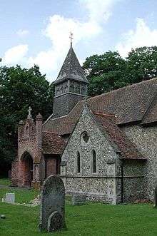 Church of St Mary |
| Bishops Folly, the Palace, the Palace East & the Palace West | Much Hadham | Bishops Palace | Until 1647 | 19 October 1951 | TL4307019722 51°51′28″N 0°04′34″E |
1213683 | |
| Camwell Hall Farmhouse | Much Hadham | Farmhouse | Late 16th century | 22 February 1967 | TL4174617613 51°50′21″N 0°03′22″E |
1211348 | |
| Farmhouse at Yewtree Farm | Hadham Cross, Much Hadham | Continuous Jetty House | c. 1600 | 19 October 1951 | TL4263718524 51°50′50″N 0°04′10″E |
1213270 | |
| Hoglands | Perry Green, Much Hadham | House | 17th century | 22 February 1967 | TL4384317429 51°50′13″N 0°05′11″E |
1213427 | 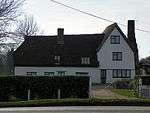 Hoglands |
| Stable Block and adjoining Cottages at Moor Place | Kettle Green, Much Hadham | House | Early-mid 18th century | 22 February 1967 | TL4221818825 51°51′00″N 0°03′48″E |
1289133 | |
| Stable Block at Much Hadham Hall | Much Hadham | Stable | c1726-9 | 22 February 1967 | TL4282019333 51°51′16″N 0°04′20″E |
1212818 | |
| Stable Block at the Lordship | Much Hadham | Stable | Early 18th century | 22 February 1967 | TL4284419893 51°51′34″N 0°04′22″E |
1212469 | |
| The Forge, Forge Cottage and Horseshoe Cottage | Much Hadham | House | c. 1600 | 22 February 1967 | TL4276219257 51°51′13″N 0°04′17″E |
1289340 | |
| The Lordship | Much Hadham | House | 16th century and early 17th century | 22 February 1967 | TL4289019866 51°51′33″N 0°04′25″E |
1289499 | .jpg) The Lordship |
| The Old House | Much Hadham | House | 1826 | 22 February 1967 | TL4283219516 51°51′21″N 0°04′21″E |
1365721 | 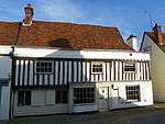 The Old House |
| The Red House | Much Hadham | House | c. 1720 | 22 February 1967 | TL4278419369 51°51′17″N 0°04′18″E |
1289286 | 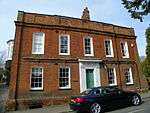 The Red House |
| The White House | Much Hadham | House | 17th century | 22 February 1967 | TL4277419291 51°51′14″N 0°04′18″E |
1212950 |  The White House |
| Church of St Catherine | Sacombe Green, Sacombe | Parish Church | 14th century | 24 November 1966 | TL3360219360 51°51′25″N 0°03′41″W |
1045912 | 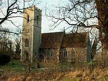 Church of St Catherine |
| Sacombe House with attached Service Blocks and Wall to East | Sacombe | Apartment | 1966 | 24 November 1966 | TL3392618977 51°51′12″N 0°03′25″W |
1341455 | |
| Aisled Barn 12m east of House at Redericks Farm | Sawbridgeworth | Aisled Barn | C15/C16 | 2 October 1981 | TL4633012827 51°47′42″N 0°07′14″E |
1101617 | |
| Falconers | Sawbridgeworth | House | ?C17 | 2 October 1981 | TL4747414180 51°48′25″N 0°08′16″E |
1101677 | |
| Great Hyde Hall | Great Hyde Hall, Sawbridgeworth | Apartment | 1978 | 6 October 1971 | TL4958715397 51°49′02″N 0°10′08″E |
1347838 | |
| Lodges at South Entrance to Park of Great Hyde Hall | Great Hyde Hall, Sawbridgeworth | Gate Lodge | c. 1806 | 6 October 1971 | TL4923715084 51°48′52″N 0°09′49″E |
1176335 | 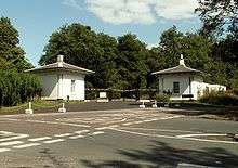 Lodges at South Entrance to Park of Great Hyde Hall |
| Pishiobury Park Mansion and attached Offices and Garden Walls and Norman Gateway | Pishiobury Park, Sawbridgeworth | Country House | 1580-90 | 6 June 1952 | TL4808213412 51°47′59″N 0°08′46″E |
1307762 |  Pishiobury Park Mansion and attached Offices and Garden Walls and Norman Gateway |
| Stable Block on South of Upper Courtyard at Pishiobury Park | Pishiobury Park, Sawbridgeworth | Gate | 18th century | 6 June 1952 | TL4803513379 51°47′58″N 0°08′44″E |
1176781 | |
| The Market House | Sawbridgeworth | Cross Passage House | 16th century | 6 June 1952 | TL4837614834 51°48′45″N 0°09′04″E |
1101644 |  The Market House |
| The Red House | Sawbridgeworth | House | c. 1700 | 6 June 1952 | TL4820714883 51°48′47″N 0°08′55″E |
1101683 | |
| 19 Knight Street | Sawbridgeworth | House | 20 years after 1800-10 | 2 October 1981 | TL4843014996 51°48′50″N 0°09′07″E |
1101680 | |
| 40 Knight Street | Sawbridgeworth | House | c. 1720 | 6 June 1952 | TL4838014856 51°48′46″N 0°09′04″E |
1101643 | |
| Barn and Stables adjacent at Plashes Farm (40m north-east of House) | Colliers End, Standon | Timber Framed House | 16th century | 4 October 1983 | TL3799620363 51°51′53″N 0°00′10″E |
1308109 | |
| Chapel at St Edmund's College (RC) (at North End of Main Building) | Old Hall Green, Standon | Chapel | 1845-1853 | 24 January 1967 | TL3718022128 51°52′51″N 0°00′30″W |
1308305 | |
| Crown and Falcon Public House | Puckeridge, Standon | Inn | 16th century | 24 January 1967 | TL3863323287 51°53′27″N 0°00′47″E |
1176373 | 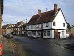 Crown and Falcon Public House |
| Farmhouse at Great Barwick Farm | Standon | Farmhouse | Mid 16th century | 24 January 1967 | TL3854318865 51°51′04″N 0°00′36″E |
1102382 | |
| Knights Court | Standon | House | 16th century or earlier | 24 January 1967 | TL3962822190 51°52′51″N 0°01′38″E |
1347492 | |
| Standon Lordship West, and Standon Lordship East (on West Back of River Rib 1 Km south of Standon Village) | Standon | Country House | c. 1872 | 4 December 1951 | TL3925721444 51°52′27″N 0°01′17″E |
1347501 | 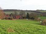 Standon Lordship West, and Standon Lordship East (on West Back of River Rib 1 Km south of Standon Village) |
| West Barn at Great Barwick Farm (50m west of House) | Standon | Barn | 14th century or earlier | 23 November 1983 | TL3849218880 51°51′05″N 0°00′34″E |
1102383 | |
| 59 High Street | Standon | House | c. 1700 | 24 January 1967 | TL3965222288 51°52′54″N 0°01′39″E |
1176629 | .jpg) 59 High Street |
| 54, 56, 58 and 60 High Street | Puckeridge, Standon | Timber Framed House | 16th century or earlier | 24 January 1967 | TL3858523229 51°53′25″N 0°00′45″E |
1347522 | |
| 59 and 61 Cambridge Road | Colliers End, Standon | House | Early 16th century | 24 January 1967 | TL3713920746 51°52′06″N 0°00′34″W |
1308335 | |
| All Nations Christian College (Easneye Mansion) | Stanstead Abbots | Country House | 1867-8 | 30 September 1983 | TL3806113430 51°48′09″N 0°00′03″E |
1078763 | 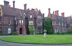 All Nations Christian College (Easneye Mansion) |
| Parish Church of St Andrew | Stanstead Abbotts | Church | 1881 | 24 January 1967 | TL3868212151 51°47′27″N 0°00′34″E |
1067774 |  Parish Church of St Andrew |
| Red Lion Public House | Stanstead Abbotts | Cross Wing House | Late 15th century | 4 December 1957 | TL3862311929 51°47′20″N 0°00′30″E |
1078754 | .jpg) Red Lion Public House |
| Stanstead Bury | Tarbets Hill, Stanstead Abbotts | Manor House | Late 15th century | 4 December 1951 | TL3999011190 51°46′55″N 0°01′41″E |
1051056 | |
| Stanstead Hall | Stanstead Abbotts | House | 1752 | 24 January 1967 | TL3855611924 51°47′20″N 0°00′27″E |
1078756 | |
| The Baesh Almshouses and attached Forecourt Wall | Stanstead Abbotts | Almshouses | C20 | 4 December 1951 | TL3901511533 51°47′07″N 0°00′50″E |
1078739 | .jpg) The Baesh Almshouses and attached Forecourt Wall |
| The Clock House | Stanstead Abbotts | House | 1951 | 4 December 1951 | TL3866111927 51°47′20″N 0°00′32″E |
1356544 | |
| Church of St Margaret (St Mary) | St Margarets Village, Stanstead St Margarets | Church | Norman | 24 January 1967 | TL3803411566 51°47′09″N 0°00′01″W |
1078703 | 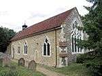 Church of St Margaret (St Mary) |
| Church of St Mary the Virgin | Stapleford | Parish Church | Mid 12th century | 24 November 1966 | TL3119216863 51°50′06″N 0°05′50″W |
1089119 | 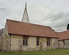 Church of St Mary the Virgin |
| Church of St Michael and All Angels | Waterford, Stapleford | Parish Church | 1871-2 | 11 June 1986 | TL3126614668 51°48′55″N 0°05′50″W |
1089122 |  Church of St Michael and All Angels |
| Marden Hill House, Service Block and Annexe | Marden Hill, Tewin | Apartment | 1986 | 20 October 1952 | TL2793613988 51°48′36″N 0°08′44″W |
1366605 | .jpg) Marden Hill House, Service Block and Annexe |
| Queen Hoo Hall | Queen Hoo Hall, Tewin | Country House | c1575-80 | 20 October 1952 | TL2787416129 51°49′45″N 0°08′45″W |
1089097 | .jpg) Queen Hoo Hall |
| Aisled Barn at Thorley Hall 60m north of House | Thorley | Aisled Barn | 16th century or earlier | 22 February 1967 | TL4766218910 51°50′57″N 0°08′33″E |
1213945 | |
| Thorley Hall | Thorley | House | c1390-1414 | 19 October 1951 | TL4768818844 51°50′55″N 0°08′34″E |
1213803 |  Thorley Hall |
| Twyford House | Twyford House, Thorley | Apartment | 1970 | 22 February 1967 | TL4933119306 51°51′09″N 0°10′00″E |
1213957 | |
| Balhams Hall and the Cottage | High Cross, Thundridge | House | 15th century | 24 January 1967 | TL3626118515 51°50′55″N 0°01′23″W |
1347496 | |
| Fabdens (on North Bank of River Rib) | Thundridge | House | Late 15th century | 24 January 1967 | TL3718017306 51°50′15″N 0°00′37″W |
1175911 | |
| Farmhouse at Sutes Farm | High Cross, Thundridge | Farmhouse | 14th century | 4 December 1951 | TL3664119000 51°51′10″N 0°01′03″W |
1347494 | |
| Hanbury Manor | Thundridge | Country House | 1890-1 | 24 January 1967 | TL3512016289 51°49′44″N 0°02′26″W |
1204101 | |
| Remains of Old Church of St Mary and All Saints | Thundridge Bury, Thundridge | Wall | 17th century | 24 January 1967 | TL3681017335 51°50′16″N 0°00′56″W |
1077953 | 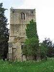 Remains of Old Church of St Mary and All Saints |
| Sawtrees Manor | Thundridge | Hall House | 15th century or Earlier | 24 January 1967 | TL3873017973 51°50′35″N 0°00′45″E |
1204250 | |
| Stable Block at Youngsbury (60m north of House) | High Cross, Thundridge | Stable | c. 1769 | 24 January 1967 | TL3688417957 51°50′36″N 0°00′52″W |
1176876 | |
| The Old Waggon | Thundridge | House | Late Medieval | 24 January 1967 | TL3628318516 51°50′55″N 0°01′22″W |
1102369 | |
| Westmill House | Westmill, Thundridge | House | Early 17th century | 24 January 1967 | TL3386416299 51°49′45″N 0°03′32″W |
1205184 | |
| Dovecote at Manor Farm (30m south of House) | Walkern | Dovecote | c. 1700 | 4 February 1959 | TL2895426500 51°55′20″N 0°07′34″W |
1175945 | .jpg) Dovecote at Manor Farm (30m south of House) |
| Farmhouse at Bridgefoot Farm | Church End, Walkern | Farmhouse | Mid 15th century | 20 October 1952 | TL2918426525 51°55′20″N 0°07′22″W |
1347976 | |
| Farmhouse at Manor Farm | Walkern | Farmhouse | c. 1700 | 20 October 1952 | TL2895226539 51°55′21″N 0°07′34″W |
1348003 | |
| Farmhouse at Rooks Nest Farm | Finches End, Walkern | Farmhouse | Mid 17th century | 20 October 1952 | TL2868725875 51°55′00″N 0°07′49″W |
1176006 | |
| Oakbeam | Walkern | House | c. 1700 | 24 November 1966 | TL2904826645 51°55′24″N 0°07′29″W |
1101353 |  Oakbeam |
| The Old Rectory (at North End of Village, to West of Church) | Walkern | House | 1984 | 24 November 1966 | TL2917226729 51°55′27″N 0°07′23″W |
1175855 |  The Old Rectory (at North End of Village, to West of Church) |
| Amwell House, Hertford Regional College | Ware | House | Early 18th century | 8 May 1950 | TL3587613962 51°48′28″N 0°01′50″W |
1274726 | .jpg) Amwell House, Hertford Regional College |
| Churchgate House | Ware | Apartment | 1995 | 14 March 1974 | TL3569714385 51°48′42″N 0°01′59″W |
1238426 | |
| Gazebo between Nos 28 and 34, Scotts Road | Ware | Gazebo | c. 1768 | 8 May 1950 | TL3567413828 51°48′24″N 0°02′01″W |
1275397 |  Gazebo between Nos 28 and 34, Scotts Road |
| Gilpin House | Ware | House | Mid 17th century | 8 May 1950 | TL3573514354 51°48′41″N 0°01′57″W |
1237905 | |
| Nos 61, 61a, 61b, and 63, High St including Doorway to No 59 (not included) | Ware | Jettied House | Late C14-Early 15th century | 8 May 1950 | TL3575814314 51°48′40″N 0°01′56″W |
1237718 | |
| The French Horn Inn | Ware | Jettied House | 16th century | 8 May 1950 | TL3584814337 51°48′40″N 0°01′51″W |
1237669 | |
| The Manor House | Ware | House | Earlier | 8 May 1950 | TL3571014485 51°48′45″N 0°01′58″W |
1221873 | |
| The Old Stables | Ware | House | 1977 | 14 March 1974 | TL3590414333 51°48′40″N 0°01′48″W |
1221845 | |
| Ware Library | Ware | Managers House | Mid-Late 18th century | 8 May 1950 | TL3565214353 51°48′41″N 0°02′01″W |
1237923 | |
| 2 West Street | Ware | Kitchen | c. 1260 | 14 March 1974 | TL3579214344 51°48′40″N 0°01′54″W |
1274208 | |
| 1 Bluecoat Yard | Ware | House | Late 17th century | 8 May 1950 | TL3589614344 51°48′40″N 0°01′48″W |
1221555 | |
| 2 Bluecoat Yard | Ware | Timber Framed House | 17th century | 8 May 1950 | TL3589614347 51°48′40″N 0°01′48″W |
1221594 | |
| 3–12 Bluecoat Yard | Ware | Houses | Mid 19th century Before 1851 | 8 May 1950 | TL3589414384 51°48′42″N 0°01′48″W |
1217408 | .jpg) 3–12 Bluecoat Yard |
| 65, 67, 67a High Street | Ware | House | C20 | 8 May 1950 | TL3573314309 51°48′39″N 0°01′57″W |
1274504 | |
| 35, 35a, 37a (part) High Street | Ware | Apartment | 1995 | 8 May 1950 | TL3585514275 51°48′38″N 0°01′51″W |
1217428 | |
| Fanhams Hall with Buildings on Courtyard | Wareside | Country House/Hotel | Early 18th century | 24 January 1967 | TL3718615656 51°49′22″N 0°00′39″W |
1281155 |  Fanhams Hall with Buildings on Courtyard |
| New Hall | Newhall Green, Wareside | House | 17th century | 24 January 1967 | TL3899616214 51°49′38″N 0°00′56″E |
1077970 |  New Hall |
| Church of St Andrew and St Mary | Watton-at-Stone | Parish Church | Earlier | 24 November 1966 | TL3024118881 51°51′12″N 0°06′37″W |
1341464 |  Church of St Andrew and St Mary |
| Watton Place and attached Garden Wall | Watton at Stone | Kitchen | 19th century | 20 October 1952 | TL2999219422 51°51′30″N 0°06′50″W |
1089070 | 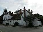 Watton Place and attached Garden Wall |
| Barn Range at Westmill Bury Farm (100m north of the Bury) | Westmill Village, Westmill | Barn | early C20 | 19 October 1951 | TL3709627172 51°55′34″N 0°00′27″W |
1174004 | |
| Parish Church of St Mary the Virgin (church of England) | Westmill | Parish Church | Pre conquest | 22 February 1967 | TL3694427171 51°55′34″N 0°00′35″W |
1173980 | 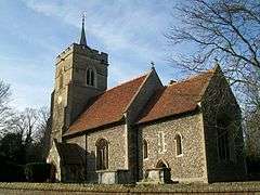 Parish Church of St Mary the Virgin (church of England) |
| Westmill Bury | Westmill | House | c. 1710 | 22 February 1967 | TL3709627069 51°55′31″N 0°00′28″W |
1347548 | |
| Parish Church of St John the Baptist | Widford | Anglican Church | 1887-8 | 24 January 1967 | TL4132615795 51°49′22″N 0°02′57″E |
1101926 | 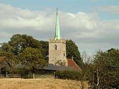 Parish Church of St John the Baptist |
| Wall forming West Boundary of Church Yard with Classical Gateway | Widford, East Hertfordshire | Gate | Mid 16th century | 24 January 1967 | TL4130115788 51°49′22″N 0°02′56″E |
1176928 | |
| Corneybury | Wyddial, East Hertfordshire | Manor House | Late 16th century | 19 October 1951 | TL3581130706 51°57′30″N 0°01′30″W |
1101809 | |
| Wyddial Hall | Wyddial | Country House | Early 16th century | 19 October 1951 | TL3740431850 51°58′05″N 0°00′05″W |
1307579 | 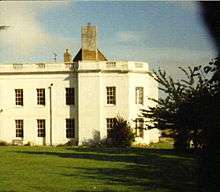 Wyddial Hall |


.jpg)

.jpg)

Notes
- The date given is the date used by Historic England as significant for the initial building or that of an important part in the structure's description.
- Sometimes known as OSGB36, the grid reference is based on the British national grid reference system used by the Ordnance Survey.
- The "List Entry Number" is a unique number assigned to each listed building and scheduled monument by Historic England.
External links
![]()
This article is issued from Wikipedia. The text is licensed under Creative Commons - Attribution - Sharealike. Additional terms may apply for the media files.