Grade II* listed buildings in Colchester (borough)
There are over 20,000 Grade II* listed buildings in England. This page is a list of these buildings in the district of Colchester in Essex.
List of buildings
| Name | Location | Type | Completed [note 1] | Date designated | Grid ref.[note 2] Geo-coordinates |
Entry number [note 3] | Image |
|---|---|---|---|---|---|---|---|
| Church of St Andrew | Abberton | Church | 14th century | 7 April 1965 | TL9974419386 51°50′14″N 0°53′52″E |
1110914 | 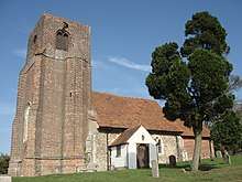 Church of St Andrew |
| Aldham Hall | Aldham | House | Early 17th century | 23 June 1952 | TL9184924860 51°53′21″N 0°47′11″E |
1306270 |  |
| Barn to north-east of Hoe Farmhouse | Aldham | Barn | c.1500 | 27 January 1982 | TL9061325774 51°53′52″N 0°46′09″E |
1170078 | |
| Church of St Margaret and St Catherine | Aldham | Church | 1854 | 7 April 1965 | TL9176325844 51°53′53″N 0°47′09″E |
1170063 | 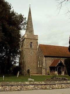 Church of St Margaret and St Catherine |
| The Old House | Aldham | House | 1751 | 7 April 1965 | TL9202226996 51°54′30″N 0°47′25″E |
1337411 | |
| Threshers | Aldham | House | Later 16th century | 7 April 1965 | TL9203826983 51°54′30″N 0°47′25″E |
1110885 | |
| Church of St Mary (ruin) North of Birch Hall | Birch | Church | 12th century | 23 June 1952 | TL9500720770 51°51′05″N 0°49′48″E |
1110898 | _North_of_Birch_Hall.JPG) Church of St Mary (ruin) North of Birch Hall |
| Badcocks Farmhouse | Copford | Farmhouse | Late 15th century | 23 June 1952 | TL9004321086 51°51′22″N 0°45′29″E |
1239073 | |
| Easthorpe Hall | Copford | House | 17th century | 23 June 1952 | TL9116621513 51°51′34″N 0°46′29″E |
1273949 | |
| St Mary's Grange | Copford | House | Late 15th century | 23 June 1952 | TL9161521602 51°51′36″N 0°46′53″E |
1239072 | |
| Brook House | Dedham | Jettied house | 16th century | 23 June 1952 | TM0583333190 51°57′33″N 0°59′40″E |
1239284 | |
| Dale Brook | Dedham | House | c.1780 | 23 June 1952 | TM0582133190 51°57′33″N 0°59′39″E |
1239313 | |
| Essex Rose Cafe | Dedham | Jettied house | 15th/16th century | 23 June 1952 | TM0575433196 51°57′33″N 0°59′36″E |
1239326 | |
| Gould House | Dedham | House | 18th century | 23 June 1952 | TM0581033187 51°57′33″N 0°59′39″E |
1273803 |  Gould House |
| Great House | High Street, Dedham | House | 1937–38 | 6 July 1981 | TM0557733100 51°57′30″N 0°59′26″E |
1239335 |  Great House |
| House and shop occupied by F R Spearing next to Shermans | Dedham | House | 18th century | 23 June 1952 | TM0571333173 51°57′32″N 0°59′33″E |
1273804 | |
| Ivy House | Dedham | House | 1767 | 23 June 1952 | TM0573733181 51°57′33″N 0°59′35″E |
1239286 | 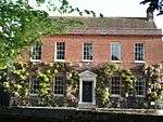 Ivy House |
| Knights Manor | Dedham | Manor house | 16th century | 23 June 1952 | TM0613332234 51°57′01″N 0°59′53″E |
1273808 | |
| Le Talbooth | Gun Hill, Dedham | Jettied house | 16th century | 22 November 1967 | TM0421933464 51°57′44″N 0°58′16″E |
1239265 | 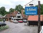 Le Talbooth |
| Loom House & Marlborough Head Inn | Dedham | Houses | Later | 23 June 1952 | TM0578633184 51°57′33″N 0°59′37″E |
1239285 | 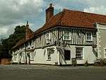 Loom House & Marlborough Head Inn |
| Rye Farmhouse | Dedham | Farmhouse | c.1400 | 27 January 1982 | TM0473031516 51°56′40″N 0°58′38″E |
1239440 | |
| Shakespeare House | Dedham | House | Later | 23 June 1952 | TM0565733151 51°57′32″N 0°59′30″E |
1239331 | 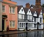 Shakespeare House |
| Sheldrakes | Dedham | House | 18th century | 7 April 1965 | TM0566333132 51°57′31″N 0°59′31″E |
1239317 | |
| The Sun Public House | Dedham | Jettied house | 14th century | 23 June 1952 | TM0568233174 51°57′32″N 0°59′32″E |
1273783 | 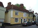 The Sun Public House |
| Vale Bakery | Dedham | Bakery | Late medieval | 7 April 1965 | TM0562133123 51°57′31″N 0°59′28″E |
1239332 |  Vale Bakery |
| 1 High Street | Dedham | Timber-framed house | 18th century | 23 June 1952 | TM0584433191 51°57′33″N 0°59′40″E |
1239312 | |
| Barnards Farmhouse | Fordham | Farmhouse | 14th century | 27 January 1982 | TL9198627322 51°54′41″N 0°47′23″E |
1239874 | |
| Wash Farmhouse | Fordham | Farmhouse | 13th century | 27 January 1982 | TL9190627384 51°54′43″N 0°47′19″E |
1239836 | |
| Church of St Nicholas | Little Wigborough, Great and Little Wigborough | Church | 15th century | 7 April 1965 | TL9809114540 51°47′40″N 0°52′16″E |
1223007 | 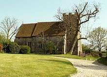 Church of St Nicholas |
| Church of St Stephen | Great Wigborough, Great and Little Wigborough | Church | 14th century | 7 April 1965 | TL9680715640 51°48′17″N 0°51′11″E |
1223003 | 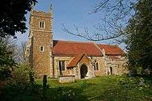 Church of St Stephen |
| Chapel Cottage | Great Horkesley | House | 15th century | 23 June 1952 | TL9772130967 51°56′31″N 0°52′31″E |
1222607 |  Chapel Cottage |
| Cockerills | Great Horkesley | Cross-wing house | 14th century | 7 April 1965 | TL9772831610 51°56′52″N 0°52′32″E |
1222741 | |
| Gulls Farmhouse | Great Tey | Farmhouse | 15th century | 27 January 1982 | TL8715024732 51°53′23″N 0°43′06″E |
1267431 | |
| The Hall | Langham | House | c.1740 | 27 January 1982 | TM0322233656 51°57′51″N 0°57′24″E |
1223465 | |
| Valley House | Langham | House | 17th century | 23 June 1952 | TM0199634291 51°58′13″N 0°56′21″E |
1223746 | |
| Layer Breton Hall | Layer Breton | House | Mid-18th century | 27 January 1982 | TL9486517131 51°49′08″N 0°49′33″E |
1267120 | |
| Duke's Farmhouse | Layer Marney | Farmhouse | 16th century | 23 June 1952 | TL9305918267 51°49′47″N 0°48′01″E |
1267081 |  Duke's Farmhouse |
| Wick Farmhouse | Layer Marney | Cross-wing house | 15th century | 27 January 1982 | TL9308517484 51°49′21″N 0°48′01″E |
1223989 | |
| Blind Knights | Layer-de-la-Haye | House | Early 15th century | 18 May 1979 | TL9763219069 51°50′07″N 0°52′02″E |
1267086 | |
| Malting Green House | Layer-de-la-Haye | House | Early 18th century | 27 January 1982 | TL9756119950 51°50′35″N 0°52′00″E |
1223909 |  Malting Green House |
| Holt's Farmhouse | Little Horkesley | Farmhouse | c. 1750 (frontage) | 27 January 1982 | TL9479131125 51°56′40″N 0°49′58″E |
1223990 | |
| King's Farmhouse | Little Horkesley | Farmhouse | 15th century or earlier | 7 April 1965 | TL9629631698 51°56′57″N 0°51′18″E |
1224018 |  King's Farmhouse |
| Little Horkesley Hall | Little Horkesley | House | 18th century | 27 January 1982 | TL9599931868 51°57′03″N 0°51′02″E |
1267036 | |
| Old Josselyns | Little Horkesley | House | Modern | 23 June 1952 | TL9639232612 51°57′26″N 0°51′25″E |
1266816 | 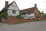 Old Josselyns |
| The Priory | Little Horkesley | Farmhouse | 17th century | 27 January 1982 | TL9607431991 51°57′07″N 0°51′07″E |
1224435 | |
| Westwood Park | Little Horkesley | Country house | 17th century | 27 January 1982 | TL9619529988 51°56′02″N 0°51′09″E |
1267009 | |
| Barn south of Marks Tey Hall | Marks Tey | Barn | c.1400 | 27 January 1982 | TL9168123306 51°52′31″N 0°46′59″E |
1224577 | |
| Barn to south-west of Little Tey House | Marks Tey | Aisled barn | 16th century | 27 January 1982 | TL8928924405 51°53′10″N 0°44′57″E |
1266779 | |
| Church of All Saints | Messing, Messing-cum-Inworth | Church | 13th century | 7 April 1965 | TL8968518930 51°50′12″N 0°45′07″E |
1224665 | 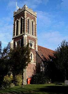 Church of All Saints |
| Messing Park | Messing Park, Messing-cum-Inworth | House | Early 18th century | 7 April 1965 | TL8939318026 51°49′43″N 0°44′50″E |
1224649 | |
| Games Farmhouse | Peldon | Farmhouse | Early 15th century | 27 January 1982 | TL9879516278 51°48′35″N 0°52′56″E |
1266661 | |
| Church of St Mary | Salcott cum Virley | Church | 14th century | 7 April 1965 | TL9519713590 51°47′13″N 0°49′43″E |
1224767 | 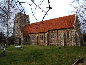 Church of St Mary |
| Beaconhead Farmhouse | Stanway | Farmhouse | 14th century | 27 January 1982 | TL9530024803 51°53′15″N 0°50′11″E |
1224842 | Beaconhead Farmhouse |
| Catchbells | Stanway | House | c.1500 | 27 January 1982 | TL9411224407 51°53′04″N 0°49′09″E |
1224841 |  Catchbells |
| Church of All Saints | Stanway | Church | Late 13th century | 16 June 1999 | TL9532022056 51°51′46″N 0°50′07″E |
1266610 | 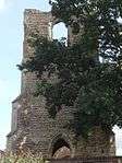 Church of All Saints |
| Olivers | Stanway | House | 17th century | 7 April 1965 | TL9670721437 51°51′25″N 0°51′18″E |
1224900 | |
| Parish Church of St Albright | Stanway | Parish church | 12th century | 7 April 1965 | TL9403924318 51°53′01″N 0°49′05″E |
1224899 | 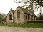 Parish Church of St Albright |
| Church of All Saints | Wakes Colne | Parish church | Norman | 7 April 1965 | TL8896628605 51°55′26″N 0°44′48″E |
1225059 | 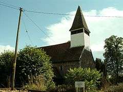 Church of All Saints |
| Normans Farmhouse | Wakes Colne | Farmhouse | c.1300 | 27 January 1982 | TL8865530347 51°56′23″N 0°44′35″E |
1225019 | |
| Old House | Wakes Colne | House | 17th century | 27 January 1982 | TL8975029170 51°55′43″N 0°45′30″E |
1225029 | 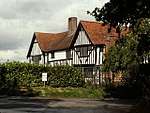 Old House |
| Watch House | Wakes Colne | Open hall house | c.1520 | 27 January 1982 | TL8957128540 51°55′23″N 0°45′20″E |
1224980 | 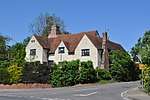 Watch House |
| Cooks Hall | West Bergholt | House | 16th century | 27 January 1982 | TL9500527364 51°54′38″N 0°50′01″E |
1225091 |  Cooks Hall |
| High Trees Farmhouse | West Bergholt | Farmhouse | Early 15th century | 23 June 1952 | TL9590728276 51°55′07″N 0°50′50″E |
1225133 | |
| Horsepits Farmhouse | West Bergholt | Farmhouse | 16th century or earlier | 23 June 1952 | TL9543927112 51°54′30″N 0°50′23″E |
1266529 | |
| The Hall | West Bergholt | House | 18th century | 7 April 1965 | TL9523728060 51°55′01″N 0°50′15″E |
1266531 | .jpg) The Hall |
| Yew Tree House, gate and gatepiers | West Mersea | House | Early 18th century | 11 October 1949 | TM0084012476 51°46′30″N 0°54′35″E |
1266512 | |
| The Church of St Mary | Wivenhoe | Parish church | Mid-14th century | 3 May 1949 | TM0389921524 51°51′18″N 0°57′34″E |
1225318 |  The Church of St Mary |
| Jenkins Farmhouse | Wormingford | Farmhouse | 16th century | 23 June 1952 | TL9308130723 51°56′29″N 0°48′27″E |
1225427 | 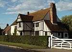 Jenkins Farmhouse |
| Rochfords | Wormingford | House | 16th century | 23 June 1952 | TL9329730373 51°56′18″N 0°48′38″E |
1225428 | |
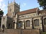
| Church of St James the Great | Colchester | Church | 13th to 15th century | 24 February 1950 | TM0016525238 51°53′23″N 0°54′27″E |
1307051 | .JPG) Church of St James the Great |
| Church of St Michael | Berechurch | Bell tower | 14th century | 24 February 1950 | TL9928521888 51°51′36″N 0°53′34″E |
1123672 | 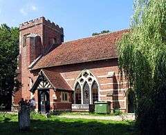 Church of St Michael |
| Church of St Peter | Colchester | Church | Early 15th century | 24 February 1950 | TL9943525240 51°53′24″N 0°53′48″E |
1123570 | 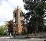 Church of St Peter |
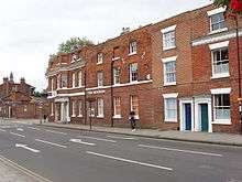
| Colchester Club | Colchester | House | Mid-18th century | 24 February 1950 | TL9992825170 51°53′21″N 0°54′14″E |
1337710 | 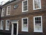 Colchester Club |
| Column and street light, left of entrance to Town Hall | Colchester | Column | c.1898 | 8 September 1993 | TL9958525213 51°53′23″N 0°53′56″E |
1230447 | 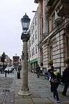 Column and street light, left of entrance to Town Hall |
| Column and street light, right of entrance to Town Hall | Colchester | Column | c.1898 | 8 September 1993 | TL9959425215 51°53′23″N 0°53′57″E |
1230446 |  Column and street light, right of entrance to Town Hall |
| Employment Exchange | Colchester | House | Early 18th century | 2 December 1971 | TL9964825319 51°53′26″N 0°54′00″E |
1337704 | 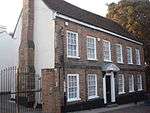 Employment Exchange |
| Essex and Suffolk Fire Office | Colchester | Corn exchange | 1820 | 24 February 1950 | TL9943725211 51°53′23″N 0°53′48″E |
1306789 | 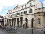 Essex and Suffolk Fire Office |
| Former Church of St Leonard at the Hythe | Hythe | Church | 12th century | 24 February 1950 | TM0128024719 51°53′05″N 0°55′24″E |
1123578 | |
| Former Church of St Martin | Colchester | Church | Early 12th century (origin) | 2 December 1971 | TL9961025347 51°53′27″N 0°53′58″E |
1337393 | 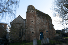 Former Church of St Martin |
| Garrison Church | Colchester Garrison | Military chapel | 1856 | 2 December 1971 | TM0039524387 51°52′55″N 0°54′37″E |
1123564 | 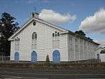 Garrison Church |
| Grey Friars | Colchester | House | 18th century | 24 February 1950 | TM0005725268 51°53′24″N 0°54′21″E |
1123611 | 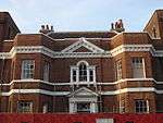 Grey Friars |
| Headgate Court, Colchester | Colchester | Courtyard | 16th–17th century | 24 February 1950 | TL9936025041 51°53′18″N 0°53′44″E |
1337707 | 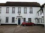 Headgate Court, Colchester |
| Municipal Water Tower ("Jumbo") | Colchester | Water tower | 1882 | 2 December 1971 | TL9932125182 51°53′22″N 0°53′42″E |
1123669 | 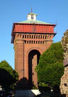 Municipal Water Tower ("Jumbo") |
| Rear wing of the Old Siege House | Colchester | House | Early 19th century | 2 December 1971 | TM0072825326 51°53′25″N 0°54′56″E |
1123628 |  Rear wing of the Old Siege House |
| Summerhouse at Number 74 (the Minories) | Colchester | Summerhouse | Mid-18th century | 19 February 1959 | TM0001325176 51°53′21″N 0°54′18″E |
1123608 | .JPG) Summerhouse at Number 74 (the Minories) |
| The George Hotel | Colchester | House | 17th century | 24 February 1950 | TL9973525258 51°53′24″N 0°54′04″E |
1123614 | 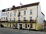 The George Hotel |
| The Marquis of Granby Inn | Colchester | Inn | Early 16th century | 24 February 1950 | TL9941125469 51°53′32″N 0°53′48″E |
1123534 |  The Marquis of Granby Inn |
| The Minories | Colchester | House | Later 18th century | 24 February 1950 | TM0000925230 51°53′23″N 0°54′18″E |
1123607 | |
| The Scheregate | Colchester | Timber-framed house | 17th century | 24 February 1950 | TL9962125012 51°53′16″N 0°53′58″E |
1337769 |  The Scheregate |
| The Siege House | Colchester | House | Early 16th century | 19 February 1959 | TM0073825318 51°53′25″N 0°54′57″E |
1123627 | 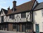 The Siege House |
| Tymperleys | Colchester | House | 15th–16th century | 24 February 1950 | TL9957325084 51°53′19″N 0°53′55″E |
1169553 |  Tymperleys |
| Wivenhoe House | Wivenhoe Park | Country house | 1759 | 1 June 1973 | TM0327524120 51°52′43″N 0°57′07″E |
1225229 | 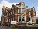 Wivenhoe House |
| 3–5 West Stockwell Street | Colchester | Timber-framed house | Late 15th century | 19 February 1959 | TL9960225278 51°53′25″N 0°53′57″E |
1110922 | 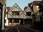 3–5 West Stockwell Street |
| 29–31 West Stockwell Street | Colchester | Timber-framed house | c.1600 | 24 February 1950 | TL9954225466 51°53′31″N 0°53′54″E |
1110929 | 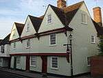 29–31 West Stockwell Street |
| 54 Head Street | Colchester | House | 1774 | 24 February 1950 | TL9943225035 51°53′17″N 0°53′48″E |
1123596 | 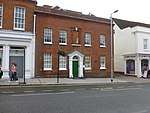 54 Head Street |
| 11A and 11B High Street | Colchester | House | 17th century | 24 February 1950 | TL9948925169 51°53′22″N 0°53′51″E |
1123597 | 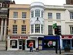 11A and 11B High Street |
| 71 Culver Street | Colchester | House | 18th century | 24 February 1950 | TL9994225169 51°53′21″N 0°54′15″E |
1123644 | 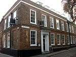 71 Culver Street |
| 20 and 22 Crouch Street | Colchester | House | Mid-18th century | 24 February 1950 | TL9927524953 51°53′15″N 0°53′39″E |
1123643 | 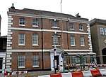 20 and 22 Crouch Street |
| 9 and 10 East Hill | Colchester | Town house | Early Georgian | 24 February 1950 | TM0027325224 51°53′22″N 0°54′32″E |
1123650 | 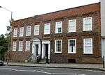 9 and 10 East Hill |
| 60 North Hill | Colchester | House | 17th century | 24 February 1950 | TL9938425270 51°53′25″N 0°53′46″E |
1169334 |  60 North Hill |
| 6 Trinity Street | Colchester | House | 18th century | 1 August 1968 | TL9959525105 51°53′20″N 0°53′56″E |
1337771 |  6 Trinity Street |
| 13–15 North Hill | Colchester | Shop | Later 19th century | 24 February 1950 | TL9942025377 51°53′29″N 0°53′48″E |
1337776 | 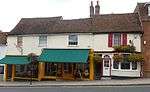 13–15 North Hill |
| 17 Sir Isaac's Walk | Colchester | Cellar | Medieval | 24 February 1950 | TL9943525012 51°53′17″N 0°53′48″E |
1337728 | 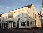 17 Sir Isaac's Walk |
| Colchester War Memorial | Colchester | War memorial | 1923 | 7 July 2006 | TL9992525247 51°53′24″N 0°54′14″E |
1391704 | 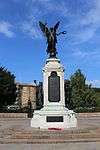 Colchester War Memorial |
See also
- Grade I listed buildings in Essex
- Grade II* listed buildings in Essex
- Grade II* listed buildings in Basildon (district)
- Grade II* listed buildings in Braintree (district)
- Grade II* listed buildings in Brentwood (borough)
- Grade II* listed buildings in Castle Point
- Grade II* listed buildings in Chelmsford (borough)
- Grade II* listed buildings in Epping Forest (district)
- Grade II* listed buildings in Harlow
- Grade II* listed buildings in Maldon (district)
- Grade II* listed buildings in Rochford (district)
- Grade II* listed buildings in Southend-on-Sea
- Grade II* listed buildings in Tendring
- Grade II* listed buildings in Thurrock
- Grade II* listed buildings in Uttlesford
- Churches in Colchester
Notes
- The date given is the date used by Historic England as significant for the initial building or that of an important part in the structure's description.
- Sometimes known as OSGB36, the grid reference is based on the British national grid reference system used by the Ordnance Survey.
- The "List Entry Number" is a unique number assigned to each listed building and scheduled monument by Historic England.
External links
![]()
This article is issued from Wikipedia. The text is licensed under Creative Commons - Attribution - Sharealike. Additional terms may apply for the media files.