Geography of Slovakia
Slovakia is a landlocked Central European country with mountainous regions in the north and flat terrain in the south.
Statistics
Land use:
agricultural land: 40.1%
arable land: 28.9%; permanent crops: 0.4%; permanent pasture: 10.8%
forest: 40.2%
other: 19.7% (2011 est.)
Natural resources:
Lignite, small amounts of iron ore, copper and manganese ore; salt; arable land
Natural Hazards:
Flooding
Environment-international agreements:
Party to: Air Pollution, Air Pollution-Nitrogen Oxides, Air Pollution-Persistent Organic Pollutants, Air Pollution-Sulfur 85, Air Pollution-Sulfur 94, Air Pollution-Volatile Organic Compounds, Antarctic Treaty, Biodiversity, Climate Change, Climate Change-Kyoto Protocol, Desertification, Endangered Species, Environmental Modification, Hazardous Wastes, Law of the Sea, Ozone Layer Protection, Ship Pollution, Wetlands, Whaling.
Signed, but not ratified: none of the selected agreements
Area
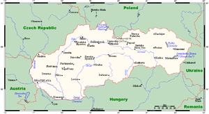
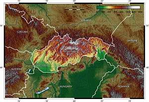
Slovakia lies between 49°36'48" and 47°44'21" northern latitude and 16°50'56" and 22°33'53" eastern longitude.
The northernmost point is near Beskydok, a mountain on the border with Poland near the village of Oravská Polhora in the Beskids. The southernmost point is near the village of Patince on the Danube on the border with Hungary. The westernmost point is on the Morava River near Záhorská Ves on the Austrian border. The easternmost point is close to the summit of Kremenec, a mountain near the village of Nová Sedlica at the meeting point of Slovak, Polish, and Ukrainian borders.

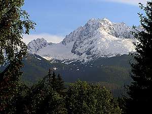
The highest point is at the summit of Gerlachovský štít in the High Tatras, 2,655 m (8,710.6 ft), the lowest point is the surface of the Bodrog River on the Hungarian border at 94 m (308.4 ft).
The country's area is 48,845 km2 (18,859 sq mi). 31% is arable land, 17% pastures, 41% forests, 3% cultivated land. The remaining 8% is mostly covered with human structures and infrastructure, and partly with rocky mountain ridges and other unimproved land.[1]
Slovakia borders Poland in the north - 547 km (339.9 mi), Ukraine in the east - 98 km (60.9 mi), Hungary in the south - 679 km (421.9 mi), Austria in the south-west - 106 km (65.9 mi), and the Czech Republic in the north-west - 252 km (156.6 mi) for a total border length of 1,672 km (1,038.9 mi).[2]
Climate
Temperate; cool summers; cold, cloudy, humid winters.
References
- bedekr.cz
- Slovak Wikipedia: sk:Slovensko#Hranice
![]()
| Wikimedia Commons has media related to Geography of Slovakia. |
Slovakia articles | ||||||||
|---|---|---|---|---|---|---|---|---|
| History |
|  | ||||||
| Geography |
| |||||||
| Politics |
| |||||||
| Economy | ||||||||
| Society |
| |||||||
| ||||||||
| Countries |  | |
|---|---|---|
| Cities | ||
| Tributaries | ||
| Canals | ||
| See also | ||