Geography of Europe
Europe is traditionally defined as one of seven continents. Physiographically, it is the northwestern peninsula of the larger landmass known as Eurasia (or the larger Afro-Eurasia); Asia occupies the eastern bulk of this continuous landmass and all share a common continental shelf. Europe's eastern frontier is delineated by the Ural Mountains in Russia. The southeast boundary with Asia is not universally defined, but the modern definition is generally the Ural River or, less commonly, the Emba River. The boundary continues to the Caspian Sea, the crest of the Caucasus Mountains (or, less commonly, the river Kura in the Caucasus), and on to the Black Sea. The Bosporus, the Sea of Marmara, and the Dardanelles conclude the Asian boundary. The Mediterranean Sea to the south separates Europe from Africa. The western boundary is the Atlantic Ocean. Iceland, though on the Mid-Atlantic Ridge and nearer to Greenland (North America) than Mainland Europe, is generally included in Europe for cultural reasons and because it is over twice as close to mainland Europe as mainland North America. There is ongoing debate on where the geographical centre of Europe falls.
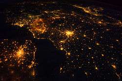 Several of the oldest cities of Northwestern Europe are highlighted in this astronaut's photograph from 00:25 GMT on 10 August 2011 .svg.png) | |
| Area | 10,180,000 km2 (3,930,000 sq mi)[n] (6th) |
|---|---|
| Population | 742,452,000[n] (2013; 3rd) |
| Population density | 72.9/km2 (188/sq mi) (2nd) |
| Demonym | European |
| Countries | 50 sovereign states 5 with limited recognition |
| Dependencies | 4 dependencies |
| Languages | ~225 languages[1] |
| Time zones | UTC−1 to UTC+5 |
Overview
Some geographical texts refer to a Eurasian continent given that Europe is not surrounded by sea and its southeastern border has always been variously defined for centuries.
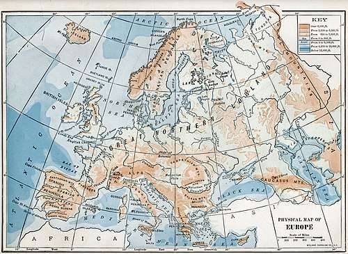
In terms of shape, Europe is a collection of connected peninsulas and nearby islands. The two largest peninsulas are mainland Europe and Scandinavia to the north, divided from each other by the Baltic Sea. Three smaller peninsulas—Iberia, Italy, and the Balkans—emerge from the southern margin of the mainland. The Balkan peninsula is separated from Asia by the Black and Aegean Seas. Italy is separated from the Balkans by the Adriatic Sea, and from Iberia by the Mediterranean Sea, which also separates Europe from Africa. Eastward, mainland Europe widens much like the mouth of a funnel, until the boundary with Asia is reached at the Ural Mountains and Ural River, the Caspian Sea, and the Caucasus Mountains.
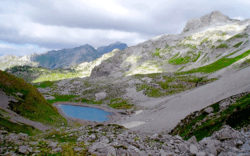
Land relief in Europe shows great variation within relatively small areas. The southern regions are mountainous while moving north the terrain descends from the high Alps, Pyrenees, and Carpathians, through hilly uplands, into broad, low northern plains, which are vast in the east. An arc of uplands also exists along the northwestern seaboard, beginning in southwestern Ireland, continuing across through western and northern Great Britain, and up along the mountainous, fjord-cut spine of Norway.
This description is simplified. Sub-regions such as Iberia and Italy contain their own complex features, as does mainland Europe itself, where the relief contains many plateaus, river valleys, and basins that complicate the general trend. Iceland and the British Isles are special cases. The former is of North Atlantic volcanic formation, while the latter consist of upland areas once joined to the mainland until cut off by rising sea levels.
Peninsula of peninsulas
Europe is sometimes called a "peninsula of peninsulas", to draw attention to the fact that Europe is a relatively small, elongated appendage to Asia, and that a large part of Europe is made up of peninsulas.[2] A prehistoric perspective would include Britain and Ireland as the core of a further very significant European peninsula prior to the post-glacial rise in sea-levels.[3]
Partial list of European peninsulas
- Absheron peninsula
- Balkan peninsula
- Cotentin Peninsula
- Crimea
- Fennoscandian Peninsula
- Iberian Peninsula
- Italian Peninsula
- Jutland
- Kanin Peninsula
Geology
Europe's most significant geological feature is the dichotomy between the highlands and mountains of Southern Europe and a vast, partially underwater, northern plain ranging from Great Britain in the west to the Ural Mountains in the east. These two halves are separated by the mountain chains of the Pyrenees and the Alps/Carpathians. The northern plains are delimited in the west by the Scandinavian mountains and the mountainous parts of the British Isles. The major shallow water bodies submerging parts of the northern plains are the Celtic Sea, the North Sea, the Baltic Sea complex, and the Barents Sea.
The northern plain contains the old geological continent of Baltica, and so may be regarded as the "main continent", while peripheral highlands and mountainous regions in south and west constitute fragments from various other geological continents.
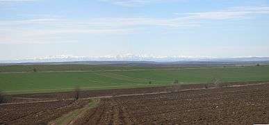
The geology of Europe is hugely varied and complex, and gives rise to the wide variety of landscapes found across the continent, from the Scottish Highlands to the rolling plains of Hungary.
Population
Figures for the population of Europe vary according to which definition of European boundaries is used. The population within the standard physical geographical boundaries was 701 million in 2005 according to the United Nations. In 2000 the population was 857 million, using a definition which includes the whole of the transcontinental countries of Russia and Turkey. Population growth is comparatively slow, and median age comparatively high in relation to the world's other continents.
Rivers
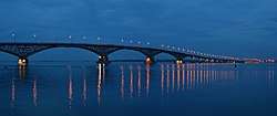
The most important rivers in Europe are Danube, Volga, Rhine, Elbe, Oder and Dnieper, among others.
European rivers by length
The longest rivers in Europe, directly flowing into the World Ocean or Endorheic basins, with their approximate lengths:[4][5]
- Volga - 3,690 km (2,290 mi)
- Danube - 2,860 km (1,780 mi)
- Ural - 2,428 km (1,509 mi)
- Dnieper - 2,290 km (1,420 mi)
- Don - 1,950 km (1,210 mi)
- Pechora - 1,809 km (1,124 mi)
- Kama - 1,805 km (1,122 mi)
- Oka - 1,500 km (930 mi)
- Dniester - 1,352 km (840 mi)
- Rhine - 1,236 km (768 mi)
- Elbe - 1,091 km (678 mi)
- Vistula - 1,047 km (651 mi)
- Tagus - 1,038 km (645 mi)
- Daugava - 1,020 km (630 mi)
- Loire - 1,012 km (629 mi)
- Ebro - 960 km (600 mi)
- Prut - 953 km (592 mi)
- Neman - 937 km (582 mi)
- Meuse - 925 km (575 mi)
- Douro - 897 km (557 mi)
- Kuban River - 870 km (540 mi)
- Mezen - 857 km (533 mi)[6]
- Oder - 854 km (531 mi)
- Guadiana - 829 km (515 mi)
- Rhône - 815 km (506 mi)
- Kuma - 802 km (498 mi)
- Seine - 776 km (482 mi)
- Mureș - 761 km (473 mi)
- Northern Dvina - 744 km (462 mi)
- Po - 682 km (424 mi)
- Guadalquivir - 657 km (408 mi)
- Bolshoy Uzen - 650 km (400 mi)
- Siret - 647 km (402 mi)
- Terek - 623 km (387 mi)
- Glomma - 604 km (375 mi) (Norway's longest and most voluminous river)
- Garonne - 602 km (374 mi)
- Kemijoki - 550 km (340 mi)
- Torne - 522 km (324 mi)
- Dalälven - 520 km (320 mi)
- Maritsa - 515 km (320 mi)
- Marne - 514 km (319 mi) (major tributary of the Seine)
- Neris - 510 km (320 mi)
- Júcar - 509 km (316 mi)
- Dordogne - 483 km (300 mi)
- Ume - 470 km (290 mi)
- Ångerman - 460 km (290 mi) (Sweden's longest rivers)
- Lule - 460 km (290 mi)
- Gauja - 452 km (281 mi)
- Weser - 452 km (281 mi)
- Kalix - 450 km (280 mi)
European rivers by discharge
The 15 rivers of Europe by average discharge, including only rivers directly flowing into the World Ocean or Endorheic basins:
- Volga - 8,087 m³/s (largest river in Eastern Europe)
- Danube - 6,450 m³/s (largest river in Central Europe)
- Pechora - 4,380m³/s
- Northern Dvina - 3,330m³/s
- Neva - 2,490 m³/s
- Rhine - 2,315 m³/s) (largest river in Western Europe)
- Rhône - 1,900 m³/s (largest river in France)
- Dnieper - 1,700 m³/s
- Po - 1,460 m³/s (largest river in Italy)
- Vistula - 1,080 m³/s
- Don - 890 m³/s
- Mezen - 890 m³/s
- Loire - 889 m³/s (longest river in France)
- Elbe - 860 m³/s
- Glomma - 709 m³/s (Norway's longest and most voluminous river)
Lakes and inland seas
Major islands
Iceland, Faroe Islands, Great Britain, Ireland, Balearic Islands, Corsica, Sardinia, Sicily, Malta, Cyprus (adjecent to Asia), Ionian Islands, Crete, Aegean Islands, Åland Islands, Gotland, Saaremaa, Svalbard, Hinnøya, Senja, Zealand, Fyn and North Jutlandic Island.
See also List of European islands by area and List of European islands by population
Plains and lowlands
- Great European Plain, the largest landscape feature of Europe
- East European Plain
- Lower Danubian Plain, between Balkan Mountains and Southern Carpathians
- North European Plain
- North German Plain (German section)
- Beauce, France
- East European Plain
- Baetic Depression (Andalusian Plain), between Sierra Morena and Baetic System
- British Lowlands
- Central Swedish lowland
- Ebro Basin (Ebro Depression), between Pyrenees and Sistema Ibérico
- Meseta Central is a high plain plateau in central Spain (occupies roughly 40% of the country), between Cantabrian Mountains and Sistema Central
- Pannonian Plain, between Alps, Dinaric Mountains and Carpathian Mountains
- Po Valley, also known as Padan Plain, between Alps and Apennines
- Swiss Central Plateau, between the Jura Mountains and Swiss Alps
- Upper Rhine Plain, between Vosges Mountains and Black Forest Mountains
- Upper Thracian Plain, between Balkan Mountains (Sredna Gora) and Rila-Rhodope massif
- Other European coastal plains
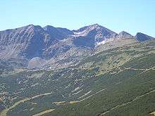
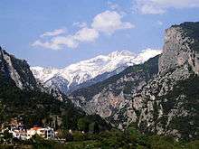
Mountain ranges
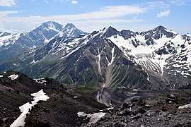
Some of Europe's major mountain ranges are:
- Alps, in Central Western Europe
- Apennines, which run through Italy
- Baetic System, Spain, Iberian Peninsula
- Balkan Mountains, mainly Bulgaria, central Balkan Peninsula
- Sredna Gora Mountain range in central Bulgaria, situated south of and parallel to the Balkan Mountains
- Bohemian and other Variscan massifs (pre-Alpine mountain ranges) - Jura Mountains, Vosges, Palatinate Forest, Black Forest, Ore Mountains, Sudetes
- Cantabrian Mountains, which run across northern Spain
- Carpathian Mountains, a major mountain range in Central and Southern Europe
- Caucasus Mountains, which also separate Europe and Asia
- Crimean Mountains
- Dinaric Alps, a mountain range in the Balkans
- Pindus Mountains, Albania and Greece
- Pyrenees, the natural border between France and Spain
- Rila-Rhodope mountain system composed by massifs, including Pirin Mountain and Osogovo-Belasitsa mountain chain, mainly Bulgaria
- Šar-Korab-Jakupica-Baba-Kajmakčalan-Olympus, Albania, Northern Macedonia and Greece[7]
- Scandinavian Mountains, a mountain range which runs through the Scandinavian Peninsula, includes the Kjølen mountains
- Scottish Highlands (including the Cairngorms) in the United Kingdom.
- Sierra Morena, Spain
- Sistema Ibérico, Spain
- Sistema Central, Spain
- Ural Mountains, which form the boundary between Europe and Asia
Land area in different classes of European mountainous terrain (classification from UNEP-WCMC):
| Altitude | Area (km2) | % Area |
|---|---|---|
| ≥4500m | 1 | 0.00% |
| 3500-4500m | 225 | 0.00% |
| 2500-3500m | 497,886 | 4.89% |
| 1500-2500m & slope ≥2° | 145,838 | 1.43% |
| 1000-1500m & slope ≥5° or local elevation range >300m |
345,255 | 3.39% |
| 300-1000m and local elevation range >300m |
1,222,104 | 12.00% |
| Mountainous TOTAL | 2,211,308 | 21.72% |
| Europe TOTAL | 10,180,000 | 100.00% |
Temperature and precipitation
The high mountainous areas of Europe are colder and have higher precipitation than lower areas, as is true of mountainous areas in general. Europe has less precipitation in the east than in central and western Europe. The temperature difference between summer and winter gradually increases from coastal northwest Europe to southeast inland Europe, ranging from Ireland, with a temperature difference of only 10 °C from the warmest to the coldest month, to the area north of the Caspian Sea, with a temperature difference of 40 °C. January average range from 13 °C in southern Spain and southern Greek islands to -20 °C in the northeastern part of European Russia. Desert climates are found in the European portion of Kazakhstan and South Eastern Spain.
Western Europe and parts of Central Europe generally fall into the temperate maritime climate (Cfb), the southern part is mostly a Mediterranean climate (mostly Csa, smaller area with Csb), the north-central part and east into central Russia is mostly a humid continental climate (Dfb) and the northern part of the continent is a subarctic climate (Dfc). In the extreme northern part (northernmost Russia; Svalbard), bordering the Arctic Ocean, is tundra climate (Et). Mountain ranges, such as the Alps and the Carpathian mountains, have a highland climate with large variations according to altitude and latitude.
Landlocked countries
The landlocked countries in Europe are: Andorra, Armenia, Austria, Belarus, Czech Republic, Hungary, Kosovo, Liechtenstein (which is doubly landlocked), Luxembourg, North Macedonia, Moldova, San Marino, Serbia, Slovakia, Switzerland, Vatican City
Switzerland, Liechtenstein, Austria, Czech Republic, Slovakia, Hungary, Serbia, and North Macedonia constitute a contiguous landlocked agglomeration of eight countries in Central Europe and the Balkans, stretching from Geneva all the way to Skopje. The other landlocked countries are "standalone" landlocked, not bordering any other such European one (the emphasis is necessary, since Kazakhstan borders Turkmenistan, Uzbekistan, and Kyrgyzstan, thus forming a vast landlocked expanse in Central Asia)
Countries consisting solely of islands or parts of islands
Countries bordering or spanning another continent
| Eurasia | Armenia, Azerbaijan, Republic of Cyprus, Georgia, Kazakhstan, Russia, Turkey, Greece (some Aegean islands and Kastelorizo island in southeastern Mediterranean) |
| Europe-Africa | Malta, Spain (Ceuta, Melilla and Canary Islands), Italy (Lampedusa and Lampione), Portugal (Madeira),[8] France (Réunion and Mayotte) |
| Europe-South America | France (French Guiana) |
| Europe-North America | France (Guadeloupe, Martinique, and St. Pierre et Miquelon), Denmark (Greenland), Netherlands (Bonaire, Saba, and St. Eustatius), Portugal (Corvo Island, Flores Island) |
Countries that share a name with their capital
Countries whose capital is not the most populous
| Country | Capital | Largest city or municipality |
|---|---|---|
| Vaduz | Schaan | |
| Valletta | Birkirkara | |
| City of San Marino | Serravalle | |
| Bern | Zurich | |
| Ankara | Istanbul |
Note: Italy's capital, Rome, is the country's largest city if only the municipality (comune) is considered. Greater Milan is the largest Metropolitan Area in Italy.
Brussels is considered to be the largest city of Belgium, according to the population of the Brussels-Capital Region. The population of the City of Brussels is ~175,000. Antwerp is the biggest city of the country.
List of countries by the number of other countries they border

| 14 | Russia (Including Kaliningrad) |
| 11 | France (Including overseas departments and territories) |
| 9 | Germany |
| 8 | Austria, Serbia, Turkey |
| 7 | Hungary, Poland, Ukraine |
| 6 | Italy |
| 5 | Azerbaijan, Belarus, Bulgaria, Croatia, Kazakhstan, Romania, North Macedonia, Slovakia, Spain (Including Ceuta and Melilla), Switzerland |
| 4 | Albania, Armenia, Belgium, the Czech Republic, Georgia, Greece, Kosovo, Latvia, Lithuania, Montenegro, Slovenia |
| 3 | Bosnia and Herzegovina, Finland, Netherlands (Including Sint Maarten), Norway, Luxembourg |
| 2 | Andorra, Estonia, Liechtenstein, Moldova, Sweden |
| 1 | Denmark, Ireland, Monaco, Portugal, San Marino, United Kingdom, Vatican City |
| 0 | Iceland, Cyprus, Malta |
See also
- European grid
- European Union
- Western Europe
- Central Europe
- Eastern Europe
- Northern Europe
- Southern Europe
- Southeast Europe
- Extreme points of Europe
- Intermediate Region
- Extreme points of the European Union
- List of European ultra-prominent peaks
- List of the highest European ultra-prominent peaks
- List of mountain ranges
- Southernmost glacial mass in Europe
- Countries bordering the European Union
- Extreme points of Eurasia
- Extreme points of Afro-Eurasia
- Geography of the European Union
- Special member state territories and the European Union
- Age of Discovery
- Explorers of Russia
Notes
- Language facts – European day of languages, Council of Europe. Retrieved 30 July 2015.
- Europe: Physical Geography National Geographic - Education
- "The moment Britain became an island". BBC News magazine. BBC. Retrieved 25 April 2020.
- "European Rivers". worldatlas.com.
- "River Systems of the World". Archived from the original on 2009-09-19.
- Мезень (река). Great Soviet Encyclopedia. Archived from the original on August 10, 2011.
- Greek-Albanian Ranges peakbagger.com
- Peoples of Africa. Marshall Cavendish. 2000. ISBN 9780761471585.
External links
