Geography of Jersey
This article describes the geography of Jersey, an island territory in the English Channel. The island of Jersey has an area of 119 square kilometres, with 70 kilometres of coastline. Jersey claims a territorial sea of 3 nmi (5.6 km; 3.5 mi) and an exclusive fishing zone of 12 nmi (22.2 km; 13.8 mi).
| Native name: Jèrri | |
|---|---|
 Map of islands of Bailiwick of Jersey | |
 Jersey | |
| Geography | |
| Location | English Channel |
| Coordinates | 49°11′24.06″N 2°6′36″W |
| Archipelago | Channel Islands |
| Area | 119.49 km2 (46.14 sq mi) |
| Length | 14 km (8.7 mi) |
| Width | 8 km (5 mi) |
| Coastline | 70 km (43 mi) |
| Highest elevation | 143 m (469 ft) |
| Highest point | Les Platons |
| Administration | |
United Kingdom | |
| Crown dependency | Jersey |
| Capital city | Saint Helier |
| Largest settlement | Saint Helier |
| Demographics | |
| Population | 99,500[1] (2013) |
| Pop. density | 819/km2 (2,121/sq mi) |
| Ethnic groups | English and Norman-French descent. Portuguese and Polish minorities |
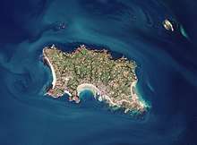
Jersey is the largest and southernmost of the Channel Islands. It is located north of Brittany and west of the Cotentin Peninsula in Normandy. About 30% of the population of the island is concentrated in Saint Helier, which is a parish and the capital town of the island.
Physical geography
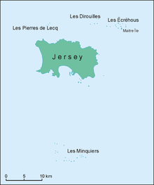
Besides the main island, the bailiwick includes other islets and reefs with no permanent population: Les Écréhous, Les Minquiers, Les Pierres de Lecq, Les Dirouilles.
The highest point in the island is Les Platons on the north coast, at 136 metres (446 ft). Parts of the parish of St Clement in the south were previously below sea-level but the construction of a seawall and infilling of low land has probably left only a few pockets of land below mean sea level. The terrain is generally low-lying on the south coast, with some rocky headlands, rising gradually to rugged cliffs along the north coast. On the west coast there are sand dunes. Small valleys run north to south across the island. Very large tidal variation exposes large expanses of sand and rock to the southeast at low tide.
Snow falls rarely in Jersey; some years will pass with no snow fall at all.

| Climate data for Jersey | |||||||||||||
|---|---|---|---|---|---|---|---|---|---|---|---|---|---|
| Month | Jan | Feb | Mar | Apr | May | Jun | Jul | Aug | Sep | Oct | Nov | Dec | Year |
| Average high °C (°F) | 8.3 (46.9) |
8.4 (47.1) |
10.4 (50.7) |
12.5 (54.5) |
15.8 (60.4) |
18.4 (65.1) |
20.4 (68.7) |
20.6 (69.1) |
18.7 (65.7) |
15.4 (59.7) |
11.7 (53.1) |
9.2 (48.6) |
14.2 (57.6) |
| Average low °C (°F) | 4.3 (39.7) |
3.8 (38.8) |
5.3 (41.5) |
6.5 (43.7) |
9.3 (48.7) |
11.8 (53.2) |
13.9 (57.0) |
14.3 (57.7) |
12.9 (55.2) |
10.6 (51.1) |
7.5 (45.5) |
5.0 (41.0) |
8.8 (47.8) |
| Average rainfall mm (inches) | 93.1 (3.67) |
68.9 (2.71) |
66.1 (2.60) |
56.4 (2.22) |
55.6 (2.19) |
47.5 (1.87) |
44.6 (1.76) |
49.5 (1.95) |
63.9 (2.52) |
103.4 (4.07) |
105.4 (4.15) |
111.3 (4.38) |
865.8 (34.09) |
| Average rainy days (≥ 1.0 mm) | 14.8 | 11.7 | 11.7 | 10.1 | 8.9 | 7.5 | 7.1 | 7.3 | 9.2 | 13.6 | 15.2 | 15.2 | 132.2 |
| Mean monthly sunshine hours | 66.1 | 91.6 | 134.0 | 196.5 | 236.7 | 245.4 | 252.7 | 235.3 | 184.6 | 118.8 | 79.9 | 63.2 | 1,904.8 |
| Source: Met Office[2] | |||||||||||||
Natural resources
The main natural resource on this island is arable land. 66% of the island's land is used as such, and the remaining 34% is used for other purposes.
Environment
Current environmental issues for Jersey include waste disposal, air pollution and traffic.
References
- 2011 census results
- "Jersey: Climate Period: 1981-2010". Met Office. Retrieved 5 February 2013.