Hron
The Hron (Slovak: Hron; German: Gran; Hungarian: Garam; Latin: Granus) is a 298-kilometre (185 mi) long left tributary of the Danube and the second-longest river in Slovakia. It flows from its source in the Low Tatra Mountains (below Kráľova hoľa) through central and southern Slovakia, emptying into the Danube near Štúrovo and Esztergom. Major cities and towns on the Hron are Brezno, Banská Bystrica, Sliač, Zvolen, Žiar nad Hronom, Žarnovica, Nová Baňa, Tlmače, Levice, Želiezovce, and Štúrovo.
| Hron | |
|---|---|
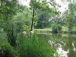 The Hron near Starý Tekov | |
 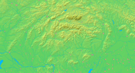 Current and watershed of the Hron River in Slovakia | |
| Location | |
| Country | Slovakia |
| Region | Banská Bystrica, Nitra |
| Physical characteristics | |
| Source | Hron |
| • location | Kráľova hoľa near Telgárt, Low Tatras, Banská Bystrica Region |
| • elevation | 980 m (3,220 ft) |
| Mouth | Danube River |
• location | Kamenica nad Hronom, Nitra Region |
• elevation | 112 m (367 ft) |
| Length | 298 km (185 mi) |
| Basin size | 5,453 km2 (2,105 sq mi) |
| Discharge | |
| • average | 53.7 m3/s (1,900 cu ft/s) |
| • minimum | 7.6 m3/s (270 cu ft/s) |
| • maximum | 1,050 m3/s (37,000 cu ft/s) |
| Basin features | |
| Tributaries | |
| • left | Slatina |
| Progression | Danube→ Black Sea |
The river's basin covers approximately 11 percent of Slovakia's territory.
Etymology
The name is probably of Germanic origin; *Granahua: gran – spruce, ahua – water.[1]
History
The name of the river was mentioned for the first time in 170, when Roman Emperor Marcus Aurelius wrote his Meditations at the Hron (Latin: Granus) river.[2] The first recorded medieval name was Gron (1075).[2] From the 17th century until the 1930s, the river was used for wood transport.
References
- Krško, Jaromír (2008). Hydronymia povodia Hrona (in Slovak). Banská Bystrica: Univerzita Mateja Bela. p. 81. ISBN 978-80-8083-611-5.
- Krško, Jaromír (June 2003). "Názvy potokov v Banskej Bystrici a okolí". Bystrický Permon. 1 (2): 8.
| Wikimedia Commons has media related to Hron. |
| Countries |  | |
|---|---|---|
| Cities | ||
| Tributaries | ||
| Canals | ||
| See also | ||
| Authority control |
|---|