Geography of the Czech Republic
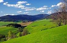
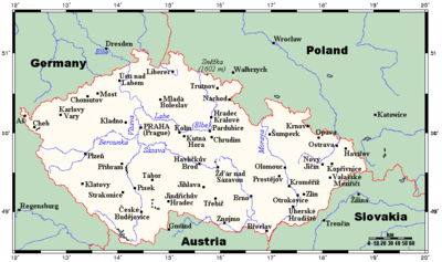
The geography of the Czech Republic is quite varied. Bohemia, at the west part of Czech Republic, consists of a river basin, drained by the Elbe (Czech: Labe) and Vltava rivers. It is surrounded by mostly low mountains such as the Sudetes with its part Krkonoše, containing the highest point in the country, the Sněžka at 1,603 metres (5,259 ft). Moravia, the eastern part, is also quite hilly and is drained predominantly by the Morava river, but also contains the source of the Oder (Czech: Odra) river. Water from the landlocked Czech Republic flows to three different seas: the North Sea, Baltic Sea and Black Sea. The Czech Republic also possesses Moldauhafen, a 30,000-square-metre (7.4-acre) enclave in the middle of Hamburg docks, which was awarded to Czechoslovakia by Article 363 of the Treaty of Versailles to allow the landlocked country a place where goods transported downriver could be transferred to seagoing ships; this territory reverts to Germany in 2028.
Statistics
Location:
Central Europe, southeast of Germany

Geographic coordinates: 49°45′N 15°30′E
Map references: Europe
Area:
- total: 78,867 km2 (30,451 sq mi)
- land: 77,247 km2 (29,825 sq mi)
- water: 1,620 km2 (630 sq mi)
Area – comparative: slightly smaller than South Carolina, USA; slightly larger than Scotland
Land boundaries:
- total: 2,290 km (1,423 mi)
- border countries: Austria 466 km (290 mi), Germany 810 km (503 mi),[1] Poland 762 km (473 mi), Slovakia 252 km (157 mi)
Panhandles:
Aš Hook, Šluknov Hook, Frýdlant Hook, Broumov Hook, Javorník Hook, Osoblaha Hook, Břeclav Hook (March-Thaya Triangle).
Coastline: 0 km (landlocked)
Maritime claims: none (landlocked)
Climate: temperate; hot summers; cold, cloudy, humid winters
Terrain: Bohemia in the west consists of rolling plains, hills, and plateaus surrounded by low mountains; Moravia in the east consists of very hilly country
Elevation extremes:
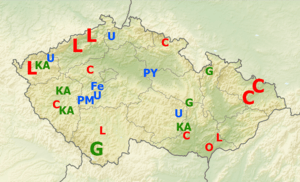
Natural resources: hard coal, soft coal, kaolin, clay, graphite, timber, uranium
Land use:
- arable land: 40.88%
- permanent crops: 0.98%
- other: 58.14% (2012 est.)
Irrigated land: 385.3 km2 or 148.8 sq mi0 (2007)
Total renewable water resources: 13.15 km3 (3 cu mi) (2011)
Freshwater withdrawal (domestic/industrial/agricultural):
- total: 1.7 km3/yr (41%/56%/2%)
- per capita: 164.7 m3/yr (2009)
Natural hazards: flooding
Environment – international agreements:
- party to: Air pollution, Air pollution-nitrogen oxides, Air Pollution-Persistent Organic Pollutants, Air Pollution-Sulfur 85, Air Pollution-Sulfur 94, Air Pollution-Volatile Organic Compounds, Antarctic-Environmental Protocol, Antarctic Treaty, Biodiversity, Climate Change-Kyoto Protocol, Endangered Species, Environmental Modification, Hazardous Wastes, Law of the Sea, Nuclear Test Ban, Ozone Layer Protection, Ship Pollution, Wetlands, Whaling
- signed, but not ratified: none
Geography – note: landlocked; strategically located astride some of oldest and most significant land routes in Europe; Moravian Gate is a traditional military corridor between the North European Plain and the Danube in central Europe
Important cities
Urbanisation
References
- "CIA – The World Factbook – Czech Republic". The World Factbook. Central Intelligence Agency. 31 May 2012. Retrieved 31 May 2012.
- "2011 census" (in Czech). Czech Statistical Office. Retrieved 1 January 2015.
![]()
Czech Republic articles | |||
|---|---|---|---|
| History |
|  | |
| Geography | |||
| Politics | |||
| Economy | |||
| Society | |||
| Culture | |||
| |||