Olt (river)
The Olt (Romanian and Hungarian; German: Alt; Latin: Aluta or Alutus, Turkish: Oltu, Ancient Greek: Ἄλυτος Alytos) is a river in Romania.[1][2] It is 615 km (382 mi) long, and its basin area is 24,050 km2 (9,290 sq mi).[2][3] It is the longest river flowing exclusively through Romania. Its source is in the Hășmaș Mountains of the eastern Carpathian Mountains, near Bălan, rising close to the headwaters of the river Mureș. It flows through the Romanian counties Harghita, Covasna, Brașov, Sibiu, Vâlcea and Olt. The river was known as Alutus or Aluta in Roman antiquity. Olt County and the historical province of Oltenia are named after the river.
| Olt | |
|---|---|
 The Avrig reservoir on the Olt | |
 | |
| Location | |
| Country | Romania |
| Counties | Harghita, Covasna, Brașov, Sibiu, Vâlcea, Olt, Teleorman |
| Cities | Sfântu Gheorghe, Râmnicu Vâlcea, Slatina |
| Physical characteristics | |
| Source | Hășmaș Mountains |
| ⁃ location | Bălan, Harghita |
| ⁃ elevation | 1,440 m (4,720 ft) |
| Mouth | Danube |
⁃ location | near Turnu Măgurele |
⁃ coordinates | 43°42′46″N 24°48′1″E |
| Length | 615 km (382 mi) |
| Basin size | 24,050 km2 (9,290 sq mi) |
| Discharge | |
| ⁃ location | * |
| ⁃ average | 190 m3/s (6,700 cu ft/s) |
| Basin features | |
| Progression | Danube→ Black Sea |
| Tributaries | |
| ⁃ left | Râul Negru, Bârsa, Topolog |
| ⁃ right | Cormoș, Cibin, Lotru, Olteț |
| River code | VIII.1 |
Sfântu Gheorghe, Râmnicu Vâlcea and Slatina are the main cities on the river Olt. The Olt flows into the Danube river near Turnu Măgurele.
Towns and villages
The following towns and villages are situated along the river Olt, from source to mouth (incomplete list): Bălan, Sândominic, Miercurea Ciuc, Sfântu Gheorghe, Făgăraș, Brezoi, Călimănești, Râmnicu Vâlcea, Drăgășani, Slatina, Drăgănești-Olt.
Tributaries
The following rivers are tributaries of the river Olt (from source to mouth):[2]
- Left: Mediaș, Fântâna lui Gal, Sedloco, Babașa, Șoarecu, Cad, Racul, Nicolești, Delnița, Pustnic, Fitod, Fișag, Tușnad, Vârghiș, Valea Roșie, Micfalău, Pârâul Urșilor, Malnaș, Hereț, Talomir, Râul Negru, Valea Neagră, Ghimbășel, Bârsa, Homorod (Ciucaș), Crizbav, Valea Cetății (Rotbav), Valea Seacă, Hotaru, Măieruș, Bozom, Valea Lungă, Remetea, Ormeniș, Top, Valea Cetății (Racoș), Valea Mare, Bogata, Lupșa, Comana, Veneția, Părău, Găvan, Șercaia, Urăsa, Mândra, Iaz, Sebeș, Racovița, Hurez, Săvăstreni, Netot, Dridif, Breaza, Sâmbăta, Racovița, Drăguș, Hotarul, Viștea, Corbul Viștei, Corbul Ucei, Ucea, Racovița, Gârlățel, Gostaia, Arpaș, Valea Neagră, Cârțișoara, Opat, Scorei, Sărata, Porumbacu, Avrig, Mârșa, Racovița, Sebeș, Strâmba, Rândibou, Curpăn, Valea Satului, Boia Mare, Pârâul Sec, Băiaș, Lotrișor, Văratica, Păușa, Valea Satului, Sălătrucel, Alunoasa, Valea Satului, Sâmnic, Aninoasa, Pârâul Ruzii, Topolog, Ursana, Stăneasa, Geamăna, Cungra, Sterpul, Cepturaru, Surduiu, Cungrișoara, Recea, Racovăț, Teslui, Strehareți, Milcov, Cinculeasa, Oboga, Dârjov, Iminog
- Right: Sipoș, Lunca Mare, Lunca, Modicea, Mădărașul Mare, Șopot, Var, Segheș, Știuca, Beta, Capolnaș, Techera, Valea Mare, Chendreș, Valea Merilor, Chereș, Pârâul Mare, Mitaci, Răchitiș, Calnic, Valea Crișului, Arcuș, Valea Porumbelor, Debren, Valea Sâmbrezii, Ilieni, Baciu, Vâlcele, Hăghig, Iarăș, Corlat, Belinul Mare, Valea Adânca, Aita, Valea Mateiașului, Pârâul Adânc, Căpeni (Chepeț), Baraolt, Cormoș, Pârâul Sărat, Homorod, Dăișoara, Crăița, Ticuș, Felmer, Galați, Poenița, Cincu, Golbav, Pârâul Nou, Valea Fermelor, Brad, Cibin, Pleașa, Megieș, Lotrioara, Vad, Valea Largă, Valea lui Vlad, Uria, Robești, Sărăcinești, Călinești, Lotru, Lotrișor, Căciulata, Valea Căldărilor, Muereasca, Bujoreanca, Olănești, Pârâul Sărat, Govora, Focșa, Bistrița, Luncavăț, Nisipoasa, Pesceana, Oporelu Canal, Oltișor, Olteț, Teslui, Caracal, Vlădila, Suhat, Crușov
Dams
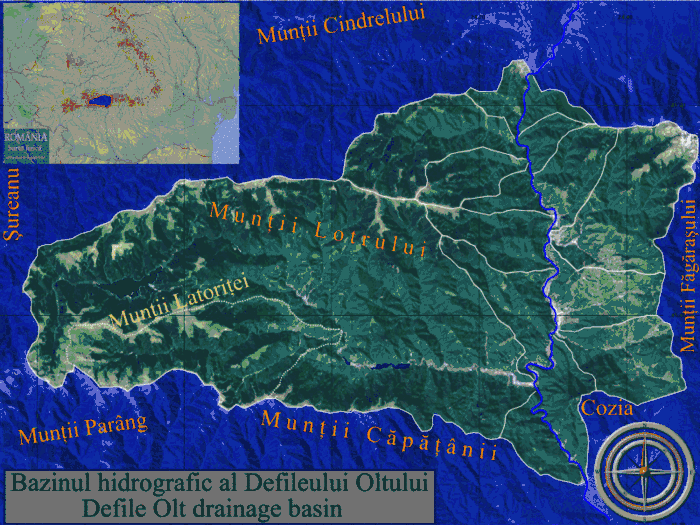
For supply of drinking water and water for irrigation and for the production of hydroelectricity, 44 reservoirs have been built in the Olt river basin. There are 24 reservoirs for hydropower on the river Olt itself, and three on its tributary Lotru.[4] There are hydropower plants at (from source to mouth) Voila, Viștea, Arpaș, Scoreiu, Avrig, Gura Lotrului, Turnu, Călimănești, Dăești, Râmnicu Vâlcea, Râureni, Govora, Băbeni, Ionești, Zăvideni, Drăgășani, Strejești, Arcești, Slatina, Ipotești, Drăgănești, Frunzaru, Rusănești and Izbiceni. The total energy production of the 43 hydropower plants in the Olt basin was 2,980 GWh in 1996.[5]
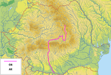
Clickable map of the (ro:Defileul Oltului)/(en:Olt Defile) drainage basin
Gallery
 Olt – Close to the source, at Siculeni
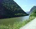 The Olt River at Turnu Roșu
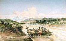
 Carol Popp de Szathmary, Olt Valley
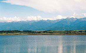
 Slatina storage reservoir on the Olt river
- More pictures: Raft ride (rafting) on Olt
See also
References
- "Planul național de management. Sinteza planurilor de management la nivel de bazine/spații hidrografice, anexa 7.1" (PDF, 5.1 MB). Administrația Națională Apele Române. 2010. pp. 635–638.
- Atlasul cadastrului apelor din România. Partea 1 (in Romanian). Bucharest: Ministerul Mediului. 1992. pp. 263–308. OCLC 895459847. River code: VIII.1
- Danube River Basin District, Part A - Roof Report, IPCDR, p 12
- Hydro-technical infrastructure in Romania, SEPIC, Bucharest (2004) pp. 23-27
- Danube Pollution Reduction Programme, National Reviews 1998 Romania, pp. 84-87 (of 262)
External links
| Wikimedia Commons has media related to Olt River. |
| Countries |  | |
|---|---|---|
| Cities | ||
| Tributaries | ||
| Canals | ||
| See also | ||
| Authority control |
|
|---|