Geography of Papua New Guinea
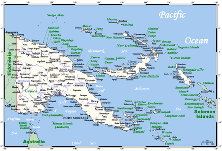
The geography of Papua New Guinea describes the eastern half of the island of New Guinea, the islands of New Ireland, New Britain and Bougainville, and smaller nearby islands. Together these make up the nation of Papua New Guinea in tropical Oceania, located in the western edge of the Pacific Ocean.
 | |
| Continent | Pacific Ocean |
|---|---|
| Region | Oceania |
| Coordinates | 6°00′S 147°00′E |
| Area | Ranked 54th |
| • Total | 462,840 km2 (178,700 sq mi) |
| • Land | 98% |
| • Water | 2% |
| Coastline | 5,152 km (3,201 mi) |
| Borders | 820 kilometres (510 mi) |
| Highest point | Mount Wilhelm 4,509 metres (14,793 ft) |
| Lowest point | Pacific Ocean 0 m |
| Exclusive economic zone | 2,402,288 km2 (927,529 sq mi) |
Papua New Guinea is largely mountainous, and much of it is covered with tropical rainforest. The New Guinea Highlands runs the length of New Guinea, and the highest areas receive snowfall—a rarity in the tropics. Within Papua New Guinea Mount Wilhelm is the highest peak, at 4,509 m (14,793 ft). There are several major rivers, notably the Sepik River, which is 1,126 km (700 mi) long, which winds through lowland swamp plains to the north coast, and the Fly River at 1,050 km (650 mi) in length, which flows through one of the largest swamplands in the world to the south coast. The Highlands consist of a number of smaller ranges running west to east, such as the Finisterre Range which dominates the Huon Peninsula to north of the city of Lae. At 462,840 km2 (178,700 sq mi) it is the world's 3rd largest island country.[1]
Papua New Guinea has one land border—that which divides the island of New Guinea. Across the 820 km (509 mi) border is the Papua province of Indonesia, which contains most of the western half of the island (West Papua was split off in 2003, and forms the remainder). Papua New Guinea's border with Indonesia is not straight; the border loops slightly to the west along the Fly River in the south-central part of New Guinea, on the western edge of Papua New Guinea's Western Province. There are maritime borders with Australia to the south and Solomon Islands to the southeast.
Physical geography
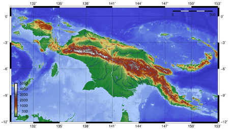
Papua New Guinea has a total area of 462,840 km2 (178,700 sq mi), of which 452,860 km2 (174,850 sq mi) is land and 9,980 km2 (3,850 sq mi) is water. This makes it the 3rd largest island country in the world.[1] Its coastline is 5 152 km long.
The northernmost point is Mussau Island (1°23' S), southernmost point is Hemenahei Island (11°29' S), easternmost point is Olava, Bougainville (155°57' E) and the westernmost point is either Bovakaka along the Fly River border with Indonesia or Mabudawan (140°54' E).
Papua New Guinea has several volcanoes, as it is situated along the Pacific Ring of Fire. Volcanic eruptions are not rare, and the area is prone to earthquakes and tsunamis because of this. The volcanic disturbance can often cause severe earthquakes, which in turn can also cause tsunamis. Papua New Guinea is also prone to landslides, often caused by deforestation in major forests. The mountainous regions of Papua New Guinea are the areas most susceptible to landslides causing damage.
Offshore islands include the small, forested Admiralty Islands, the largest of which is Manus, to the north of the main island of New Guinea. These have a distinct plant and animal life from the main island but the natural forest has been cleared in places for logging and agriculture.[2]
Rivers of PNG
Sepik
Fly
Purari
Climate
Tropical; northwest monsoon (December to March), southeast monsoon (May to October); slight seasonal temperature variation. In lower altitudes, the temperature is around 80 °F (27 °C) year round. But higher altitudes are a constant 70 °F (21 °C), and the highest altitudes, especially of Mount Wilhelm and Mount Giluwe, can see snow.[3]
Human geography
Maritime claims: These are measured from claimed archipelagic baselines.
- Continental shelf:
- 200-m depth or to the depth of exploitation
- Exclusive economic zone:
- 2,402,288 km2 (927,529 sq mi). 200 mi (320 km) nautical miles
- Territorial sea:
- 12 nautical miles (22 km)
Land use
Natural resources: gold, copper, silver, natural gas, timber, oil, fisheries
Land use:
- arable land: 0.49%
- permanent crops: 1.4%
- other (forests, swamplands, etc.): 98.11% (2005 estimate)
Environmental issues
The rainforest is subject to deforestation as a result of growing commercial demand for tropical timber; forest clearance, especially in coastal areas, for plantations; pollution from mining projects. If the trend continues, more than half the forest that existed when Papua New Guinea became independent from Australia in 1975 will be gone by 2021.[4]
Environment - international agreements
signed, but not ratified
- Antarctic-Environmental Protocol
signed and ratified
- Climate Change-Kyoto Protocol
Extreme points
Extreme points
- Northernmost point – Suf Island
- Northernmost point (mainland) – Sandaun Province
- Southernmost point – Vanatinai
- Southernmost point (mainland) – Near Suau, Samarai-Murua District
- Westernmost point – Border with Indonesia, Western Province
- Easternmost point – Nukumanu Islands, North Solomons
- Easternmost point (mainland) – Milne Bay
- Highest point – Mount Wilhelm: 4,509 m
- Lowest point – Pacific Ocean: 0 m
See also
References
- "Island Countries Of The World". WorldAtlas.com. Archived from the original on 2017-12-07. Retrieved 2019-08-10.
- "Admiralty Islands lowland rain forests". Terrestrial Ecoregions. World Wildlife Fund.
- https://openresearch-repository.anu.edu.au/bitstream/1885/132966/1/BG_04.pdf
- University of Papua New Guinea The State of the Forests in Papua New Guinea Archived 2008-07-19 at the Wayback Machine
- "CIA World Factbook". Retrieved 2006-05-25.
Papua New Guinea articles | |||||
|---|---|---|---|---|---|
| History |  | ||||
| Geography | |||||
| Politics | |||||
| Economy |
| ||||
| Society |
| ||||
| |||||