Geography of Samoa
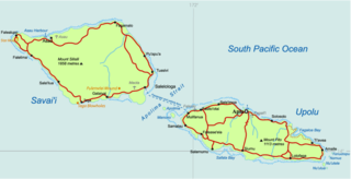
The country of Samoa consists of the two large islands of Upolu and Savai'i and eight smaller islands located about halfway between Hawaii and New Zealand in the Polynesian region of the South Pacific Ocean. The island of Upolu is home to nearly three-quarters of Samoa's population and its capital city of Apia. Samoa occupies an almost central position within Polynesia. The climate is tropical, with a rainy season from November to April. To the east is the smaller American Samoa.

Statistics
Location: Oceania
Geographic coordinates: 13°35′S 172°20′W
Area:
- total: 2,944 km2 (1,137 sq mi)
- land: 2,934 km2 (1,133 sq mi)
- water: 10 km2 (3.9 sq mi)
Area - comparative: slightly smaller than Rhode Island
Coastline: 403 km (250 mi)
Maritime claims:
- exclusive economic zone: 200 nautical miles (370 km; 230 mi)
- territorial sea: 12 nautical miles (22 km; 14 mi)

Elevation extremes:
- lowest point: Pacific Ocean 0 m (0 ft)
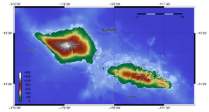
- highest point: Mauga Silisili 1,857 m (6,093 ft)
Land use:
- arable land: 21.2%
- permanent crops: 24.38%
- other: 54.42%
A natural hazard of the islands is active volcanism. Current environmental issues are soil erosion, deforestation, invasive species, and overfishing.
Environment - international agreements:
- party to: Biodiversity, Climate Change, Climate Change-Kyoto Protocol, Desertification, Hazardous Wastes, Law of the Sea, Ozone Layer Protection
Climate
Tropical; rainy season from November to April, dry season from May to October. Samoa encounters the occasional cyclone.
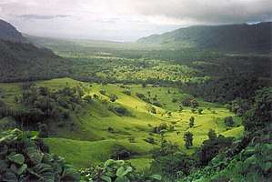
Terrain
Terrain consists of two main islands Savai'i and Upolu, with settlements on Manono and Apolima in the Apolima Strait between Savai'i and Upolu. A small uninhabited island Namua sits between Manono and Apolima. Off the east end of Upolu are the Aleipata Islands, small uninhabited islets; The terrain of the two main islands are narrow coastal plains with volcanic, rocky, rugged mountains in interior. Natural resources include hardwood forests, fish, and hydropower.
See also
- List of cities, towns and villages in Samoa
- Districts of Samoa
- Samoan Islands
- Geography of American Samoa

![]()