Fly River
The Fly, at 1,050 kilometres (650 mi), is the second longest river in Papua New Guinea, after the Sepik. By volume of discharge, the Fly is the largest river in Oceania, the largest in the world without a single dam in its catchment, and overall the 25th-largest primary river in the world.[2] It rises in the Victor Emanuel Range arm of the Star Mountains, and crosses the south-western lowlands before flowing into the Gulf of Papua in a large delta.
| Fly | |
|---|---|
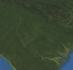 NASA Blue Marble satellite image of the Fly River | |
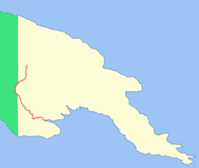 Location of the Fly | |
| Location | |
| Country | Papua New Guinea, Indonesia |
| Physical characteristics | |
| Source | |
| ⁃ location | Star Mountains, Papua New Guinea |
| Mouth | |
⁃ location | Gulf of Papua, Papua New Guinea |
| Length | 1,050 km (650 mi) |
| Basin size | 76,000 km2 (29,000 sq mi)[1] |
| Discharge | |
| ⁃ average | 6,000 m3/s (210,000 cu ft/s) |
| Basin features | |
| Tributaries | |
| ⁃ left | Strickland River |
| ⁃ right | Ok Tedi River |
Description
The Fly flows mostly through the Western Province, though for a small stretch it forms the boundary between Papua New Guinea and the Indonesian province of Papua. This section protrudes slightly to the west of the 141°E longitude line.[3] To compensate for this slight gain in territory for Papua New Guinea, the border south of the Fly River is slightly east of the 141°E longitude line. As part of this deal, Indonesia has the right to use the Fly River to its mouth for navigation.
The principal tributaries of the Fly are the Strickland and the Ok Tedi.
Close to its mouth, the flow of the Fly River encounters a tidal bore, where an incoming high tide pushes water upstream until the tide changes. The range of this tidal bore is still undocumented.[4]
Delta
The delta of the Fly River is over 100 km wide at its entrance, but only 11 km wide at the apex upstream of Kiwai Island. The delta contains 3 main distributary channels (the Southern, Northern, and Far Northern Entrances) that branch from a common point (the “apex”). The distributary channels are 5 to 15m in depth, separated by elongate, sand-mud islands that are stabilised by lush mangrove vegetation. The islands are eroded and rebuilt rapidly in the apex area, where they have lateral migration rates of up to 150 m/a, with slower rates for the more seaward islands. Upstream from the apex the river gradually narrows to a width of 1.6 km or less. The Fly Delta exhibits a distinctive funnel shape in plan view, attesting to the fundamental role of tidal currents in shaping the Delta's geomorphology. Mean spring tidal ranges are amplified within the delta, from around 3.5m at the seaward entrance of the distributary channels, reaching a peak of about 5m at the delta apex.[5] Seismic profiles and radiometrically dated core samples indicate that the delta is prograding seawards at an average rate of about 6 m/a [6] The Fly Delta is considered as a global "type case" of a tide-dominated delta and the patterns of sedimentation seen in the Delta today have been studied by sedimentary geologists as a model for interpreting the ancient rock record [7]
The river delta is studded with low and swampy islands covered with mangrove and nipa palm, with villages and cultivated areas on these islands. The land on both sides of the estuary is of the same character. The islands in the estuary are flat and covered with thick, fertile alluvial soil. The largest islands are Kiwai Island, Purutu Island, Wabuda Island, Aibinio Island, Mibu Island, and Domori Island. Kiwai, Wabuda and Domori are inhabited.
A list of the river delta islands is:
|
|
|
The inhabitants of the Fly River delta engage in agriculture and hunting. Coconut palm, breadfruit, plantain, sago palm, and sugar cane are grown.
History
The Fly was first discovered by Europeans in 1845 when Francis Blackwood, commanding the corvette HMS Fly, surveyed the western coast of the Gulf of Papua.[8] The river was named after his ship and he proclaimed that it would be possible for a small steam-powered boat to travel up the mighty river.[9]
In 1876, Italian explorer, Luigi D'Albertis, was the first person to successfully attempt this when he travelled 900 km into the interior of New Guinea, in his steamer, Neva. It was the furthest any European explorer had ever been into the island.[9]
Environmental issues
Both the Strickland and the Ok Tedi Rivers have been the source of environmental controversy due to tailings waste from the Porgera Mine and the Ok Tedi Mine, respectively. Sediment sampling and coring in the distributary channels of the Fly Delta had not detected copper concentrations significantly higher than background as of 1994.[10] In 2008, Dr Ian Campbell, a former advisor to Ok Tedi Mining Limited, claimed that company data suggest significant portions of the Fly River floodplain are at a high risk from acid mine drainage.[11]
See also
References
- IUCN: The Fly River Catchment - A Regional Environmental Assessment, 1995
- "Fragmentation and Flow Regulation of the World's Major River Systems" (PDF). Archived from the original (PDF) on 2012-03-30. Retrieved 2011-08-17.
- Frank Jacobs (March 13, 2012). "Who Bit My Border?". The New York Times.
- p.159, Barrie R. Bolton. 2009. The Fly River, Papua New Guinea: Environmental Studies in an Impacted Tropical River System. Elsevier Science. ISBN 978-0444529640.
- Harris, P.T., Baker, E.K., Cole, A.R., Short, S.A., 1993. A preliminary study of sedimentation in the tidally dominated Fly River Delta, Gulf of Papua. Continental Shelf Research 13, 441-472.
- Harris, P.T., Hughes, M.G., Baker, E.K., Dalrymple, R.W., Keene, J.B., 2004. Sediment transport in distributary channels and its export to the pro-deltaic environment in a tidally-dominated delta: Fly River, Papua New Guinea. Continental Shelf Research 24, 2431-2454.
- Dalrymple, R. W., E. K. Baker, P. T. Harris and M. G. Hughes (2003). Sedimentology and stratigraphy of a tide-dominated, foreland-basin delta (Fly River, Papua New Guinea). Tropical Deltas of Southeast Asia and Vicinity - Sedimentology, Stratigraphy, and Petroleum Geology. F. H. Sidi, H. W. Posamentier, H. Darman, D. Nummedal and P. Imbert. Tulsa, Oklahoma, SEPM Special Publication 76. 76: 147–173.
- "Blackwood, Francis Price (1809 - 1854)". Australian Dictionary of Biography.
- Lightbody, Mark; Wheeler, Tony (1985). Papua New Guinea: a travel survival guide (3 ed.). Lonely Planet. p. 172. ISBN 0-908086-59-8.
- Harris, P.T., 2001. Environmental Management of Torres Strait: a Marine Geologist’s Perspective, in: Gostin, V.A. (Ed.), Gondwana to Greenhouse: environmental geoscience - an Australian perspective. Geological Society of Australia Special Publication, Adelaide, pp. 317-328.
- "PNG warned of environmental mining disaster". ABC News. Australian Broadcasting Corporation. 2008-09-06. Retrieved 2008-01-06.