Geography of New South Wales
New South Wales (abbreviated as NSW) is Australia's most populous state, located in the east coast of the continent. It is in the southern hemisphere between latitudes 28 and 38 degrees south of the equator and longitudes 143 and 154 degrees east of the Universal Prime Meridian (formerly known as the Greenwich meridian). The state is in the warm temperate climatic zone.
 | |
| Continent | Australia |
|---|---|
| Coordinates | 32°S 147°E |
| Area | Ranked 3rd among states and territories |
| • Total | 809,444 km2 (312,528 sq mi) |
| Coastline | 2,137 km (1,328 mi) |
| Borders | Land borders: Queensland, South Australia, Victoria |
| Highest point | Mount Kosciuszko 2,228 metres (7,310 ft) |
| Longest river | Murray River 1,721 kilometres (1,069 mi) |
| Largest lake | Lake Eucumbene 4,798 square kilometres (1,853 sq mi) |
Features
The area of New South Wales is 809,444 km2 (312,528 sq mi).[1] The coastline is 2,137 km (1,328 mi) in length.[2]
Cape Byron, in the north-east of the state, is Australia's most easterly mainland point.
The state is bordered on the north by Queensland, on the west by South Australia, and on the south by Victoria. Its coast faces the Tasman Sea. New South Wales contains two Federal enclaves: the Australian Capital Territory (ACT), and the Jervis Bay Territory.
New South Wales can be divided physically into four sections:
- A thin coastal strip, with climates warming from cool temperate on the far south coast to subtropical near the Queensland border, including the regions south of Sydney such as the Illawarra and Shoalhaven near Nowra. North of Sydney are the Central Coast and Newcastle, Hunter Region, Mid North Coast and Northern Rivers regions.
- The mountainous areas of the Great Dividing Range and the high country surrounding them. Whilst not particularly steep, many peaks rise above 1,000 m, with the highest Mount Kosciuszko at 2,229 m (7,308 ft). This includes the Southern Highlands, Central Tablelands and the Northern Tablelands.
- The agricultural plains that fill a significant portion of the state's area, with a much sparser population than the coast, including The Riverina area around Wagga Wagga.
- The Western Plains covering almost two-thirds of the state. In some years production is limited by water availability.
The steep escarpment of the Blue Mountains to the west of Sydney prevented European exploration beyond the coastal strip for several years until explorer Gregory Blaxland found a way through in 1813, 25 years after the first settlement in Sydney.
Cities and towns
Its four main cities from north to south are Newcastle, Gosford, Sydney, and Wollongong which all lie along the coast. Other cities and towns include Albury, Broken Hill, Dubbo, Tamworth, Armidale, Lismore, Nowra, Griffith, Leeton, Wagga Wagga, Goulburn, Port Macquarie and Coffs Harbour.
Gallery
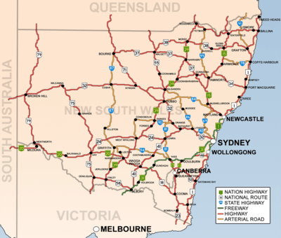 New South Wales showing highways connecting towns and major centres.
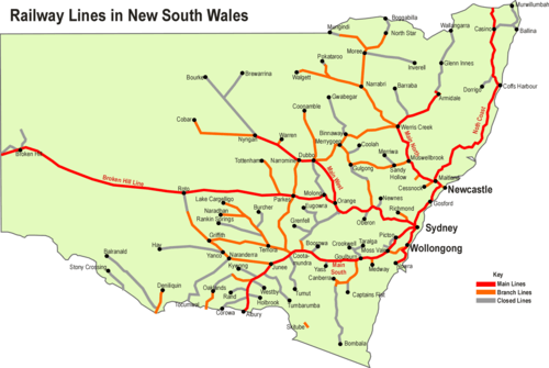 New South Wales showing railways connecting towns and major centres.
References
- "Area of Australia, States, and Territories". Geoscience Australia. 2005-08-31. Archived from the original on 2010-07-02. Retrieved 2010-06-19.
- "Coastline Lengths". Geoscience Australia. 2003-08-07. Archived from the original on 2009-06-18. Retrieved 2010-06-19.