Geography of Myanmar
Myanmar (also known as Burma) is the northwestern-most country of mainland Southeast Asia. It lies along the Indian and Eurasian Plates, to the southeast of the Himalayas. To its west is the Bay of Bengal and to its south is the Andaman Sea. It is strategically located near major Indian Ocean shipping lanes. The neighboring countries are China, India, Bangladesh, Thailand and Laos.
 | |
| Continent | Asia |
|---|---|
| Region | Southeast Asia |
| Coordinates | 22°00′N 98°00′E |
| Area | Ranked 40th |
| • Total | 676,578 km2 (261,228 sq mi) |
| • Land | 96.94% |
| • Water | 3.06% |
| Coastline | 1,930 km (1,200 mi) |
| Borders | Total land borders: 6,522 km (4,053 mi) Bangladesh: 271 km (168 mi) People's Republic of China: 2,129 km (1,323 mi) India: 1,468 km (912 mi) Laos 238 km (148 mi) Thailand: 2,416 km (1,501 mi) |
| Highest point | Hkakabo Razi 5881 m (19,294.62 ft) |
| Lowest point | Andaman Sea 0 m (0 ft) (sea level) |
| Longest river | Ayeyarwady River |
| Largest lake | Indawgyi Lake |
| Exclusive economic zone | 532,775 km2 (205,706 sq mi) |
Boundaries
Boundaries
Total Land Border Length: 6,522 kilometres (4,053 mi)[1]
Total Land Area: 676,578 square kilometres (261,228 sq mi)
Border Countries:
Bangladesh: 271 kilometres (168 mi), India:1,468 kilometres (912 mi), China: 2,129 kilometres (1,323 mi), Laos: 238 kilometres (148 mi), Thailand: 2,416 kilometres (1,501 mi)
Coastline
Total coastline length:2,228 kilometres (1,384 mi)
Total water area: 23,070 square kilometres (8,910 sq mi)
Climate
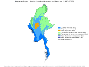
Tropical monsoon in the lowlands below 1,000 m (3,281 ft); cloudy, rainy, hot, humid summers (southwest monsoon, June to September); less cloudy, scant rainfall, mild temperatures, lower humidity during winter (northeast monsoon, December to April).
Climate varies in the highlands depending on elevation; subtropical temperate climate at around 2,500 m (8,202 ft), temperate at 3,000 m (9,843 ft), cool, alpine at 3,500 m (11,483 ft) and above the alpine zone, cold, harsh tundra and Arctic climate. The higher elevations are subject to heavy snowfall, especially in the north.
Mountains
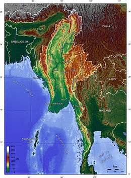
Myanmar is characterised by its central lowlands with the Sittaung Valley and Chindwin Valley and the small mountain ranges of Zeebyu Taungdan, Min-wun Taungdan, Hman-kin Taungdan and Gangaw Taungdan as well as the Bago Yoma (Pegu Range), a relatively low mountain chain between the Irrawaddy and the Sittaung River in central Myanmar.[2] The Central Valley Region is limited by steep, rugged highlands in the North, where ranges at the southern end of the Hengduan System form the border between Myanmar and China. Hkakabo Razi, the country's highest point at 5,881 m (19,295 ft), is located at the northern end of the country. This mountain is part of a series of parallel ranges that run from the foothills of the Himalaya through the border areas with Assam, Nagaland and Mizoram.
The Arakan Mountains in the west run from Manipur into western Myanmar southwards through Rakhine State almost to Cape Negrais in the shores of the Bay of Bengal. The Arakan Range includes the Naga Hills, the Chin Hills, and the Patkai range which includes the Lushai Hills.[3]
In eastern Myanmar the highest point of the Shan Hills is 2,563 m high Loi Pangnao, one of the ultra prominent peaks of Southeast Asia.[4][5] The Shan Hills form, together with the Karen Hills, Dawna Range and Tenasserim Hills, a natural border with Thailand as well as the Kayah-Karen/Tenasserim moist forests ecoregion[6] which is included in the Global 200 list of ecoregions identified by the World Wildlife Fund (WWF) as priorities for conservation.[7] Southern Myanmar consists largely of the western slopes of the Bilauktaung, the highest part of the Tenasserim Range, which extends southwards forming the central range of the Malay Peninsula.[8]
Main peaks
|
|
Rivers
The Irrawaddy, the main river of Burma, flows from north to south through the Central Burma Basin and ends in a wide delta. The Mekong river runs from the Tibetan Plateau through China's Yunnan province and northeastern Burma into Laos.
In the east the Salween and the Sittaung River run along the western side of the Shan Hills and the northern end of the Dawna Range. In the narrow southeastern part of Burma, the Ye, Heinze, Dawei (Tavoy), Great Tenasserim (Tanintharyi) and the Lenya rivers are relatively short and flow into the Andaman Sea. Further south the Kraburi River forms the southern border between Thailand and Burma.[9]
Maritime claims
Myanmar has the 50th largest exclusive economic zone of 532,775 km2 (205,706 sq mi). It includes more than 16 islands and the Mergui Archipelago.
Contiguous zone:
24 nmi (27.6 mi; 44.4 km)
Continental shelf:
200 nmi (230.2 mi; 370.4 km) or to the edge of the continental margin
Exclusive economic zone:
532,775 km2 (205,706 sq mi), 200 nmi (230.2 mi; 370.4 km)
Islands
- Apaw-ye Kyun
- Calventuras Islands
- Cheduba Island
- Coco Islands
- Kaingthaung Island
- Kalegauk Island
- Kokunye Kyun
- Kyungyi Island
- Moscos Islands
- Myingun Island
- Nantha Kyun
- Preparis
- Ramree Island
- Unguan
- Wa Kyun
- Zalat Taung
- Mergui Archipelago
- Auriol Island
- Bentinck Kyun
- Christie Island, the southernmost island of the group
- Kadan Kyun, the largest island of the archipelago
- Lanbi Kyun
- Letsok-aw Kyun
- Mali Kyun, the northernmost island of the group
- Saganthit Kyun
- Than Kyun
- Thayawthadangyi
- Zadetkyi
Land use and natural resources
Natural resources in Myanmar are petroleum, timber, tin, antimony, zinc, copper, tungsten, lead, coal, marble, limestone, precious stones, natural gas, and hydropower.
| Arable land | 16.56% |
|---|---|
| Permanent crops | 2.25% |
| Other land | 81.20% (2012) |
| Irrigated land | 21,100 km² (2004) |
| Total renewable water resources: | 1,168 km3 (280 cu mi) (2011) |
| Freshwater withdrawal, total (domestic/industrial/agricultural) | 33.23 km3/a (7.97 cu mi/a) (10%/1%/89%) |
| Freshwater withdrawal, per capita | 728.6 km3/a (175 cu mi/a) (2005) |
Natural hazards
Natural hazards include destructive earthquakes and cyclones. Flooding and landslides are common during the rainy season from June to September. Periodic droughts also occur. The most damaging cyclone that hit Myanmar was the Cyclone Nargis in 2008; with ongoing climate change oceans become warmer that may lead to cyclones becoming more intense and devastating for Myanmar.[10]
Environment
Environmental issues include deforestation; industrial pollution of air, soil, and water; inadequate sanitation and water treatment that contributes to disease.
Environment - international agreements
party to: Biodiversity, Desertification, Endangered Species, Law of the Sea, Nuclear Test Ban, Ozone Layer Protection, Ship Pollution, Tropical Timber 83, Tropical Timber 94
See also
References
- "The World Factbook — Central Intelligence Agency". www.cia.gov. Retrieved 3 April 2018.
- Myanmar in brief
- "Rakhine Mountains" Encyclopædia Britannica
- "Loi Pangnao (mountain) - Region: Shan State, Myanmar". Archived from the original on 23 April 2012. Retrieved 29 December 2011.
- Peaklist - Burma and Eastern India
- Kayah Karen Tenasserim Ecoregion Archived 26 March 2011 at the Wayback Machine
- "Tenasserim-South Thailand semi-evergreen rain forests". Terrestrial Ecoregions. World Wildlife Fund.
- An Introduction to Burma (Myanmar)
- Avijit Gupta, The Physical Geography of Southeast Asia, Oxford University Press, 2005. ISBN 978-0-19-924802-5
- Stokke, Kristian; Vakulchuk, Roman and Indra Overland (2018) Myanmar: A Political Economy Analysis. Norwegian Institute of International Affairs (NUPI). Report commissioned by the Norwegian Ministry of Foreign Affairs.
![]()
External links
- Myanmar Marine Biodiversity Atlas Online
- Ramsar - Burma
- Burma - Geography
- The Geology of Burma (Myanmar)
| Sovereign states |
|
|---|---|
| States with limited recognition | |
| Dependencies and other territories |
|
| |
| Sovereign states |
|
|---|---|
| States with limited recognition |
|
| Dependencies and other territories |
|
| |