Nat Ma Taung
Nat Ma Taung (Burmese: နတ်မတောင်; also known as Mount Victoria and Khaw-nu-soum or Khonuamthung in Chin), is the highest mountain in the Chin State of western Burma.[2] Located in 3 Townships - Kanpatlet, Mindat and Matupi, Mount Victoria is part of the Chin Hills range. The park is administered by the Department of Forestry and Environment.
| Nat Ma Taung | |
|---|---|
| Khaw-nu-soum / Mount Victoria | |
 Nat Ma Taung/Mount Victoria | |
| Highest point | |
| Elevation | 3,070 m (10,070 ft) [1] |
| Prominence | 2,148 m (7,047 ft) [1] |
| Listing | List of Ultras of Southeast Asia |
| Coordinates | 21°14′02″N 93°54′09″E |
| Geography | |
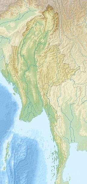 Nat Ma Taung Location in Burma | |
| Location | Chin State, Burma |
| Parent range | Chin Hills |
| Climbing | |
| First ascent | unknown |
| Easiest route | climb |
With a height of 3,053 metres (10,016 ft) above sea level and a prominence of 2,231 metres (7,320 ft), Nat Ma Taung is one of the ultra prominent peaks of Southeast Asia.[3] The White-browed nuthatch (Sitta victoriae) is a bird endemic to this mountain range.
Ecology
Nat Ma Taung is in the Chin Hills-Arakan Yoma montane forests ecoregion. Surrounded at lower elevations by tropical and subtropical moist forests, Nat Ma Taung's higher elevations form a sky island, home to many temperate and alpine species typical of the Himalaya further north, and many endemic species.
The mountain is now protected within Nat Ma Taung National Park (နတ်မတောင်အမျိုးသားဥယျာဉ်), established in 1994.[4]
The base of this national park can be reached either via Kanpetlet Township (easy access), or via Mindat Township (not easy as the road is incomplete). The only public transport to the base of the mountain is a four-wheel drive jeep that plies between Soe and the mountain base via Kanpetlet in the dry season. The road up to the lodge after Kanpetlet town is sealed (= hard-surfaced) and beyond is an earth track. The track is not navigable even by a four-wheel drive in the wet season due to severe damage by storm water. The track is the main access to about 20 villages near the base of the mountain. At the base of the mountain, one track leads to villages, the centre track leads to the peak, and the other tracktraverses to Mindat Township and then on to Soe Township. Due to tract damage, tourists, many national and few international, visit the mountain mainly in the dry season. The tract is navigable by a four-wheel drive car all the way to the peak. Lots of "taxi" motorcycles offer rides to the top, and if you walk both up and down, you are the extreme tourist. To walk from "base camp parking lot" it usually takes 3 hour up and maybe 2 down.
The peak is unique for the presence of trees, bushes and grass, which have adapted to the environment. On the way towards the top you will pass pine trees (Pinus kesiya), common names are Khasi pine, Benguet pine or three-needled pine. The Local name is ထင်းရှူး [tʰḭ́ jú]) which is one of the most widely distributed pines in Asia. as well as many oaks (Quercus spp.). Epiphytes still cover older trees despite illegal picking; so many Coelogyne, Dendrobium and Cymbidium plants can be seen. Rhododendron arboreum flowers along roads during the dry season.
The mountain is "protected" by words only. Many activities that hinder the natural beauty and its bio-diversity are taking place unabated. The park is virtually not managed, as there are no security personnel, park wardens and the like. One main threat that is affecting the bio-diversity of this national park is bush fires ignited by local people. Trees were seen burning even on top of the mountain in 2014 May. The second issue tarnishing the beauty of the mountain is accumulation of litter, paper, cartons, cans, plastic, polythene and cans. The visitors are not provided with any instructions on what not to do within the park. There is no admission fee. The number of visitors to the peak is unknown. Foreign visitors during the year are about 100 whereas large number of local people visit the peak almost daily in the dry season.
The people living in all villages are poor. Basic services such as education, health and water supply are extremely poor. There are opportunities that could provide potential employment to local people especially the youth through promotion of eco-tourism. The engagement of youth as tourist guides will also help protect this beautiful mountain by educating the public as well as making them to be vigilant over destructive activities that are taking place at present. The development of eco-tourism is also seen as a potential vehicle to develop remote villages hugged within the park.
Climate (Unsourced)
The mountaintop has a borderline alpine climate (Köppen climate classification ET) along with Subtropical Highland climate (Köppen Cwc/Cwb) in the nearby surroundings terrain.
| Climate data for Nat Ma Taung (Mount Victoria) Summit (3053m; 10070ft) | |||||||||||||
|---|---|---|---|---|---|---|---|---|---|---|---|---|---|
| Month | Jan | Feb | Mar | Apr | May | Jun | Jul | Aug | Sep | Oct | Nov | Dec | Year |
| Record high °C (°F) | 16.4 (61.5) |
19.6 (67.3) |
23.2 (73.8) |
26.4 (79.5) |
25.4 (77.7) |
22.5 (72.5) |
22.4 (72.3) |
20.5 (68.9) |
20.1 (68.2) |
19.8 (67.6) |
17.5 (63.5) |
15.6 (60.1) |
26.4 (79.5) |
| Average high °C (°F) | 7.8 (46.0) |
13.8 (56.8) |
16.7 (62.1) |
20.2 (68.4) |
18.4 (65.1) |
17.7 (63.9) |
17.7 (63.9) |
17.7 (63.9) |
15.3 (59.5) |
14.9 (58.8) |
13.2 (55.8) |
9.7 (49.5) |
15.3 (59.5) |
| Average low °C (°F) | −2.4 (27.7) |
3.3 (37.9) |
7.5 (45.5) |
9.5 (49.1) |
8.7 (47.7) |
8.6 (47.5) |
8.6 (47.5) |
8.1 (46.6) |
7.2 (45.0) |
5.5 (41.9) |
1.2 (34.2) |
−1.7 (28.9) |
5.3 (41.6) |
| Record low °C (°F) | −13.6 (7.5) |
−7.8 (18.0) |
−3.4 (25.9) |
−1.9 (28.6) |
2.3 (36.1) |
3.5 (38.3) |
4.7 (40.5) |
4.6 (40.3) |
2.4 (36.3) |
0.8 (33.4) |
−6.5 (20.3) |
−12.9 (8.8) |
−13.6 (7.5) |
| Average precipitation mm (inches) | 14.8 (0.58) |
7.7 (0.30) |
23.4 (0.92) |
67.9 (2.67) |
105.6 (4.16) |
178.7 (7.04) |
223.4 (8.80) |
209.2 (8.24) |
338.0 (13.31) |
201.2 (7.92) |
79.8 (3.14) |
20.4 (0.80) |
1,470.1 (57.88) |
Gallery
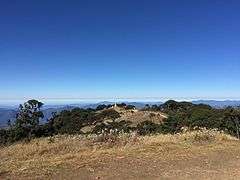 View from Nat Ma Taung's summit
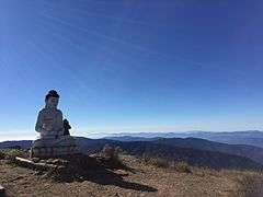 View from Nat Ma Taung's summit
 Morning view with travelers from Nat Ma Taung
See also
- List of Ultras of Southeast Asia
- List of mountains in Burma
- List of Southeast Asian mountains
References
- Peaklist - 19 Mountain Summits with Prominence of 1,500 meters or greater Retrieved 23 December 2013
- Kyaw Paing (2006) "22-Member Mountaineering Team Conquers Mt. Victoria in Chin State (1999)" Archived 2011-10-07 at the Wayback Machine Yangon University Hiking and Mountaineering Association, accessed 14 June 2009
- Peakbagger Mount Victoria, Myanmar
- Wikramanayake, Eric; Eric Dinerstein; Colby J. Loucks; et al. (2002). Terrestrial Ecoregions of the Indo-Pacific: a Conservation Assessment. Island Press; Washington, DC
External links
| Wikimedia Commons has media related to Nat Ma Taung. |