Gabès
Gabès (/ˈɡɑːbɛs/,[2][3] also UK: /ˈɡɑːbɪs/;[4] Tunisian Arabic: قابس, romanized: ![]()
Gabès قابس | |
|---|---|
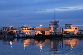 View of Gabès bay | |
 Gabès | |
| Coordinates: 33°53′N 10°07′E | |
| Country | |
| Governorates | Gabès |
| Population | |
| • Total | 374 300. [1] |
| Time zone | UTC+1 (CET) |
| • Summer (DST) | UTC+2 (CEST) |
| Website | Official website |
History
Etymology
Takapes, the ancient name of Gabès, is a Numidian (Berber) toponym. Later, the prefix "Ta" (meaning "to" in Berber) was dropped, and the place became known as Kapes. As in Arabic the sound /p/ is unknown, Kapes became known as Kabes, and later known as Gabès.
Roman period
Gabès is the ancient Tacapae[5][6] or Tacape (Τακάπη in Ancient greek) or Tacapes[7] of the Roman province of Tripolitania.
Strabo refers to this city as an important entrepot of the Lesser Syrtis. Pliny (18.22) remarks that the waters of a copious fountain at Tacape were divided among the cultivators according to a system where each had the use of the water during a certain interval of time.
The Tabula Peutingeriana shows Tacape between Marcomades and Sabratha.
Bishopric
Tacapae became a Christian bishopric that, no longer being a residential see, is included in the Catholic Church's list of titular sees.[8]
Three of its bishops are known:[9]
After the Roman and Christian period

- 7th century: The Umayyad Caliphate conquest. Muhammed's companion Sidi Abou Loobaba Al'Ansarey settles in Gabès.
- 1574: Gabès becomes part of the Eyalet of Tunis after the Ottoman conquest.
- 1881: Gabès comes under a French protectorate.
- 1940: Following the Fall of France, Gabès comes under German control.
- 1941: Gabès pogrom
- 1943: Gabès returns to French control with the help of the British (in the Mareth Line). The operation results in serious damage to the city infrastructure and in the defeat of Hitler for the first time in history.[10]
- 1945: The rebuilding of Gabès starts.
- 1956: Gabès reverts to Tunisian control with the independence of Tunisia from the French.
Education
- University of Gabès (science university, engineering school...)
Economy
Gabès is one of the biggest industrial cities in Tunisia. Most industries are chemical oriented, this is why the city offers one of the best chemistry degrees in Africa from the University of Gabès. The main industries are:
- Cement
- Chemical products
- Brick Factories
- Oil refinery
The fast-growing numbers of factories has resulted in fairly serious pollution of the area and of the Gulf of Gabès. In recent years the government is working on new programs and laws to decrease the amount of pollution.
Transport
Gabès – Matmata International Airport is in the city.
Gabès will soon be upgraded with one light rail system under the number 7 that will run from the railway station to the port of Gabès. Featuring rolling stock made by Alstom, Gabès will receive 15 new train sets.
Railways
Gabès is terminus of a narrow gauge 1,000 mm (3 ft 3 3⁄8 in) branch railway from the capital, and is the nearest railway station to the Libyan border at Ras Ajdir. Gabès has also one of the biggest ports in Tunisia; it is used usually to ship the mineral products from the city of Gafsa.
Roads
Gabès will be linked soon with the national motorway A1 (Tunis – Ras Ajdir)
Climate
Gabès has a hot semi-arid climate (Köppen climate classification BSh), characterized by a hot and dry season and a cool and arid season.
Climate
| Climate data for Gabès (1981–2010, extremes 1950–2014) | |||||||||||||
|---|---|---|---|---|---|---|---|---|---|---|---|---|---|
| Month | Jan | Feb | Mar | Apr | May | Jun | Jul | Aug | Sep | Oct | Nov | Dec | Year |
| Record high °C (°F) | 29.3 (84.7) |
33.9 (93.0) |
41.0 (105.8) |
38.2 (100.8) |
43.6 (110.5) |
46.5 (115.7) |
46.3 (115.3) |
46.6 (115.9) |
44.2 (111.6) |
40.1 (104.2) |
35.0 (95.0) |
31.2 (88.2) |
46.6 (115.9) |
| Average high °C (°F) | 16.9 (62.4) |
18.4 (65.1) |
20.2 (68.4) |
22.5 (72.5) |
25.4 (77.7) |
28.3 (82.9) |
31.3 (88.3) |
32.2 (90.0) |
30.3 (86.5) |
27.3 (81.1) |
22.5 (72.5) |
18.1 (64.6) |
24.5 (76.0) |
| Daily mean °C (°F) | 12.1 (53.8) |
13.3 (55.9) |
15.6 (60.1) |
18.2 (64.8) |
21.6 (70.9) |
24.9 (76.8) |
27.6 (81.7) |
28.5 (83.3) |
26.6 (79.9) |
23.1 (73.6) |
17.7 (63.9) |
13.4 (56.1) |
20.2 (68.4) |
| Average low °C (°F) | 7.8 (46.0) |
8.6 (47.5) |
11.2 (52.2) |
14.2 (57.6) |
17.9 (64.2) |
21.5 (70.7) |
23.7 (74.7) |
24.7 (76.5) |
22.8 (73.0) |
18.9 (66.0) |
13.3 (55.9) |
9.2 (48.6) |
16.2 (61.1) |
| Record low °C (°F) | −2.7 (27.1) |
−2.0 (28.4) |
0.9 (33.6) |
4.6 (40.3) |
8.2 (46.8) |
12.0 (53.6) |
15.6 (60.1) |
16.8 (62.2) |
14.4 (57.9) |
6.8 (44.2) |
2.6 (36.7) |
0.0 (32.0) |
−2.7 (27.1) |
| Average precipitation mm (inches) | 26.3 (1.04) |
11.3 (0.44) |
15.6 (0.61) |
15.8 (0.62) |
9.1 (0.36) |
2.1 (0.08) |
0.3 (0.01) |
1.2 (0.05) |
23.8 (0.94) |
31.4 (1.24) |
23.3 (0.92) |
27.9 (1.10) |
188.1 (7.41) |
| Average precipitation days (≥ 1.0 mm) | 2.8 | 2.4 | 2.8 | 2.4 | 1.1 | 0.6 | 0.1 | 0.2 | 1.6 | 3.4 | 2.7 | 3.1 | 23.2 |
| Average relative humidity (%) | 62 | 59 | 62 | 63 | 65 | 66 | 63 | 65 | 66 | 64 | 62 | 64 | 63 |
| Mean monthly sunshine hours | 220.1 | 215.6 | 251.1 | 267.0 | 313.1 | 321.0 | 372.0 | 353.4 | 279.0 | 260.4 | 228.0 | 210.8 | 3,291.5 |
| Mean daily sunshine hours | 7.1 | 7.7 | 8.1 | 8.9 | 10.1 | 10.7 | 12.0 | 11.4 | 9.3 | 8.4 | 7.6 | 6.8 | 9.0 |
| Source 1: Institut National de la Météorologie (precipitation days/humidity/sun 1961–1990)[11][12][13][note 1] | |||||||||||||
| Source 2: NOAA (humidity and sun 1961–1990)[15] | |||||||||||||
| Jan | Feb | Mar | Apr | May | Jun | Jul | Aug | Sep | Oct | Nov | Dec | |
|---|---|---|---|---|---|---|---|---|---|---|---|---|
| 16 (61) |
15 (59) |
16 (61) |
17 (63) |
19 (66) |
22 (72) |
26 (79) |
28 (82) |
27 (81) |
25 (77) |
22 (72) |
18 (64) |
Tourism
Overview
Gabès is famous for its traditional Souqs in Jarah; it is known also for its attractive beach and the unusual seaside oasis (Gabès is located on the coast of the Mediterranean). The best parts of the beach are in the south of the city (Road to Djerba). The best one is the Lemawa or Lemaya beach. The government is planning to build a tourist zone there in the coming years. Gabès has a unique feature in the world, in this city you find the mountain, the sea, the oasis and the desert. The streets of Gabès come alive at night during Ramadan, where sook's (shops) are open on the streets and parties happen almost everyday in the night during Ramadan. The most visited place in Gabès is the town Matmata.
Place to visit:
- The traditional souks
- The Kornich
- Mosque of Sidi Boulbaba
- The Mouradi school
- Zaouia Sidi Ahmed Toujani
Gallery
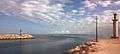 Two lighthouses at the entrance of the port of Gabès
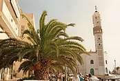 Gabès minaret
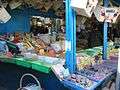 The traditional souk
Notable people
- Gladys Adda, activist, was born here in 1921[18]
- Silvan Shalom, Israeli politician, former minister and Knesset member
- Tahar Haddad, Writer, Feminist advocator, activist, reformer (1899–1935)
- Mohamed Ali El Hammi, one of the founding fathers of Tunisian syndicalism, an activist (1890–1928)
See also
- Gabès Governorate, one of the twenty-four governorates (provinces) of Tunisia
- Gulf of Gabès
- University of Gabès, a public university
References
- "Recensement Général de la Population et de l'Habitat 2014 – Population, logements et ménages par commune et arrondissement". National Institute of Statistics. Archived from the original on 2 March 2016. Retrieved 9 September 2016.CS1 maint: BOT: original-url status unknown (link)
- "Gabès". Collins English Dictionary. HarperCollins. Retrieved 10 August 2019.
- "Gabès". Merriam-Webster Dictionary. Retrieved 10 August 2019.
- "Gabès". Lexico UK Dictionary. Oxford University Press. Retrieved 10 August 2019.
- D. L. Bomgardner, Story of the Roman Amphitheatre (Routledge 2013 ISBN 978-1-13470739-3), p. 123
- Paul Lachlan MacKendrick, The North African Stones Speak (UNC Press 2000 ISBN 978-0-80784942-2), p. 15
- Trismegistos, "Tacapae"
- Annuario Pontificio 2013 (Libreria Editrice Vaticana, 2013, ISBN 978-88-209-9070-1), p. 980
- Stefano Antonio Morcelli, Africa christiana, Volume I, Brescia 1816, p. 295
- Mareth Line
- "Les normales climatiques en Tunisie entre 1981 2010" (in French). Ministère du Transport. Archived from the original on 19 December 2019. Retrieved 4 January 2020.
- "Données normales climatiques 1961-1990" (in French). Ministère du Transport. Archived from the original on 21 December 2019. Retrieved 4 January 2020.
- "Les extrêmes climatiques en Tunisie" (in French). Ministère du Transport. Archived from the original on 21 December 2019. Retrieved 4 January 2020.
- "Réseau des stations météorologiques synoptiques de la Tunisie" (in French). Ministère du Transport. Retrieved 4 January 2020.
- "Gabès Climate Normals 1961–1990". National Oceanic and Atmospheric Administration. Retrieved January 24, 2015.
- "Gabès Climate and Weather Averages, Tunisia". Weather2Travel. Retrieved 19 July 2014.
- Oasis de Gabès - UNESCO World Heritage Centre
- Professor Henry Louis Gates, Jr.; Professor Emmanuel Akyeampong; Mr. Steven J. Niven (2 February 2012). Dictionary of African Biography. OUP USA. pp. 89–90. ISBN 978-0-19-538207-5.
Notes
- The Station ID for Gabès is 46565111.[14]
External links
| Wikimedia Commons has media related to Gabès. |