El Hamma
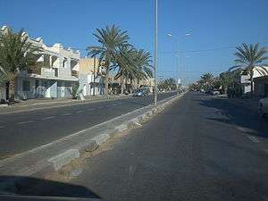
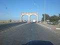
El Hamma (Arabic: الحامة Al Ḥāmmah) is an oasis town located in the Gabès Governorate, 30 kilometers west of Gabès, Tunisia and near the eastern end of Chott el Fejej. Its population in 2014 was 73,512.
El Hamma الحامة Al Ḥāmmah | |
|---|---|
 | |
 El Hamma Location in Tunisia | |
| Coordinates: 33°53′N 9°47′E | |
| Country | |
| Governorate | Gabès Governorate |
| Population (2014) | |
| • City | 41,671 |
| • Metro | 73,512 |
| Time zone | UTC1 (CET) |
History
The town is in the ancestral lands of the Beni Zid tribe and their neighbors the Matmata tribes.
The [[Matmata Berber|Matmata çç (Berber: Imatmaten, Arabic: مطماطة) are a tribal confederation of Berber tribes, specifically Beni Faten, living mainly between Tunisia, Algeria and Morocco. The ancestor of Matmata is called Maskab and nicknamed Matmat. In ancient times the Matmata inhabited the plateaus of Mindas, around Ouancherich (current Ouarsenis), and Mount Guezoul Tiaret and the great interior plains of Tunisia today. Become powerful at the beginning of the eleventh century, they actively participated in the war between Hammad ibn Bologhine and Badis Ibn El Mansour.
Leo d'African visited El Hamma in the mid-sixteenth century. Sayin
It evokes the extremely hot spring that flows a mile and a half from the city and forms the stream that runs through the city in its middle in wide canals.[1]
 El Hamma
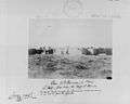 El Hamma in 1886
The English explorer Dr. Thomas Shaw who, as early as 1743, spoke of the city in these terms:
"The city of El Hamma is four leagues west of Gabes: the Tunisians have a small fort and a garrison because it is one of their border places [...] There are several baths, which each have a roof covered with straw, and in their basins, which are about twelve feet square and four deep, there is, for the convenience of those who bathe, stone benches a little to below the surface of the water."[2]
Victor Guérin described the town in 1862
"At one o'clock, we arrive at El Hamma. This oasis is made up of several villages, which are: El Kasr, the most important of all, Dabdaba, where we ask hospitality to Sheikh, Soumbat, Zaouïet El Madjeba and Bou Atouche. Palm plantations watered by running water surround these villages. These waters come from four hot springs, three of which are in Dabdaba and the fourth between Dabdaba and El Kasr. They were formerly enclosed in basins built in very beautiful cut stones and still exist, at least in part, because many blocks have been moved or removed. To each of these basins is attached a small bathhouse of modern construction but divided internally into several compartments that are ancient. The temperature of these sources varies: the hottest is forty-five degrees centigrade, the lowest is thirty-four degrees centigrade. Between Dabdaba and El Kasr once stretched a town called Aqua Tacapitanae, because it depended on Tacape, from which it was separated by an interval of 18 Roman miles. It is mentioned in the Route of Antonin. It is now completely destroyed and its debris has been used to build the modern villages that have succeeded it and a fort called Bordj El Hamma "[3]
At the end of the 19th century, André Martel,[4] estimated Beni Zid tribe had nearly 19,000 inhabitants, a quarter of whom permanently reside in the oasis of El Hamma. today a majority most of the Beni Zid are settled permanently in the Oasis.
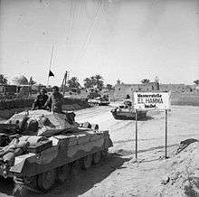
On the 29th March 1943, New Zealand and British forced defeated the Germans at the Battle of the Mareth Line and entered El Hamma.
The completion of several deep bore holes to supply water to the Gabès cement plant in the 1980s and 1990s, saw a drying up of several hot springs including Aïn Echoffa, and a degradation of the palm grove farms.
Economics
Agriculture has long been the main economic sector of activity in Hammah, the city's economy has diversified in recent years and the industry employs more than a third of the towns assets.[5]
The hotel and tourism sector is also experiencing particularly significant growth thanks to a rehabilitation program co-financed by the World Bank.[6][7]
References
- Léon l'Africain, De l'Afrique, impr. de L. Cordier, Paris, 1830, tome II, livre 5, p. 67-68
- "Thomas Shaw, Voyages de M. Shaw dans plusieurs provinces de la Barbarie et du Levant, éd. Jean Neaume, La Haye, 1743, tome I, chap. 5, p. 276-277.
- ↑ Victor Guérin, Voyage archéologique dans la régence de Tunis, éd. Plon, Paris, 1862, p. 235.
- André Martel, Les confins saharo-tripolitains de la Tunisie (1811-1911), éd. Presses universitaires de France, Paris, 1965
- Sources: National Institute of Statistics (2004 census)
- "Archived copy". Archived from the original on 2007-09-27. Retrieved 2019-06-27.CS1 maint: archived copy as title (link)
- http://archives.lapresse.tn/index.php?opt=15&categ=1&news=52699%5B%5D