Thala, Tunisia
Tala (Arabic: تالة, romanized: Tāla) is a town and commune in Tunisia. It is located in the Kasserine Governorate since 1956. As of the 2004 census it had 13,968 inhabitants.[1] The altitude of Thala is 1,017 metres (3,337 ft), which makes it the highest and the coldest[2] town in the country.
Tala Tāla تالة | |
|---|---|
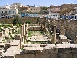 Ruins at Tala | |
 Tala Location in Tunisia | |
| Coordinates: 35°34′N 8°40′E | |
| Country | Tunisia |
| Governorate | Kasserine |
| Elevation | 1,017 m (3,337 ft) |
| Population (2014)[1] | |
| • Total | 18,230 |
History
During the Roman Empire Thala was the site of a Roman colony called Thélepte, and was the seat of an ancient bishopric. It still has a titular absentee bishop (currently the auxiliary Bishop of Sydney, Richard Umbers), who is appointed by the Pope. [3]
In 1906, an attack by local bedouin on the French civil administration offices during the Thala-Kasserine Disturbances was the first violent resistance to French authority under the protectorate.[4]
Thala was the scene of fierce fighting during World War II, in the late stages of the Battle of the Kasserine Pass. The 10th Panzer Division sought to exploit its early success against US forces. In a series of defensive actions on 21 February 1943, the British 26th Armoured Brigade, part of Nickforce, blocked an advance by the German division's Kampfgruppe which, despite coming under the personal command of Erwin Rommel, were finally unable to make headway through fire from British tanks and artillery.[5]
Geography
Climate
The climate in Thala is semi-arid (BSk, according to the Köppen climate classification), with Mediterranean influences. Summers are moderately hot (by Saharan standards) and dry, and winters are chilly and wetter. Snowfalls can occur sometimes.
| Climate data for Thala, Tunisia (1981–2010, extremes 1976–2017) | |||||||||||||
|---|---|---|---|---|---|---|---|---|---|---|---|---|---|
| Month | Jan | Feb | Mar | Apr | May | Jun | Jul | Aug | Sep | Oct | Nov | Dec | Year |
| Record high °C (°F) | 21.2 (70.2) |
27.5 (81.5) |
29.9 (85.8) |
30.9 (87.6) |
38.2 (100.8) |
39.3 (102.7) |
41.0 (105.8) |
40.6 (105.1) |
39.1 (102.4) |
33.6 (92.5) |
27.1 (80.8) |
24.8 (76.6) |
41.0 (105.8) |
| Average high °C (°F) | 9.2 (48.6) |
10.6 (51.1) |
13.7 (56.7) |
17.2 (63.0) |
22.8 (73.0) |
28.4 (83.1) |
32.0 (89.6) |
31.4 (88.5) |
26.1 (79.0) |
21.1 (70.0) |
14.6 (58.3) |
10.4 (50.7) |
19.8 (67.6) |
| Daily mean °C (°F) | 5.5 (41.9) |
6.3 (43.3) |
8.8 (47.8) |
11.6 (52.9) |
16.5 (61.7) |
21.4 (70.5) |
24.8 (76.6) |
24.4 (75.9) |
19.9 (67.8) |
16.0 (60.8) |
10.5 (50.9) |
6.9 (44.4) |
14.4 (57.9) |
| Average low °C (°F) | 2.5 (36.5) |
2.7 (36.9) |
4.5 (40.1) |
6.6 (43.9) |
10.8 (51.4) |
15.1 (59.2) |
18.3 (64.9) |
18.4 (65.1) |
15.0 (59.0) |
11.8 (53.2) |
7.0 (44.6) |
3.8 (38.8) |
9.7 (49.5) |
| Record low °C (°F) | −8.4 (16.9) |
−6.9 (19.6) |
−3.2 (26.2) |
−2.5 (27.5) |
0.4 (32.7) |
4.9 (40.8) |
6.9 (44.4) |
9.5 (49.1) |
6.3 (43.3) |
1.8 (35.2) |
−2.9 (26.8) |
−4.6 (23.7) |
−8.4 (16.9) |
| Average precipitation mm (inches) | 41.9 (1.65) |
28.1 (1.11) |
46.0 (1.81) |
42.9 (1.69) |
43.6 (1.72) |
31.1 (1.22) |
10.9 (0.43) |
25.5 (1.00) |
42.4 (1.67) |
32.2 (1.27) |
43.4 (1.71) |
39.6 (1.56) |
427.6 (16.84) |
| Average precipitation days (≥ 1.0 mm) | 6.5 | 5.4 | 7.0 | 6.7 | 5.5 | 3.6 | 1.5 | 3.8 | 5.4 | 5.0 | 5.6 | 5.4 | 61.4 |
| Average relative humidity (%) | 74 | 70 | 71 | 67 | 63 | 55 | 47 | 52 | 60 | 67 | 73 | 73 | 64 |
| Mean monthly sunshine hours | 142.6 | 170.8 | 207.7 | 213.0 | 241.8 | 270.0 | 294.5 | 266.6 | 252.0 | 217.0 | 153.0 | 151.9 | 2,580.9 |
| Source: Institut National de la Météorologie (precipitation days/humidity/sun 1961–1990)[6][7][8][note 1] | |||||||||||||
Notes
- The Station ID for Thala is 64646311.[9]
References
- Recensement de 2004 (Institut national de la statistique) Archived 2015-09-24 at the Wayback Machine (in French)
- "Thala, Thala Ouest, Thala, Gouvernorat de Kasserine, Tunisia". www.mindat.org. Retrieved 2020-05-29.
- Donovan, Ned. "The bishops who've never seen their dioceses". Catholic Herald.
- Masri, Safwan M. (2017-09-05). Tunisia: An Arab Anomaly. Columbia University Press. ISBN 978-0-231-54502-0.
- United States Army in World War II - Mediterranean Theater of Operations - Northwest Africa: Seizing the Initiative In the West, by George F. Howe, Department of the Army 1957 (pp. 464-466)
- "Les normales climatiques en Tunisie entre 1981 2010" (in French). Ministère du Transport. Archived from the original on 19 December 2019. Retrieved 20 December 2019.
- "Données normales climatiques 1961-1990" (in French). Ministère du Transport. Archived from the original on 21 December 2019. Retrieved 20 December 2019.
- "Les extrêmes climatiques en Tunisie" (in French). Ministère du Transport. Archived from the original on 21 December 2019. Retrieved 20 December 2019.
- "Réseau des stations météorologiques synoptiques de la Tunisie" (in French). Ministère du Transport. Retrieved 20 December 2019.