Fords, New Jersey
Fords is an unincorporated community and census-designated place (CDP) located within Woodbridge Township, in Middlesex County, New Jersey, United States.[7][8][9] At the 2010 census, the CDP's population was 15,187.[3]
Fords, New Jersey | |
|---|---|
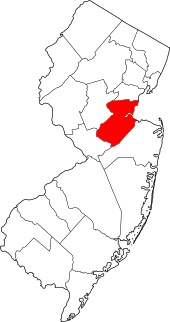
 Map of Fords CDP in Middlesex County. Inset: Location of Middlesex County in New Jersey. | |
| Coordinates: 40.543794°N 74.31292°W | |
| Country | |
| State | |
| County | Middlesex |
| Township | Woodbridge |
| Area | |
| • Total | 2.637 sq mi (6.830 km2) |
| • Land | 2.633 sq mi (6.820 km2) |
| • Water | 0.004 sq mi (0.010 km2) 0.15% |
| Elevation | 138 ft (42 m) |
| Population | |
| • Total | 15,187 |
| • Density | 5,767.5/sq mi (2,226.8/km2) |
| Time zone | UTC-5 (Eastern (EST)) |
| • Summer (DST) | UTC-4 (Eastern (EDT)) |
| ZIP code | 08863[4] |
| Area code(s) | 732/848 |
| FIPS code | 3424030[1][5] |
| GNIS feature ID | 2389094[1][6] |
History and Geography
The area as originally known as Fords Corner and abuts neighboring Edison, part of which was once within Woodbridge Township.[10][11] According to the United States Census Bureau, the CDP had a total area of 2.637 square miles (6.830 km2), including 2.633 square miles (6.820 km2) of land and 0.004 square miles (0.010 km2) of water (0.15%).[1][12]
Demographics
| Historical population | |||
|---|---|---|---|
| Census | Pop. | %± | |
| 1990 | 14,392 | — | |
| 2000 | 15,032 | 4.4% | |
| 2010 | 15,187 | 1.0% | |
| Population sources: 1990-2010[7] 2000[13] 2010[3] | |||
Census 2010
The 2010 United States Census counted 15,187 people, 5,386 households, and 4,012.570 families in the CDP. The population density was 5,767.5 per square mile (2,226.8/km2). There were 5,675 housing units at an average density of 2,155.2 per square mile (832.1/km2). The racial makeup of the CDP was 60.99% (9,263) White, 9.21% (1,399) Black or African American, 0.28% (43) Native American, 20.70% (3,143) Asian, 0.01% (1) Pacific Islander, 5.99% (909) from other races, and 2.82% (429) from two or more races. Hispanic or Latino of any race were 17.40% (2,643) of the population.[3]
The 5,386 households accounted 31.9% with children under the age of 18 living with them; 56.7% were married couples living together; 12.5% had a female householder with no husband present, and 25.5% were non-families. Of all households, 21.1% were made up of individuals, and 8.9% had someone living alone who was 65 years of age or older. The average household size was 2.82 and the average family size was 3.31.[3]
In the CDP, the population age was spread out with 21.7% under the age of 18, 8.8% from 18 to 24, 27.7% from 25 to 44, 28.6% from 45 to 64, and 13.2% who were 65 years of age or older. The median age was 39.2 years. For every 100 females, the population had 93.9 males. For every 100 females ages 18 and older there were 91.9 males.[3]
Census 2000
At the 2000 census[5] there were 15,032 people, 5,591 households, and 4,014 families living in the CDP. The population density was 2,240.9/km2 (5,800.5/mi2). There were 5,688 housing units at an average density of 847.9/km2 (2.,194.9/mi2). The racial makeup of the CDP was 72.86% White, 5.93% African American, 0.11% Native American, 16.11% Asian, 2.71% from other races, and 2.29% from two or more races. Hispanic or Latino of any race were 9.23% of the population.[13]
Of the 5,591 households 31.6% had children under the age of 18 living with them, 56.7% were married couples living together, 10.9% had a female householder with no husband present, and 28.2% were non-families. 23.4% of households were one person and 10.2% were one person aged 65 or older. The average household size was 2.69 and the average family size was 3.21.[13]
The age distribution was 22.5% under the age of 18, 7.0% from 18 to 24, 32.9% from 25 to 44, 22.4% from 45 to 64, and 15.3% 65 or older. The median age was 38 years. For every 100 females, there were 93.3 males. For every 100 females age 18 and over, there were 92.4 males.[13]
The median household income was $61,015 and the median family income was $68,652. Males had a median income of $49,141 versus $36,591 for females. The per capita income for the CDP was $25,917. About 2.4% of families and 3.4% of the population were below the poverty line, including 3.5% of those under age 18 and 5.4% of those age 65 or over.[13]
Education
Fords has three elementary schools — Ford Avenue School #14, Menlo Park Terrace School #19 and Lafayette Estates School #25 — and one middle school, Fords Middle School (Formerly Fords Junior High), all of which are a part of the Woodbridge Township School District. MPT School #19 has a mailing address in Metuchen, however, children who live in parts of Fords attend the school.
Notable people
People who were born in, residents of, or otherwise closely associated with Fords include:
- Tim Mulqueen (born 1966), soccer goalkeeping coach and former goalkeeper who coached the US National Team at the 2008 Summer Olympics in Beijing.[14]
- Craig Coughlin (born 1958), politician, who has served in the New Jersey General Assembly since 2010, where he represents the 19th Legislative District.[15]
See also
References
- Gazetteer of New Jersey Places, United States Census Bureau. Accessed July 21, 2016.
- U.S. Geological Survey Geographic Names Information System: Fords Census Designated Place, Geographic Names Information System. Accessed July 5, 2012.
- DP-1 - Profile of General Population and Housing Characteristics: 2010 Demographic Profile Data for Fords CDP, New Jersey Archived 2020-02-12 at Archive.today, United States Census Bureau. Accessed November 30, 2012.
- Look Up a ZIP Code for Fords, NJ, United States Postal Service. Accessed July 5, 2012.
- U.S. Census website , United States Census Bureau. Accessed September 4, 2014.
- US Board on Geographic Names, United States Geological Survey. Accessed September 4, 2014.
- New Jersey: 2010 - Population and Housing Unit Counts - 2010 Census of Population and Housing (CPH-2-32), United States Census Bureau, August 2012. Accessed November 30, 2012.
- GCT-PH1 - Population, Housing Units, Area, and Density: 2010 - County -- County Subdivision and Place from the 2010 Census Summary File 1 for Middlesex County, New Jersey Archived 2020-02-12 at Archive.today, United States Census Bureau. Accessed November 30, 2012.
- Locality Search, State of New Jersey. Accessed April 18, 2015.
- Virginia B. Troeger and Robert James McEwen, Woodbridge: New Jersey's Oldest Township (Arcadia Publishing, 2002; ISBN 0738523941), p. 103.
- Gannett, Henry (January 28, 1895). "A Geographic Dictionary of New Jersey". U.S. Government Printing Office – via Google Books.
- US Gazetteer files: 2010, 2000, and 1990, United States Census Bureau. Accessed September 4, 2014.
- DP-1 - Profile of General Demographic Characteristics: 2000 from the Census 2000 Summary File 1 (SF 1) 100-Percent Data for Fords CDP, New Jersey Archived 2020-02-12 at Archive.today, United States Census Bureau. Accessed November 30, 2012.
- Giase, Frank. "Springfield native Claudio Reyna will retire today", The Star-Ledger, July 15, 2008. Accessed December 17, 2017. " Tim Mulqueen, who has served a number of roles with the U.S. Soccer Federation, has been named goalkeeper coach for the Olympic men's team. Mulqueen, a Fords native, will join assistant coach Lubos Kubik on coach Peter Nowak's staff."
- http://observer.com/2011/02/craig-j-coughlin-d-fords/. Missing or empty
|title=(help)