Dayton, New Jersey
Dayton is an unincorporated community and census-designated place (CDP) located within South Brunswick, in Middlesex County, New Jersey, United States.[7][8] At the 2010 United States Census, the CDP's population was 7,063.[3]
Dayton, New Jersey | |
|---|---|
 Center of Dayton | |
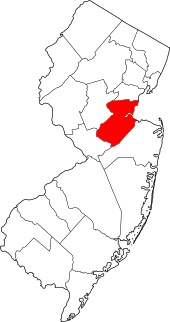
 Map of Dayton CDP in Middlesex County. Inset: Location of Middlesex County in New Jersey. | |
 Dayton Location in Middlesex County  Dayton Location in New Jersey  Dayton Location in the United States | |
| Coordinates: 40.381014°N 74.513355°W | |
| Country | |
| State | |
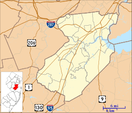
| County | Middlesex |
| Township | South Brunswick |
| Named for | Jonathan Dayton or William L. Dayton |
| Area | |
| • Total | 2.102 sq mi (5.443 km2) |
| • Land | 2.099 sq mi (5.436 km2) |
| • Water | 0.003 sq mi (0.007 km2) 0.13% |
| Elevation | 105 ft (32 m) |
| Population | |
| • Total | 7,063 |
| • Density | 3,365.0/sq mi (1,299.2/km2) |
| Time zone | UTC-5 (Eastern (EST)) |
| • Summer (DST) | UTC-4 (Eastern (EDT)) |
| ZIP code | 08810[4] |
| Area code(s) | 732/848 |
| FIPS code | 3416630[1][5] |
| GNIS feature ID | 02389397[1][6] |
Dayton has a post office with its own ZIP code (08810) that encompasses the entire CDP, as well as some surrounding areas.[4] The community was named for William L. Dayton, a local attorney who later served in the United States Senate[9][10] or for Jonathan Dayton, the youngest person to sign the United States Constitution, who later served as a United States Senator from New Jersey.[11] The area had been known as Cross Roads and was renamed in 1866 to avoid confusion with mail that was sent to another post office that shared the name.[9][10]
Geography
According to the United States Census Bureau, the CDP had a total area of 2.102 square miles (5.443 km2), including 2.099 square miles (5.436 km2) of land and 0.003 square miles (0.007 km2) of water (0.13%).[1][12]
Demographics
| Historical population | |||
|---|---|---|---|
| Census | Pop. | %± | |
| 1990 | 4,321 | — | |
| 2000 | 6,235 | 44.3% | |
| 2010 | 7,063 | 13.3% | |
| Population sources: 1990-2010[7] 2000[13] 2010[3] | |||
Census 2010
The 2010 United States Census counted 7,063 people, 2,288 households, and 1,901.328 families in the CDP. The population density was 3,365.0 per square mile (1,299.2/km2). There were 2,347 housing units at an average density of 1,118.2 per square mile (431.7/km2). The racial makeup of the CDP was 40.15% (2,836) White, 9.19% (649) Black or African American, 0.18% (13) Native American, 46.00% (3,249) Asian, 0.01% (1) Pacific Islander, 1.63% (115) from other races, and 2.83% (200) from two or more races. Hispanic or Latino of any race were 5.78% (408) of the population.[3]
The 2,288 households accounted 52.8% with children under the age of 18 living with them; 70.0% were married couples living together; 10.4% had a female householder with no husband present, and 16.9% were non-families. Of all households, 13.5% were made up of individuals, and 3.9% had someone living alone who was 65 years of age or older. The average household size was 3.09 and the average family size was 3.44.[3]
In the CDP, the population age was spread out with 30.1% under the age of 18, 7.3% from 18 to 24, 29.8% from 25 to 44, 27.1% from 45 to 64, and 5.7% who were 65 years of age or older. The median age was 36.0 years. For every 100 females, the population had 92.5 males. For every 100 females ages 18 and older there were 89.3 males.[3]
Census 2000
At the 2000 census,[5] there were 6,235 people, 2,061 households and 1,690 families living in the CDP. The population density was 1,130.2/km² (2,929.2/mi²). There were 2,252 housing units at an average density of 408.2/km² (1,058.0/mi²). The racial makeup of the CDP was 61.54% White, 9.90% African American, 0.22% Native American, 25.04% Asian, 0.05% Pacific Islander, 1.30% from other races, and 1.96% from two or more races. Hispanic or Latino of any race were 5.15% of the population.[13]
There were 2,061 households of which 52.7% had children under the age of 18 living with them, 68.9% were married couples living together, 10.4% had a female householder with no husband present, and 18.0% were non-families. 14.3% of all households were made up of individuals and 3.3% had someone living alone who was 65 years of age or older. The average household size was 3.03 and the average family size was 3.36.[13]
31.8% of the population were under the age of 18, 6.0% from 18 to 24, 37.3% from 25 to 44, 19.7% from 45 to 64, and 5.2% who were 65 years of age or older. The median age was 34 years. For every 100 females, there were 93.2 males. For every 100 females age 18 and over, there were 90.2 males.[13]
The median household income was $79,050 and the median family income was $83,024. Males had a median income of $56,892 versus $43,500 for females. The per capita income for the CDP was $28,924. About 1.9% of families and 2.4% of the population were below the poverty line, including 1.5% of those under age 18 and 2.7% of those age 65 or over.[13]
As part of the 2000 Census, 15.72% of Dayton's residents identified themselves as being Indian American. This was the fourth-highest percentage of Indian people in any place in the United States with 1,000 or more residents identifying themselves as being of Indian ancestry.[14]
Economy
- Accutest Laboratories, a provider of environmental analytical services to the consulting community, the petroleum, oil, gas and chemical industry and government clients, has an office here.[15]
- Aurobindo Pharma USA, Inc. - Pharmaceutical Distribution Center is situated here.[16]
- Aurolife Pharma LLC - Pharmaceutical Manufacturing Center is located here.[16]
- GMB North America, Inc is located here.[17]
- Haddad Brands, a privately held family business involved in apparel and accessories, is situated here.[18]
Transportation
County Route 522 crosses through the community and U.S. Route 130 travels along the neighborhood's western edge. The New Jersey Turnpike, U.S. Route 1, and New Jersey Route 32 are accessible just outside of Dayton.
Notable people
People who were born in, residents of, or otherwise closely associated with Dayton include:
- Ed Moran (born 1981), retired track and road runner who specialized in various long-distance disciplines who was a gold medalist in the 5000-meter race at the 2007 Pan American Games.[19]
- Sydney Schneider (born 1999), goalkeeper for the UNC Wilmington Seahawks and the Jamaica women's national football team.[20]
References
- Gazetteer of New Jersey Places, United States Census Bureau. Accessed July 21, 2016.
- U.S. Geological Survey Geographic Names Information System: Dayton Census Designated Place, Geographic Names Information System. Accessed November 29, 2012.
- DP-1 - Profile of General Population and Housing Characteristics: 2010 Demographic Profile Data for Dayton CDP, New Jersey Archived 2020-02-12 at Archive.today, United States Census Bureau. Accessed November 29, 2012.
- Look Up a ZIP Code for Dayton, NJ, United States Postal Service. Accessed November 29, 2012.
- U.S. Census website , United States Census Bureau. Accessed September 4, 2014.
- US Board on Geographic Names, United States Geological Survey. Accessed September 4, 2014.
- New Jersey: 2010 - Population and Housing Unit Counts - 2010 Census of Population and Housing (CPH-2-32), United States Census Bureau, August 2012. Accessed November 29, 2012.
- GCT-PH1 - Population, Housing Units, Area, and Density: 2010 - County -- County Subdivision and Place from the 2010 Census Summary File 1 for Middlesex County, New Jersey Archived 2020-02-12 at Archive.today, United States Census Bureau. Accessed November 29, 2012.
- History, Township of South Brunswick. Accessed November 21, 2019. "In 1866, the name was changed from Cross Roads to Dayton, in honor of William L. Dayton, an attorney for the Freehold and Jamesburg Agricultural Railroad. Dayton had helped settle disputes arising from the location of a railroad right-of-way. He was later a U.S. Senator, Vice Presidential nominee, and Minister to France."
- Clayton, W. Woodford. History of Union and Middlesex Counties, New Jersey; With Biographical Sketches of Many of Their Pioneers and Prominent Men, p. 789. Everts and Peck, 1885. Accessed November 21, 2019. "Dayton, formerly known as Cross-Roads,is situated about a quarter of a mile from the New York Division of the Pennsylvania Railroad, southeast of the centre of the township, at the intersection of the Kingston road, the Plainsboro' road, and the Rhode Hall road with the New Brunswick and Cranbury turnpike, and was named in honor of William L. Dayton, of Trenton, the change having been necessitated by the frequent miscarriage of mails intended for that locality, there being another post-office in the State called Cross-Roads."
- Federal Writers' Project (1938). The Ocean Highway: New Brunswick, New Jersey to Jacksonville, Florida. Works Progress Administration. p. 1.
- US Gazetteer files: 2010, 2000, and 1990, United States Census Bureau. Accessed September 4, 2014.
- DP-1 - Profile of General Demographic Characteristics: 2000 from the Census 2000 Summary File 1 (SF 1) 100-Percent Data for Dayton CDP, New Jersey Archived 2020-02-12 at Archive.today, United States Census Bureau. Accessed November 29, 2012.
- Asian Indian Communities, EPodunk. Accessed June 28, 2006.
- http://www.accutest.com/working-with-us-locations-dayton.htm
- http://www.aurobindousa.com/company/corporate-offices/
- https://www.gmb.jp/en/corporate/about_gmb/corp_net/office_005.html
- https://www.haddad.com/contact
- Morris, Tim. "Moran running 10K at U.S. Olympic Trials", Sentinel, June 26, 2008. Accessed October 11, 2018. "The gold medal rests next to his bed as a reminder. 'On days I don't want to run, I look at it,' said Ed Moran, the native of the Dayton section of South Brunswick who won the 5,000-meter run at last year's Pan-American Games in Rio De Janeiro Brazil."
- Sydney Schneider, UNC Wilmington Seahawks. Accessed October 11, 2018. "High School: South Brunswick; Hometown: Dayton, N.J."