Eeyou Istchee (territory)
Eeyou Istchee (/iːjoʊ̯ ɪst͡ʃi/,[1] Northern East Cree: ᐄᔨᔨᐤ ᐊᔅᒌ Iiyiyiu Aschii /ijɪjɪu əstʃi/, Southern East Cree: ᐄᔨᔫ ᐊᔅᒌ Iiyiyuu Aschii /ijɪju əstʃi/ or ᐄᓅ ᐊᔅᒌ Iinuu Aschii /inu əstʃi/, all meaning "The People's Land";[2] French: [iju istʃi]) is a territory equivalent to a regional county municipality (TE) of Quebec, represented by the Grand Council of the Crees. On July 24, 2012, the Quebec government signed an accord with the Cree Nation that resulted in the abolition of the neighbouring municipality of Baie-James and the creation of the new Eeyou Istchee James Bay Regional Government, providing for the residents of neighbouring Jamésie TE and Eeyou Istchee to jointly govern the territory formerly governed by the municipality of Baie-James.[3]
The total land area of Eeyou Istchee is 5,271 km2 (2,035 sq mi). Note that the Grand Council of the Crees sees Eeyou Istchee as a much larger contiguous traditional territory and homeland of 450,000 square kilometres (170,000 sq mi).[4] The total population of the area was 14,131 in 2006, according to the 2006 Canadian Census, and the largest municipality is the Cree village municipality of Chisasibi on the south bank of La Grande River near the northeast shore of James Bay.
Eeyou Istchee TE was created on November 30, 2007.[5] Its territory had previously belonged to the TE of Jamésie. While most of Eeyou Istchee is enclaved within Jamésie TE, the Cree reserved land (TC) and Cree village municipality (VC) of Whapmagoostui lie north of the 55th parallel north and are enclaved within Kativik TE.
Together with the TEs of Jamésie and Kativik, it forms the region and census division (CD) of Nord-du-Québec.
Communities
| Census Code | Name | Type | Population 2011 | Population 2006 | Total dwellings | Dwellings usual res. | Land Area |
|---|---|---|---|---|---|---|---|
| 2499055 | Chisasibi | VC | 0 | 0 | 0 | 0 | 491.63 |
| 2499814 | Chisasibi | TC | 4484 | 3972 | 1050 | 923 | 828.18 |
| 2499045 | Eastmain | VC | 0 | 0 | 0 | 0 | 316.91 |
| 2499810 | Eastmain | TC | 767 | 650 | 226 | 188 | 147.47 |
| 2499030 | Mistissini | VC | 0 | 0 | 0 | 0 | 514.30 |
| 2499804 | Mistissini | TC | 3427 | 2897 | 952 | 845 | 865.76 |
| 2499040 | Nemaska | VC | 0 | 0 | 0 | 0 | 51.18 |
| 2499808 | Nemaska | TC | 712 | 642 | 226 | 200 | 96.57 |
| 2499818 | Oujé-Bougoumou | TC | 725 | 606 | 251 | 183 | 2.54 |
| 2499035 | Waskaganish | VC | 0 | 0 | 0 | 0 | 277.76 |
| 2499806 | Waskaganish | TC | 2206 | 1864 | 496 | 467 | 505.37 |
| 2499010 | Waswanipi | VC | 0 | 0 | 0 | 0 | 211.52 |
| 2499802 | Waswanipi | TC | 1777 | 1473 | 513 | 413 | 415.64 |
| 2499050 | Wemindji | VC | 0 | 0 | 0 | 0 | 171.06 |
| 2499812 | Wemindji | TC | 1378 | 1215 | 377 | 333 | 377.95 |
| 2499070 | Whapmagoostui | VC | 0 | 0 | 0 | 0 | 122.53 |
| 2499816 | Whapmagoostui | TC | 874 | 812 | 221 | 206 | 189.88 |
| Eeyou Istchee total | TE | 16350 | 14131 | 4312 | 3758 | 5586.25 | |
The TE of Eeyou Istchee is governed by the Grand Council of the Crees by the Cree Nation Government. It consists of the following municipal units:
- the Cree reserved lands listed above (with code = TC, terre réservée crie):
- the Cree village municipalities listed above (with code VC, municipalité de village cri)
Somewhat confusingly, the Commission de toponymie du Québec refers to the Cree reserved lands as "Cree villages" (village cri), as distinct from the "Cree village municipalities" (municipalité de village cri).[7] However, from a practical point of view this makes sense, since the population resides in these reserved lands.
Definitions
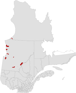
The above map indicates the Category I lands reserved for the Cree under the terms of the James Bay and Northern Quebec Agreement. Though formally designated as a TE for these areas in 2007, the term "Eeyou Istchee" has long been applied by Quebec Cree to refer to themselves and all their traditional hunting lands. In Category II lands, owned by the Crown-in-right-of-Quebec, hunting, fishing and trapping rights are reserved for the Cree, while forestry, mining and tourism development authority is shared. In Category III lands, some specific hunting and harvesting rights are reserved for the Cree, but all other rights are shared subject to a joint regulatory scheme. Roughly 14,000 km2 fall into Category I, 150,000 km2 in Category II, and 908,000 km2 - almost 60 percent all land in Quebec - are in Category III.
Notes
- https://www.youtube.com/watch?v=R-wJ5CzpVa8
- http://dictionary.eastcree.org/Words/
- Lia Lévesque (24 July 2012). "Québec et les Cris signent une entente pour un gouvernement régional" [Quebec and the Cree sign an agreement for a regional government]. La Presse. Retrieved 2012-07-24.
- http://www.gcc.ca/pdf/Cree-Vision-of-Plan-Nord.pdfsee "Map 1.4" Archived 2012-07-16 at the Wayback Machine
- "Modifications aux municipalités du Québec, novembre 2007" [Modifications to the municipalities of Quebec, November 2007] (PDF) (in French). Institut de la Statistique du Québec. November 2007. ISSN 1715-6408. Archived from the original (PDF) on 2013-09-27.
- Nord-du-Québec (Census division)
- "Liste complète des types d'entités et leurs définitions". Banque de noms de lieux du Québec (in French). Commission de toponymie du Québec. Archived from the original on 2012-04-19. Retrieved 2012-05-02.
References
- Database of the geographical code of Quebec
- Regional maps of municipal and RCM/TE boundaries from the Ministère des Affaires municipales et des Régions. As of January 2008, the Nord-du-Québec map shows Jamésie territory as it was before the creation of Eeyou Istchee.
External links
| Wikimedia Commons has media related to Eeyou Istchee. |
- Grand Council of the Crees (Eeyou Istchee) official website
- « Eeyou Istchee » : terres des Cris, Archives de Radio-Canada
- Eeyou Istchee Tourism site
Adjacent Counties & Equivalent Territories | ||||||||||
|---|---|---|---|---|---|---|---|---|---|---|
| ||||||||||
| Regional county municipalities and equivalent territories |
|
|---|---|
| Municipalities |
|
| Subdivisions | |
|---|---|
| Communities | |
| Major cities | |
Portal:Canada | |