Whapmagoostui
Whapmagoostui (Cree: ᐙᐱᒫᑯᔥᑐᐃ/Wâpimâkuštui, "place of the beluga") is the northernmost Cree village in Quebec, Canada, located at the mouth of the Great Whale River (French: Grande Rivière de la Baleine) on the coast of Hudson Bay in Nunavik. About 906 Cree with about 650 Inuit,[3] living in the neighbouring village of Kuujjuarapik. The community is accessible only by air (Kuujjuarapik Airport) and, in late summer, by boat. Whapmagoostui is about 250 km (160 mi) north of the nearest Cree village, Chisasibi.
Whapmagoostui ᐙᐱᒫᑯᔥᑐᐃ | |
|---|---|
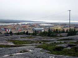 Partial view of the village, as seen from the hills to the east | |
 Whapmagoostui | |
| Coordinates: 55°18′00″N 077°48′00″W | |
| Country | Canada |
| Province | Quebec |
| Region | Eeyou Istchee |
| Established | 1821 (HBC post) |
| Incorporated | 1979 |
| Government | |
| • Type | Cree territory |
| • Chief | Louisa Wynne |
| Area | |
| • Total | 202.49 km2 (78.18 sq mi) |
| • Land | 189.88 km2 (73.31 sq mi) |
| Population (2016)[2] | |
| • Total | 984 |
| • Density | 5.2/km2 (13/sq mi) |
| Time zone | UTC−05:00 (EST) |
| • Summer (DST) | UTC−04:00 (EDT) |
| Postal Code | J0M 1G0 |
| Area code(s) | 819 (929 exchange) |
| Website | www |
Although the permanent cohabitation of Inuit and Cree at the mouth of the Great Whale River goes back only 1950, the two nations were rubbing shoulders in the area for a very long time, with the Inuit close to the coast and the Cree more in the interior.
History
The Cree have hunted and fished along the Hudson Bay coast long before the arrival of Europeans, it was not until 1820 when a Hudson's Bay Company trading post was built here,[4] known variously as Great Whale River House, Great Whale River or just Great Whale. On maps of 1851 and 1854, the post is called Whale River House and Whale House.[5] Protestant and Catholic missions settled there in the 1880s. In 1895, a weather station was set up by the Federal Government. Medical and police services began to be offered in the first half of the 20th century.[4] Yet the Cree would not settle here permanently and only used it as a summer encampment.
In 1940 the Cree were forced to give up their nomadic way of life when the American army opened a military air base here. [5] In 1941, the HBC post closed. After the World War II in 1948, the military base was transferred to the Canadian government. And in 1955, it began operating a Mid-Canada Line radar station.[4] Though the radar station was not operational for long and closed in 1965, it established the village permanently.
In 1961, when the Quebec Government decided to give French names to northern settlements, the name Great Whale River was replaced with Grande-Baleine which itself was replaced a year later with Poste-de-la-Baleine.[6] In 1979, the Cree Village Municipality, identified as Whapmagoostoo, was established. The Cree village itself was officially named Whapmagoostui in 1986, from then on replacing all other toponyms.[5]
In 2013, seven young men from the community journeyed 1,600 km (990 mi) for "Nishiyuu", in support of Idle No More.
Demographics
Population:[7]
- Population in 2016: 984 (2011 to 2016 population change: +12.6%)[2]
- Population in 2011: 874 (2006 to 2011 population change: +7.6%)
- Population in 2006: 812 (2001 to 2006 population change: +4.4%)
- Population in 2001: 778 (2001 to 2006 population change: +24.3%)
- Population in 1996: 626 (1996 to 1996 population change: +23.2%)
- Population in 1991: 508
Education
The Cree School Board operates the Badabin Eeyou School (Cree: ᐹᑖᐱᓐ ᐄᔨᔨᐤ ᒋᔅᑯᑎᒫᑑᑭᒥᒄ), which includes the includes the Meeyow Bee Nooquow School. In 1982, the school was built, and in 1989, the first high school class graduated.[8]
References
- Total area: Ministère des Affaires Municipales et Régions
Land area: Statistics Canada - "Census Profile". Canada 2016 Census. Statistics Canada.
- Aboriginal identity population in 2001
- "Kuujjuarapik". Nunavik Tourism Association. Retrieved 2008-12-16.
- "Whapmagoostui" (in French). Commission de toponymie du Québec. Archived from the original on 2015-12-08. Retrieved 2008-12-16.
- "Kuujjuarapik" (in French). Commission de toponymie du Québec. Retrieved 2008-12-16.
- Statistics Canada: 1996, 2001, 2006, 2011, 2016 census
- "Badabin Eeyou School." Cree School Board. Retrieved on September 22, 2017.
Further reading
- Adelson, Naomi. Practices and Perceptions of Health of the James Bay Cree of Whapmagoostui, Quebec Final Report. Montréal: McGill University], 1991.
- Lussier, Catherine, Carole Lévesque, and Ginette Lajoie. Northern Ecosystem Initiative A Preliminary Community Perspective on Environmental Priorities, Whapmagoostui and Chisasibi. Montréal: INRS Culture et société, 2000.