Warwick, New York
Warwick is a town in the southwest part of Orange County, New York, United States. Its population was 32,065 at the 2010 census. The town contains three villages (Florida, Greenwood Lake, and Warwick) and eight hamlets (Amity, Bellvale, Edenville, Greenwood Forest Farms, Little York, New Milford, Pine Island, and Sterling Forest).
Warwick, New York | |
|---|---|
Town | |
 Pedestrians flock to Warwick Farmer’s Market | |
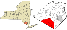 Location in Orange County and the state of New York | |
 Warwick, New York Location within the state of New York | |
| Coordinates: 41°15′40″N 74°21′19″W | |
| Country | United States |
| State | New York |
| County | Orange |
| Government | |
| • Town Supervisor | Michael P. Sweeton |
| Area | |
| • Total | 104.87 sq mi (271.61 km2) |
| • Land | 101.29 sq mi (262.33 km2) |
| • Water | 3.58 sq mi (9.28 km2) |
| Elevation | 538 ft (164 m) |
| Population (2010) | |
| • Total | 32,065 |
| • Estimate (2018)[2] | 31,185 |
| • Density | 308.84/sq mi (119.24/km2) |
| Time zone | UTC-5 (Eastern (EST)) |
| • Summer (DST) | UTC-4 (EDT) |
| ZIP code | 10990 |
| Area code(s) | 845 |
| FIPS code | 36-78366[3] |
| GNIS feature ID | 0979600[4] |
| Website | http://www.townofwarwick.org |
History
In the early 1700s, one of the original patent holders, Benjamin Aske, named his land "Warwick", presumably after an area of England near his original ancestral home. He began to sell it off to settlers in 1719. His first parcel of land, 100 acres, was sold to Lawrence Decker. Other familiar family names of the Valley appeared in subsequent years. The white population of the valley grew rapidly from 1730 to 1765, and the pre-existing indigenous native people declined as forests and land were cleared for pasture and were re-organized. By the start of the American Revolution, almost all of the native population had disappeared in various ways.[5] So the region has been referred to as Warwick since the early eighteenth century, but the town of Warwick was officially created in 1788.[6]
During the American War for Independence, Warwick was the site of a Continental Army encampment. The Hudson River Chain was forged at Stirling Iron Works in Warwick, preventing the British Navy from sailing up the Hudson River. In 1783, George Washington traveled through Warwick, stopping at Baird's Tavern and spending the night in the home of John Hathorn.

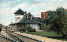
Warwick is situated along a freight rail line, which, as it did with many other towns in Orange County (Goshen, Middletown, Newburgh), contributed to the growth of the area. The nineteenth-century writer and naturalist Henry William Herbert, writing as Frank Forrester, popularized the area with his 1845 book, "The Warwick Woodlands."[7] Today, the town of Warwick is a rural community with many agricultural pursuits that stimulate its economy.
Geography
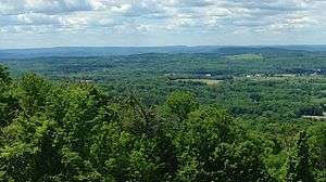
The town of Warwick comprises the southern tip of Orange County. It borders the townships of Vernon and West Milford to the south, both in the state of New Jersey. To its north, Warwick is bordered by Chester via Sugar Loaf, Orange County's oldest hamlet, antedating both Warwick and Chester, and which was part of Warwick until the mid-nineteenth century. To its east, Warwick is bordered by the town of Tuxedo, home of the New York Renaissance Faire and the hamlet of Tuxedo Park.
According to the United States Census Bureau, the town is the second largest township in New York State and has a total area of 104.9 square miles (271.6 km²), of which 101.7 square miles (263.3 km²) is land and 3.2 square miles (8.3 km²) (3.04%) is water. Greenwood Lake is Orange County's largest lake, and is bisected by the border between New Jersey (to the south) and New York (on its north). Glenmere Lake, an extremely critical endangered species habitat, is bisected by Warwick and Chester.
Warwick is served by Warwick Municipal Airport and two regional state highways, New York State Route 17A (NY 17A) and NY 94. The Appalachian Trail passes through Warwick, which has been designated an Appalachian Trail Community.[8]
Demographics
| Historical population | |||
|---|---|---|---|
| Census | Pop. | %± | |
| 1820 | 4,506 | — | |
| 1830 | 5,013 | 11.3% | |
| 1840 | 5,113 | 2.0% | |
| 1850 | 4,902 | −4.1% | |
| 1860 | 4,628 | −5.6% | |
| 1870 | 5,736 | 23.9% | |
| 1880 | 5,699 | −0.6% | |
| 1890 | 6,000 | 5.3% | |
| 1900 | 6,403 | 6.7% | |
| 1910 | 7,141 | 11.5% | |
| 1920 | 7,462 | 4.5% | |
| 1930 | 8,017 | 7.4% | |
| 1940 | 9,369 | 16.9% | |
| 1950 | 9,828 | 4.9% | |
| 1960 | 12,551 | 27.7% | |
| 1970 | 16,956 | 35.1% | |
| 1980 | 20,976 | 23.7% | |
| 1990 | 27,193 | 29.6% | |
| 2000 | 30,764 | 13.1% | |
| 2010 | 32,065 | 4.2% | |
| Est. 2018 | 31,185 | [9] | −2.7% |
| U.S. Decennial Census[10] | |||
As of the census[3] of 2000, there were 30,764 people, 10,868 households, and 7,955 families residing in the town. The population density was 302.6 people per square mile (116.8/km²). There were 11,818 housing units at an average density of 116.2 per square mile (44.9/km²). The racial makeup of the town was 91.06% White, 4.51% Black or African American, 0.31% Native American, 0.85% Asian, 0.05% Pacific Islander, 1.60% from other races, and 1.61% from two or more races. Hispanic or Latino of any race were 6.47% of the population.
There were 10,868 households out of which 38.5% had children under the age of 18 living with them, 61.7% were married couples living together, 8.6% had a female householder with no husband present, and 26.8% were non-families. 22.0% of all households were made up of individuals and 9.1% had someone living alone who was 65 years of age or older. The average household size was 2.74 and the average family size was 3.25.
In the town, the population was spread out with 27.2% under the age of 18, 5.6% from 18 to 24, 31.3% from 25 to 44, 24.6% from 45 to 64, and 11.3% who were 65 years of age or older. The median age was 38 years. For every 100 females, there were 100.7 males. For every 100 females age 18 and over, there were 98.2 males.
Education
The Warwick Valley Central School District serves as the public school system for Warwick residents and residents of the southern portion of the town of Chester. It does not serve residents of the villages Greenwood Lake or Florida.
Festivals
Applefest is an annual outdoor festival attracting up to 35,000 people each year in October.[11]
The Hudson Valley Jazz Festival, originally named the Warwick Valley Jazz Festival, takes place during the summer.[12][13]
The annual George Washington Celebration is a tradition that celebrates when the Founding Father, Gen. Washington came to Warwick and enjoyed a grog with his men in Baird's Tavern. This free community-wide tradition takes place the 4th weekend in July, and is carried on by the Historical Society of the Town of Warwick, also known as the Warwick Historical Society, a non-profit organization dedicated to Warwick since its inception in 1906. Visit www.whsny.org for information.
Transportation
Warwick is served by the 196 & 197 buses to Manhattan (operated by New Jersey Transit). It is also served by the Warwick inter-municipal bus.[14][15]
Communities and locations in the town of Warwick
- Warwick – village located by the junction of NY 94 and NY 17A.
- Florida – village located on NY 17A.
- Greenwood Lake – village located on NY 17A at the north end of Greenwood Lake.
- Amity – hamlet located between Edenville and Pine Island near the New Jersey state line. It is served by the Amity Station of the Pine Island Fire Department and is the site of the Amity Presbyterian Church, which was first opened in 1796. Amity is also home to the Crystal Inn, a famous restaurant and bar located on Amity Road, which opened in 1965.
- Bellvale – hamlet on NY 17A between Warwick village and Greenwood Lake.
- Black Walnut Hill – hamlet north of Hoopstick on Pulaski Highway.
- Center – an historic hamlet identified solely by the post office that was located at the Warwick Woodlands Hotel from 1909-1916 on the west shore of Greenwood Lake north of Furnace Brook. An earlier post office by the name of Warwick Woodlands, NY, operated at the same location from 1882-1891.
- Durland – hamlet northeast of Warwick village and west of Wickham Lake.
- Edenville – hamlet in the western part of Warwick, on Pine Island Turnpike, just off County Route 1 (CR 1).
- Greenwood Forest Farms – an early area retreat for African-American families.
- Hoopstick – hamlet north of Pine Island in the "black dirt" on Pulaski Highway, historically the home of nineteenth century barrel hoop makers.
- Lakeville – hamlet located at the south end of Sterling Lake.
- Liberty Corners – hamlet on CR 88, near the New Jersey state line in the southwest part of the town.
- Little York – hamlet east of Pine Island.
- New Milford – hamlet near the New Jersey state line on NY 94.
- Newport – hamlet south of Pine Island.
- Pine Island – hamlet at the junction of CR 1 (Pine Island Turnpike), CR 6 (Pulaski Highway), and CR 26 (Glenwood Road) near the northwest town line. It is the commercial center of the "black dirt" region.
- Quaker Creek – hamlet south of Snufftown on Pulaski Highway, directly on the border with the town of Goshen.
- Snufftown – hamlet north of Pine Island near the town line; historically considered the "Snufftown section of the village of Florida", it is last settlement in the Florida union-free school district. Named for the habit of the early twentieth century farmers who relaxed on the front porch of one of the earliest homesteads, drinking beer, and chewing snuff.
- Sterling Forest – a hamlet located at the New Jersey state line on the east shore of Greenwood Lake, and served by the Sterling Forest, NY, post office. It was the site of the first American rocket airplane flight that carried mail from NY to NJ on February 23, 1936. Babe Ruth often rented a cabin there for the summer season during his retirement.
- Wisner – hamlet northeast of Warwick village.
- Cascade Lake – a small lake in the hills on the southern part of town.
- Glenmere Lake – a reservoir that hosts New York's last population of the endangered northern cricket frog.
- Greenwood Lake – a lake on the border of New York and New Jersey.
- Mount Adam – a granite and shale mount directly on the border of the "black dirt," near the northern town line and directly southwest of Mount Eve.
- Mount Eve – a granite and shale mount, one-quarter mile south of Snufftown and northeast of Mount Adam.
- Pochuck Neck – a location near the west town line between Liberty Corners and Pine Island.
- Sterling Lake – a lake in the eastern part of the town.
- Wallkill River National Wildlife Refuge – northernmost part only.
- Wickham Lake – a small lake near the north town line.
Notable people
- Damon Amendolara - radio host on CBS Sports Radio
- Carleton Carpenter, actor.
- E. Jean Carroll – advice columnist with Elle magazine.
- James Cromwell – actor and long term activist for community; Issues concerning environment.
- Jasper Francis Cropsey – Hudson River School artist.
- Gus Dapperton - indie pop musician.
- Susan J. Elliott – author and media commentator, owns a residence in Pine Island.
- James Emery - jazz guitarist and founding member of the String Trio of New York.
- Frederick Franck - painter, sculptor, and author.
- John Hathorn – Commander in the American Revolutionary War and New York politician.
- Derek Jeter – owns a residence on the western shore of Greenwood Lake.
- Richard Kiley – actor.
- Bill Pennington – sports reporter for The New York Times and author of multiple books.
- William H. Seward – Secretary of State to Abraham Lincoln, born and raised in the village of Florida.
- Jimmy Sturr – eighteen-time Grammy Award Winner, grew up and resides in the village of Florida.
- Jonathan Talbot – internationally known painter, collage artist, and author.
- Gretchen Wyler – American actress and dancer
See also
- Michael Jackson – "Earth Song" music video
- Warwick Advertiser
References
- "2016 U.S. Gazetteer Files". United States Census Bureau. Retrieved July 5, 2017.
- https://www.census.gov/quickfacts/fact/table/warwicktownorangecountynewyork/PST045218
- "U.S. Census website". United States Census Bureau. Retrieved January 31, 2008.
- "US Board on Geographic Names". United States Geological Survey. October 25, 2007. Retrieved January 31, 2008.
- A Short History of the Warwick Valley - Dr. Richard Hull's History of Warwick. S. Gardner, July 1999. albertwisnerlibrary.org. Retrieved November 2019.
- U.S. Geological Survey Geographic Names Information System: Town of Warwick; retrieved, 26 Märch 2014
- Merritt, Jim (December 1996). "The Exile". Field & Stream.
- "Warwick to Mark Appalachian Trail Community Day". New York–New Jersey Trail Conference. June 30, 2012.
- https://www.census.gov/quickfacts/fact/table/warwicktownorangecountynewyork/PST045218
- "Census of Population and Housing". Census.gov. Retrieved June 4, 2015.
- "Celebrate annual Applefest in Warwick next week". Times Herald-Record. Middletown, NY. October 1, 2009. Retrieved April 18, 2011.
- Sparks, Leonard (August 29, 2010). "Warwick hosts its 1st jazz festival". Times Herald-Record. Middletown, NY. Retrieved April 18, 2011.
- "Press". Hudsonvalleyjazzfest.org. Retrieved October 10, 2012.
- Countywide map transitorange.info
- Town Services/Bus Schedules townofwarwick.org Archived December 3, 2013, at the Wayback Machine
External links

- Town of Warwick
Municipalities and communities of Orange County, New York, United States | ||
|---|---|---|
| Cities | 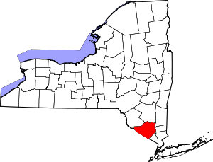 | |
| Towns | ||
| Villages | ||
| CDPs | ||
| Other hamlets |
| |