Districts of Balochistan, Pakistan
Balochistan is one of the four provinces of Pakistan. It is situated in the South Eastern part of the country. Quetta is the provincial capital and largest city of the province. It occupies the very southeastern-most portion of the Iranian Plateau, the site of the earliest known farming settlements in the pre-Indus Valley Civilization era, the earliest of which was Mehrgarh, dated at 7000 BC, located in modern-day Pakistani province of Balochistan. It covers an area of 347,190 square kilometres (134,050 sq mi) and it is Pakistan's largest province by area, constituting 44% of Pakistan's total land mass. Balochistan is divided into 34 districts.
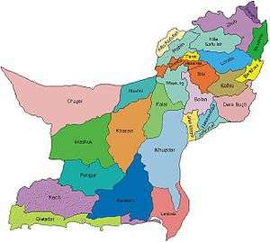
Districts of Balochistan Pakistan
list of districts
| Map | Sr. No. | District | Headquarters | Area (km2) | Population (1998) | Population (2017) | Density (people/km2) |
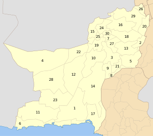 |
1 | Awaran | Awaran | 12,510 | 118,173 | 121,680 | 4 |
| 2 | Barkhan | Barkhan | 3,514 | 103,545 | 171,556 | 29 | |
| 3 | Kachhi (Bolan) | Dhadar | 7,499 | 288,056 | 237,030 | 38 | |
| 4 | Chagai | Chagai | 44,748[1] | 300,000 | 7 | ||
| 5 | Dera Bugti | Dera Bugti | 10,160 | 181,310 | 18 | ||
| 6 | Gwadar | Gwadar | 12,637 | 185,498 | 15 | ||
| 7 | Harnai[2][note 1] | Harnai | 4,096 | 140,000 | 19 | ||
| 8 | Jafarabad | Dera Allahyar | 2,445 | 432,817 | 177 | ||
| 9 | Jhal Magsi | Jhal Magsi | 3,615 | 109,941 | 30 | ||
| 10 | Kalat | Kalat | 6,622 | 237,834 | 36 | ||
| 11 | Kech (Turbat) | Turbat | 22,539 | 413,204 | 911000 | 18 | |
| 12 | Kharan | Kharan | 18958 | 96900 | 156,152 | 4 | |
| 13 | Kohlu | Kohlu | 7,610 | 99,846 | 214,805 | 13 | |
| 14 | Khuzdar | Khuzdar | 35,380 | 417,466 | 12 | ||
| 15 | Killa Abdullah | Chaman | 3,293 | 370,269 | 112 | ||
| 16 | Killa Saifullah | Killa Saifullah | 6,831 | 193,553 | 28 | ||
| 17 | Lasbela | Uthal | 15,153 | 312,695 | 21 | ||
| 18 | Loralai | Loralai | 9,830 | 295,555 | 30 | ||
| 19 | Mastung | Mastung | 5,896 | 179,784 | 30 | ||
| 20 | Musakhel | Musa Khel Bazar | 5,728 | 134,056 | 23 | ||
| 21 | Nasirabad | Dera Murad Jamali | 3,387 | 245,894 | 73 | ||
| 22 | Nushki[3] | Nushki | 5,797 | 137,500 | 23 | ||
| 23 | Panjgur | Panjgur | 16,891 | 234,051 | 14 | ||
| 24 | Pishin | Pishin | 7,819 | 367,183 | 47 | ||
| 25 | Quetta | Quetta | 2,653 | 744,802 | 281 | ||
| 26 | Sherani[note 2] | Sherani | |||||
| 27 | Sibi | Sibi | 7,796 | 180,398 | 23 | ||
| 28 | Washuk[note 3] | Washuk | 29,510 | 118,171 | 4.0 | ||
| 29 | Zhob | Zhob | 20,297 | 275,142 | 14 | ||
| 30 | Ziarat | Ziarat | 1,489 | 33,340 | 22 | ||
| (31) | Lehri (not on the map) | Lehri | 9,830 | 295,555 | 30 | ||
| (32) | Sohbatpur (not on the map) | Sohbatpur | 7,796 | 180,398 | 23 | ||
| (33) | Duki (not on the map) | Duki | |||||
| (34) | Shaheed Sikandarabad (not on the map) | Surab | |||||
See also
- Balochistan
- Gilgit-Baltistan
- Districts of Khyber Pakhtunkhwa
- Districts of Gilgit-Baltistan
Notes
- No data is yet available on the recently created district of Harnai, which was part of Sibi district.
- No data is yet available on the recently created district of Sherani, which was part of Zhob district.
- No data is yet available on the recently created district of Washuk, which was part of Kharan district.
References
- "Country escapes major earthquake damage". Daily Times. 20 January 2011. Archived from the original on 11 December 2013. Retrieved 16 February 2014.
- "Harnai is new district of Balochistan". Dawn.Com. 31 August 2007. Retrieved 16 February 2014.
- "Kharan and Noshki District" (PDF). American Refugee Committee. July 2007. Archived from the original (PDF) on 2011-07-25. Retrieved 16 February 2014.
[[Category:Districts of Balochistan, Pakistan| ]]
This article is issued from Wikipedia. The text is licensed under Creative Commons - Attribution - Sharealike. Additional terms may apply for the media files.