Cyclone Kelvin
Severe Tropical Cyclone Kelvin was a strong tropical cyclone that impacted Western Australia in February 2018. The system was first identified as a weak tropical low on the morning of 11 February over the Northern Territory's Tiwi Islands by the Bureau of Meteorology. The low moved southwestwards over land and emerged over the Indian Ocean near Broome on 16 February. The storm intensified into a Category 1 tropical cyclone on the following day, becoming the sixth named cyclone of the 2017–18 season. Kelvin subsequently moved slowly eastwards and proceeded to rapidly intensify in the hours prior to landfall. The system crossed the coast along Eighty Mile Beach as a Category 3 severe tropical cyclone on the Australian scale, and a high-end Category 1 hurricane-equivalent cyclone on the Saffir-Simpson scale. Kelvin weakened at a very slow rate over the next few days, and was downgraded to a tropical low on 19 February.
| Category 3 severe tropical cyclone (Aus scale) | |
|---|---|
| Category 1 tropical cyclone (SSHWS) | |
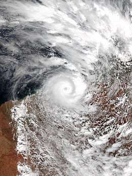 Cyclone Kelvin during its peak intensity over Western Australia on 18 February | |
| Formed | 11 February 2018 |
| Dissipated | 21 February 2018 |
| (Remnant low after 20 February) | |
| Highest winds | 10-minute sustained: 150 km/h (90 mph) 1-minute sustained: 150 km/h (90 mph) |
| Lowest pressure | 955 hPa (mbar); 28.2 inHg |
| Fatalities | None |
| Damage | $25 million (USD) |
| Areas affected | Northern Territory, Western Australia, South Australia |
| Part of the 2017–18 Australian region cyclone season | |
Kelvin brought widespread heavy rainfall to the Kimberley region which had already been saturated by other tropical cyclone systems. As a result, significant flooding occurred in parts of the Kimberley, including in the towns of Broome and Bidyadanga. Property damage was sustained at Broome and Anna Plains Station, where the cyclone made landfall, as well as infrastructural damage to the Great Northern Highway as a result of the heavy rainfall and flooding.
Meteorological history
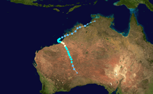
During the morning of 11 February, the Bureau of Meteorology (BOM) identified a developing tropical low pressure system near the Tiwi Islands, off the northwest coast of the Northern Territory.[1] During the following days, Tropical Low 17U tracked along a general west-southwesterly course over land while gradually intensifying.[1] As the system approached the coast, the BOM began issuing warnings, and forecast the low to potentially strengthen to a category 3 severe tropical cyclone in the coming days. The Joint Typhoon Warning Center (JTWC) also issued a tropical cyclone formation alert around this time. The system emerged over the Indian Ocean at about 8:00 am AWST on 16 February, but contrary to previous forecasts was generally slow to develop.[1]
The JTWC assessed the system as having attained one-minute sustained winds of 65 km/h (40 mph) twelve hours later, and hence upgraded it to Tropical Storm 10S at 12:00 UTC.[2] The system continued to slowly strengthen, and was upgraded to a category 1 tropical cyclone by the BOM at 2:00 pm local time on the following day, and was named Kelvin.[1] Tropical Cyclone Kelvin's movement speed slowed considerably at this stage, and it proceeded to turn sharply to the east. As the system approached the coast, the period of rapid intensification that had been forecast finally eventuated.[1] This intensification, fuelled by warm sea surface temperatures and very favourable atmospheric conditions, and compounded by the small size of the system, continued until landfall.
The cyclone crossed the coast near Anna Plains Station along Eighty Mile Beach at 00:00 UTC on 18 February as a category 3 severe tropical cyclone on the Australian scale with 10-minute sustained winds of 150 km/h (90 mph), and a central barometric pressure of 955 hPa (28.20 inHg).[1] The JTWC assessed the system as a high-end category 1 hurricane-equivalent cyclone on the Saffir-Simpson scale, with one-minute sustained winds of 150 km/h (90 mph), and a central barometric pressure of 963 hPa (28.44 inHg).[2] After making landfall, Tropical Cyclone Kelvin turned to the south-southeast, and began to track inland over the Kimberley region of Western Australia.[1] Despite losing the ocean as its primary source of energy, the cyclone was slow to weaken, partially due to the flat nature of the terrain and possibly also as a result of the brown ocean effect.[3]
The system was only downgraded below tropical cyclone intensity by the BOM after approximately 30 hours over the flat desert of Western Australia, at 2:00 pm AWST on 19 February.[1] Gale-force winds did persist in the southeastern quadrant, however, due to the influence of a high-pressure ridge to the southeast of the system. Unlike the BOM, The JTWC maintained the system's classification as a tropical storm for another 36 hours after this, only downgrading it to a tropical depression at 18:00 UTC on 20 February.[2] The remnants of the system continued to track south-southeastwards across the Great Sandy, Gibson and Great Victoria Deserts before emerging over the Great Australian Bight.[4]
Impacts
Severe Tropical Cyclone Kelvin and its precursor tropical low brought widespread heavy rainfall to the regions of Western Australia across which it tracked. These parts of Australia had already experienced record rainfall totals prior to the arrival of the system, with significant amounts being delivered by Tropical Cyclone Hilda,[5] Tropical Cyclone Joyce,[6] and Tropical Low 11U.[7] Broome Airport received 376.8 mm (14.8 in) of precipitation in the 24 hours prior to 9:00 am on 17 February, while West Roebuck received 370.0 mm (14.6 in) during this time.[1] The rain delivered by Tropical Cyclone Kelvin led Broome to record a record annual rainfall total of 1506.0 mm (59.3 in) by 9:00 am on 19 February, despite being less than two months into the calendar year.[1] The heavy rainfall caused the already saturated water catchments in the region to overflow, and significant flooding ensued in areas such as Broome, Kalumburu and along the Great Northern Highway.[1]
Property damage was reported at Anna Plains Station, where the cyclone made landfall, as well as minor damage in Broome.[1] Infrastructural damage in excess of A$16 million (US$12.7 million) also occurred along the Great Northern Highway due to the heavy rainfall and flooding,[8][9] causing some parts of the highway to be closed and cutting off several towns in the Kimberley region for some time.[10] In addition to the heavy precipitation, Tropical Cyclone Kelvin also generated a 0.5 metre (1.6 foot) storm surge at Broome Port.[1]
References
- "Tropical Cyclone Kelvin Impacts". www.bom.gov.au. Retrieved 21 February 2018.
- "Tropical Cyclone Kelvin Track File (JTWC)".
- "Northern Australia's inland ocean is fuelling cyclones and creating 'landphoons'". ABC News. 21 February 2018. Retrieved 21 February 2018.
- "Analysis Chart Archive". www.bom.gov.au. Retrieved 21 February 2018.
- Tropical Cyclone Hilda (Report). Australian Bureau of Meteorology. January 2018. Archived from the original on 17 January 2018. Retrieved 17 January 2018.
- "Tropical Cyclone Joyce Impacts". www.bom.gov.au. Retrieved 21 February 2018.
- "Tropical Low 11U Severe Weather Report 2018" (PDF).
- "Kimberley flooding leaves $16 million road repair bill after two cyclones - ABC News (Australian Broadcasting Corporation)". abc.net.au. Retrieved 19 March 2018.
- "Worse to come from 'abnormal' cyclone season with fears severe weather will return". ABC News. 21 February 2018. Retrieved 22 February 2018.
- Moore, Sophie (19 February 2018). "Tropical Cyclone Kelvin downgraded to low". The Weekly Times. Retrieved 27 February 2018.
External links
| Wikimedia Commons has media related to Cyclone Kelvin. |
Tropical cyclones of the 2017–18 Australian region cyclone season | ||
|---|---|---|
 | ||
| ||
| Politics and elections |
|
|---|---|
| People and culture | |
| Sports competitions | |
| Establishments and developments | |
| Disasters | |
| |