Culemborg
Culemborg (Dutch pronunciation: [ˈkyləmbɔrx] (![]()
Culemborg | |
|---|---|
City and municipality | |
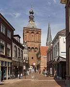
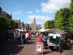 Culemborg market square | |
 Flag  Coat of arms | |
.svg.png) Location in Gelderland | |
| Coordinates: 51°57′N 5°14′E | |
| Country | Netherlands |
| Province | Gelderland |
| Government | |
| • Body | Municipal council |
| • Mayor | Gerdo van Grootheest (GL) |
| Area | |
| • Total | 31.14 km2 (12.02 sq mi) |
| • Land | 29.42 km2 (11.36 sq mi) |
| • Water | 1.72 km2 (0.66 sq mi) |
| Elevation | 5 m (16 ft) |
| Population (January 2019)[4] | |
| • Total | 28,555 |
| • Density | 971/km2 (2,510/sq mi) |
| Demonym(s) | Culemborger, Blauwlap |
| Time zone | UTC+1 (CET) |
| • Summer (DST) | UTC+2 (CEST) |
| Postcode | 4100–4107 |
| Area code | 0345 |
| Website | www |
History
Culemborg, formerly also spelled Kuilenburg or Kuylenburgh, received city rights in 1318. For a long time, Culemborg was independent from any counties or duchies in the Netherlands. The city had gained the right of toll collection and the right of asylum: it was a so-called 'Vrijstad' (free city). In practice, this meant that people who had fled to Culemborg from other cities (for example due to bankruptcy) could evade their creditors in Culemborg. The creditors would not be allowed entry into the city. This did not mean that criminals could escape justice in Culemborg: the city had its own justice system which could sentence criminals. In Amsterdam, the phrase 'Naar Culemborg gaan' (Going to Culemborg) became synonymous with going bankrupt.
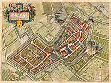
In Joan Blaeu's map of 1649, Culemborg remains entirely enclosed by walls behind its city moat-like encircling canals. The moated castle stands outside the city walls. Houses present a united front along streets and the two canals that cut the city in three sections, but they all face gardens behind, and market gardens are plentiful within the city walls.
In the beginning of the 18th century, Culemborg effectively lost its independence as it was incorporated into the Nijmegen Quarter, although it regained some sovereign rights. Later, it was gifted to stadholder Willem IV. To this day, the Dutch king Willem-Alexander remains count of Culemborg. In 1795, the city was occupied by French forces, who left the castle in such a despicable state it was demolished after the French had left. A few years later it was completely incorporated in the Bataafse Republiek, and losing its sovereign rights.
In 1868, a railway bridge was built over the river Lek which was the longest bridge in Europe for a few years.
In 1995, Culemborg was one of the cities which was temporarily evacuated because of the risk of flooding.
Between 1994 and 2009 the city of Culemborg developed the innovative ecological neighbourhood EVA Lanxmeer. Close collaboration with inhabitants and experimental sustainable design has made the neighbourhood an international best practice.
Transportation
Culemborg is served by Culemborg railway station, which offers trains to Utrecht (city) 4x per hour and 2x per hour to 's-Hertogenbosch and Tiel each. The railway station also provides a bus hub, offering buses to the various neighbouring cities and villages (namely Buren, Beusichem and Nieuwegein).
Topography
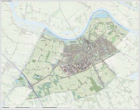
Dutch topographic map of the municipality of Culemborg, June 2015
Economy
Dough processing company Rademaker BV, founded in 1977, moved to Culemborg in 1981 and still has their headquarters here.
Windmills
There are two traditional windmills in Culemborg, De Hoop and Johanna. The base of a third mill, De Koornvriend, also survives.[6]
Notable residents
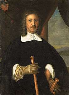
- Anthony van Diemen (1593–1645), Governor-General of the Dutch East Indies[7]
- Jan van Riebeeck (1619–1677), colonial administrator and founder of Cape Town (South Africa)
- Roelof de Man (1634 - 1663), bookkeeper and second-in-charge to Jan van Riebeeck at founding of Cape Town (South Africa)
- Otto van Rees (1823–1892), minister and Governor-General of the Dutch East Indies
- Rudi Martinus van Dijk (1932–2003) a Dutch and Canadian composer of orchestral, chamber and vocal music
- Wilhelmina Cooper (1939–1980), fashion model and founder of Wilhelmina Models, New York
- Jelka van Houten (born 1978), actress[8]
Sport
- Elly van Hulst (born 1959), middle distance runner, competed at the 1984 and 1988 Summer Olympics
- Patrick Pothuizen (born 1972), football player over 450 club caps
- Michiel Elijzen (born 1982) a Dutch former professional road bicycle racer
Gallery
 Town gate: de Binnenpoort
 Culemborg, 1880
 Windmill: molen de Hoop
.jpg) Culemborg - panorama
Culemborg - panorama
References
- "Burgemeester Van Schelven" [Mayor Van Schelven] (in Dutch). Gemeente Culemborg. Archived from the original on 14 July 2014. Retrieved 23 June 2014.
- "Kerncijfers wijken en buurten" [Key figures for neighbourhoods]. CBS Statline (in Dutch). CBS. 2 July 2013. Retrieved 12 March 2014.
- "Postcodetool for 4101BK". Actueel Hoogtebestand Nederland (in Dutch). Het Waterschapshuis. Retrieved 23 June 2014.
- "Bevolkingsontwikkeling; regio per maand" [Population growth; regions per month]. CBS Statline (in Dutch). CBS. 1 January 2019. Retrieved 1 January 2019.
- "Bevolkingsontwikkeling; regio per maand" [Population growth; regions per month]. CBS Statline (in Dutch). CBS. 1 January 2019. Retrieved 1 January 2019.
- "De Koornvriend, Culemborg" (in Dutch). Molendatabase. Retrieved 6 November 2014.
- 1911 Encyclopædia Britannica, Volume 8, Diemen, Anthony van retrieved 27 December 2019
- IMDb Database retrieved 27 December 2019
External links

- (in Dutch) Official website
Places adjacent to Culemborg | ||||||||||
|---|---|---|---|---|---|---|---|---|---|---|
| ||||||||||

| Authority control |
|
|---|