Outer Continental Shelf
The Outer Continental Shelf (OCS) is a peculiarity of the political geography of the United States. The OCS is the part of the internationally recognized continental shelf of the United States which does not fall under the jurisdictions of the individual U.S. states.
Definition
Formally, the OCS is governed by Title 43, Chapter 29 "Submerged Lands", Subchapter III "Outer Continental Shelf Lands", of the U.S. Code. The term "outer Continental Shelf" refers to all submerged land, its subsoil and seabed that belong to the United States and are lying seaward and outside the states' jurisdiction, the latter defined as the "lands beneath navigable waters" in Title 43, Chapter 29, Subchapter I, Section 1301.[1]
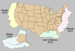
The United States OCS has been divided into four leasing regions:[2]
- Gulf of Mexico OCS Region
- Atlantic OCS Region
- Pacific OCS Region
- Alaska OCS Region
State jurisdiction is defined as follows:[2]
- Texas and the Gulf coast of Florida are extended 3 marine leagues (approximately 9 nautical miles) seaward from the baseline from which the breadth of the territorial sea is measured.
- Louisiana is extended 3 (pre-1954 U.S.) nautical miles (5.560 km; 3.455 mi) seaward[3] of the baseline from which the breadth of the territorial sea is measured (as defined pre-1954 in the U.S.: nautical mile = 6080.2 feet).
- All other States' seaward limits are extended 3 international nautical miles (5.556 km; 3.452 mi) seaward of the baseline from which the breadth of the territorial sea is measured.
Federal jurisdiction is defined under accepted principles of public international law. The seaward limit is defined as the farthest of 200 nautical miles (370.4 km; 230.2 mi) seaward of the baseline from which the breadth of the territorial sea is measured or, if the continental shelf can be shown to exceed 200 nautical miles, a distance not greater than a line 100 nautical miles from the 2,500-meter (8,200 ft) isobath or a line 350 nautical miles (648.2 km; 402.8 mi) from the baseline.[2]
Outer Continental Shelf limits greater than 200 nautical miles but less than either the 2,500-meter isobath plus 100 nmi or 350 nmi are defined by a line 60 nautical miles (111.1 km; 69.0 mi) seaward of the foot of the continental slope or by a line seaward of the foot of the continental slope connecting points where the sediment thickness divided by the distance to the foot of the slope equals 0.01, whichever is farthest.[2]
Coastlines are emergent coastline. Thus the landward boundary of the outer continental shelf is a legal construct rather than a physical construct, modified only at intervals by appropriate processes of law.
For legislation concerning the OCS, the United States Senate Committee on Commerce, Science & Transportation has jurisdiction within the United States Senate.[4] In the House of Representatives, the Committee on Natural Resources Subcommittee on Energy and Mineral Resources has jurisdiction over administration and legislation amending the OCSLA. One of the main pieces of legislature affecting the OCS is the Outer Continental Shelf Lands Act (OCSLA), created on August 7, 1953, which defined the OCS as all submerged lands lying seaward of state coastal waters (3 miles offshore) under U.S. jurisdiction; under the OCSLA, the Secretary of the Interior is responsible for the administration of mineral exploration and development of the OCS. The OCSLA has been amended several times, most recently as a result of the Energy Policy Act of 2005.[5]
After Congress passed the Federal Oil and Gas Royalty Management Act in 1982, the Secretary of the Interior designated the Minerals Management Service (MMS) as the administrative agency responsible for the mineral leasing of submerged OCS lands and for the supervision of offshore operations; in 2010 MMS was renamed the Bureau of Ocean Energy Management, Regulation and Enforcement (BOEMRE).[5] On October 1, 2011, BOEMRE was divided into two bureaus, the Bureau of Safety and Environmental Enforcement (BSEE) and the Bureau of Ocean Energy Management (BOEM). BSEE is the agency charged to provide regulatory oversight of deepwater oil drilling and offshore wind energy sources in U.S. Federal waters that extend beyond State jurisdiction.[6]
See also
References
- "43 U.S. Code Chapter 29 - SUBMERGED LANDS". cornell.edu. Archived from the original on 2011-11-14.
- "The Bureau of Ocean Energy Management, Regulation and Enforcement HomePage". mms.gov. Archived from the original on 2007-11-20.
- Rivet, Ryan (June 2008). "Petroleum Dynamite". Tulanian. pp. 20–27. Archived from the original on 13 June 2010. Retrieved 7 Sep 2009.
Under its original acquisition terms with the federal government in 1803, Louisiana’s mineral rights extended out for only three miles. When [the Federal government was] approached by the [Louisiana governor Earl] Long administration [in 1948], the federal government said it was willing to discuss a compromise and split of the royalties in the area beyond three miles. ... [Ultimately,] Truman [said no].
- http://commerce.senate.gov/public/index.cfm?FuseAction=About.Jurisdiction Archived 2008-09-15 at the Wayback Machine U.S. Senate Committee on Commerce, Science & Transportation
- "OCS Lands Act History". boem.gov. Archived from the original on 2013-05-03.
- Who is the Minerals Management Service? Archived 2010-06-03 at the Wayback Machine, U.S. Department of the Interior, accessed 2010-06-13.