Colombières
Colombières is a commune in the Calvados department in the Normandy region in northwestern France.
Colombières | |
|---|---|
 | |
Location of Colombières 
| |
 Colombières  Colombières | |
| Coordinates: 49°17′49″N 0°58′48″W | |
| Country | France |
| Region | Normandy |
| Department | Calvados |
| Arrondissement | Bayeux |
| Canton | Trévières |
| Intercommunality | CC Isigny-Omaha Intercom |
| Government | |
| • Mayor (2008–2014) | Claude Lemonnier |
| Area 1 | 10.64 km2 (4.11 sq mi) |
| Population (2017-01-01)[1] | 210 |
| • Density | 20/km2 (51/sq mi) |
| Time zone | UTC+01:00 (CET) |
| • Summer (DST) | UTC+02:00 (CEST) |
| INSEE/Postal code | 14168 /14710 |
| Elevation | 0–33 m (0–108 ft) (avg. 15 m or 49 ft) |
| 1 French Land Register data, which excludes lakes, ponds, glaciers > 1 km2 (0.386 sq mi or 247 acres) and river estuaries. | |
Geography
Colombières is situated in the north-western region of Calvados, 20 kilometres west of Bayeux and 9 kilometres from Isigny-sur-Mer, in the natural regional park of Cotentin and Bessin.
History
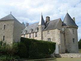
The village was freed on 9 June 1944 by the Allies. U.S. General Omar Bradley set up base for the Twelfth United States Army Group in Colombières castle.
Places of interest
Colombières castle is a historic building, built between Bayeux and Isigny-sur-Mer, close to the D-Day landing beaches. It was one of the most famous forts in Lower Normandy while France was under Feudal rule. It is also known as : La vigie des Marais (The marsh lookout).
Population
| Historical population | ||
|---|---|---|
| Year | Pop. | ±% |
| 1962 | 362 | — |
| 1968 | 306 | −15.5% |
| 1975 | 231 | −24.5% |
| 1982 | 247 | +6.9% |
| 1990 | 218 | −11.7% |
| 1999 | 225 | +3.2% |
| 2008 | 198 | −12.0% |
See also
External links
| Wikimedia Commons has media related to Colombières. |
| Authority control |
|
|---|
This article is issued from Wikipedia. The text is licensed under Creative Commons - Attribution - Sharealike. Additional terms may apply for the media files.