Amayé-sur-Seulles
Amayé-sur-Seulles is a commune in the Calvados department in the Normandy region of northwestern France.
Amayé-sur-Seulles | |
|---|---|
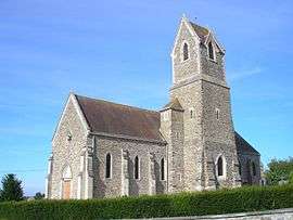 The church in Amayé-sur-Seulles | |
_Calvados-France.svg.png) Coat of arms | |
Location of Amayé-sur-Seulles 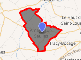
| |
 Amayé-sur-Seulles  Amayé-sur-Seulles | |
| Coordinates: 49°04′51″N 0°42′47″W | |
| Country | France |
| Region | Normandy |
| Department | Calvados |
| Arrondissement | Vire |
| Canton | Aunay-sur-Odon |
| Intercommunality | Pré-Bocage Intercom |
| Government | |
| • Mayor (2014-2020) | Pascal Cotard |
| Area 1 | 5.62 km2 (2.17 sq mi) |
| Population (2017-01-01)[1] | 230 |
| • Density | 41/km2 (110/sq mi) |
| Time zone | UTC+01:00 (CET) |
| • Summer (DST) | UTC+02:00 (CEST) |
| INSEE/Postal code | 14007 /14310 |
| Elevation | 91–194 m (299–636 ft) (avg. 160 m or 520 ft) |
| 1 French Land Register data, which excludes lakes, ponds, glaciers > 1 km2 (0.386 sq mi or 247 acres) and river estuaries. | |
The inhabitants of the commune are known as Amayéens or Amayéennes[2]
Geography
Amayé-sur-Seulles is located four kilometres west of Villers-Bocage and 20 kilometres south of Bayeux in the Seulles valley. It can be accessed by road D71 coming west from Villers-Bocage through the heart of the commune and village and continuing west to Caumont-l'Evente. The road D193 running west from Cahagnes to Villers-Bocage forms the southern boundary of the commune. The road D215 also starts from the hamlet of Saint-German in the commune and runs south-west to Tracy-Bocage. There are also many small country roads in the commune. In addition to the village there are also the hamlets of Saint-German to the east and La Vallee to the north of the village. The commune consists entirely of farmland.[3]
La Seulles river passes through the northern part of the commune and Le Calichon which forms the northern boundary of the commune flows into it. Another stream which rises near the village flows north forming part of the eastern boundary of the commune and also joins La Seulles. In the south-east the Ruisseau du Caudray forms the south-eastern boundary of the commune and flows eastwards to join La Seulline river. The Ruisseau de Pont Chouquet flows into the Caudray and forms part of the eastern boundary of the commune.[3]
Neighbouring communes and villages[3] | ||||||||||
|---|---|---|---|---|---|---|---|---|---|---|
| ||||||||||
Heraldry
Arms of Amayé-sur-Seulles |
Blazon: Vert, 3 fesses wavy of argent between 3 cinquefoils of Or 2 and 1.. |
Administration
List of Successive Mayors of Amayé-sur-Seulles[4]
| From | To | Name | Party | Position |
|---|---|---|---|---|
| 1983 | 2001 | Charles Guilbert | SE | Farmer |
| 2001 | Current | Pascal Cotard | SE | Farmer |
(Not all data is known)
Population
| Historical population | ||
|---|---|---|
| Year | Pop. | ±% |
| 2006 | 195 | — |
| 2007 | 190 | −2.6% |
| 2008 | 203 | +6.8% |
| 2009 | 202 | −0.5% |
| 2010 | 200 | −1.0% |
| 2011 | 199 | −0.5% |
| 2012 | 199 | +0.0% |
| 2013 | 200 | +0.5% |
| 2014 | 209 | +4.5% |
| 2015 | 218 | +4.3% |
| 2016 | 227 | +4.1% |
Sites and Monuments
- The Church of Saint-Vigor (15th century) belonged to the Abbey of Cerisy. It contains two items which are registered as historical objects:
- The Chateau of Bosq (18th century)
- The Clos d'Orval cider farm with an exhibition of old cider-making equipment.[7]
See also
External links
- Amayé-sur-Seulles on the old National Geographic Institute website (in French)
- Amayé-sur-Seulles on Lion1906
- Amayé-sur-Seulles on Google Maps
- Amayé-sur-Seulles on Géoportail, National Geographic Institute (IGN) website (in French)
- Amayé on the 1750 Cassini Map
- Amayé-sur-Seulles on the INSEE website (in French)
- INSEE (in French)
Notes and references
Notes
References
- "Populations légales 2017". INSEE. Retrieved 6 January 2020.
- Inhabitants of Calvados (in French)
- Google Maps
- List of Mayors of France (in French)
- Ministry of Culture, Palissy PM14001050 Statue: Virgin and child (in French)
- Ministry of Culture, Palissy PM14000003 Retable: Virgin and child (in French)

- Interprofession des appellations cidricoles website - the Clos d'Orval
| Wikimedia Commons has media related to Amayé-sur-Seulles. |
| Authority control |
|
|---|