Cambremer
Cambremer is a commune in the Calvados department in the Normandy region in northwestern France. Cambremer is located in the heart of the Pays d'Auge, between Lisieux and Caen.
Cambremer | |
|---|---|
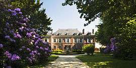 Chateau Les Bruyères | |
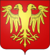 Coat of arms | |
Location of Cambremer 
| |
 Cambremer  Cambremer | |
| Coordinates: 49°09′10″N 0°02′54″E | |
| Country | France |
| Region | Normandy |
| Department | Calvados |
| Arrondissement | Lisieux |
| Canton | Mézidon-Canon |
| Intercommunality | CA Lisieux Normandie |
| Government | |
| • Mayor (2014–2020) | Annick Sevestre |
| Area 1 | 27.05 km2 (10.44 sq mi) |
| Population (2017-01-01)[1] | 1,359 |
| • Density | 50/km2 (130/sq mi) |
| Time zone | UTC+01:00 (CET) |
| • Summer (DST) | UTC+02:00 (CEST) |
| INSEE/Postal code | 14126 /14340 |
| Elevation | 20–162 m (66–531 ft) (avg. 96 m or 315 ft) |
| 1 French Land Register data, which excludes lakes, ponds, glaciers > 1 km2 (0.386 sq mi or 247 acres) and river estuaries. | |
Etymology
We do not know the exact etymology of the name of the town. The village is mentioned, however, from the seventh century under the Latinized form of Cambrimaro.
The second element is probably the Germanic meaning lake or pond (see Old English meri: lake, pond, now in place names -Mère). Common in the north of France (see Mortemer ).
History
In 1972, the commune of Grandouet in the canton of Cambremer and those of Saint-Aubin-sur-Algot and Saint-Pair-du-Mont, in the township of Mézidon-Canon, were incorporated in Cambremer. On 1 January 2019, the former commune of Saint-Laurent-du-Mont was merged into Cambremer.[2]
Heraldry
The arms of the town of Cambremer are: Gules the two-headed eagle displayed gold.
Population
| Historical population | ||
|---|---|---|
| Year | Pop. | ±% |
| 1962 | 1,191 | — |
| 1968 | 1,068 | −10.3% |
| 1975 | 936 | −12.4% |
| 1982 | 915 | −2.2% |
| 1990 | 1,006 | +9.9% |
| 1999 | 1,092 | +8.5% |
| 2008 | 1,096 | +0.4% |
See also
References
- "Populations légales 2017". INSEE. Retrieved 6 January 2020.
- Arrêté préfectoral 24 September 2018, p. 119 (in French)
| Wikimedia Commons has media related to Cambremer. |
| Authority control |
|
|---|