Sainshand
Sainshand (Mongolian: Сайншанд; ᠰᠠᠶᠢᠨᠱᠠᠩᠳᠠ) is the capital of Dornogovi Province in Mongolia. It is located in the eastern Gobi desert steppe, on the Trans-Mongolian Railway.
Sainshand District Сайншанд сум ᠰᠠᠶᠢᠨᠱᠠᠩᠳᠠᠰᠤᠮᠤ | |
|---|---|
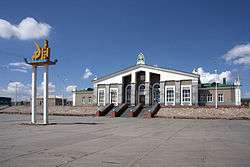 The train station in Sainshand | |
 Sainshand District | |
| Coordinates: 44°53′30″N 110°8′12″E | |
| Country | Mongolia |
| Province | Dornogovi Province |
| Founded | 1931 |
| Area | |
| • Total | 2,300 km2 (900 sq mi) |
| Elevation | 961 m (3,153 ft) |
| Population (2017) | |
| • Total | 24,772 |
| • Density | 11/km2 (28/sq mi) |
| Time zone | UTC+8 (UTC + 8) |
| Area code(s) | (+976) 1522 |
Administration
The territory of Sainshand sum consists of 5 bags (communes). The first three bags make up the main part of the city, Övör (Southern), the fourth bag is the Ar (Northern) part, and the fifth bag is the remote oil production settlement Züünbayan, 46 kilometres (29 mi) south from the main part of the city.
Geography
The northern and southern parts are divided by a range of hills. The main Dornogovi Province institutions are located in the southern part of the city.
Population
The city has a population of 25,210 (2000 census), 19,548 (2006, est.[1]), 19,891(2008, est.[2]).
The population of the northern part was 4,944 at the end of 2006[1] and 4,822 at the end of 2008.[2] The population of the southern part was 12,687 at the end of 2006[1] and 13,463 at the end of 2008.[2]
Sights
The restored Buddhist monastery Khamariin Khiid (Khamar) is 30 kilometres (19 mi) south of the city and Sainshand itself. It houses a museum dedicated to the 19th century monastic and literary figure Danzanravjaa, a prominent leader of the Nyingma (Red Hat) school of Tibetan Buddhism.
Climate
Sainshand experiences a desert climate (Köppen BWk) with long, very dry, very cold winters and short, hot summers.
| Climate data for Sainshand | |||||||||||||
|---|---|---|---|---|---|---|---|---|---|---|---|---|---|
| Month | Jan | Feb | Mar | Apr | May | Jun | Jul | Aug | Sep | Oct | Nov | Dec | Year |
| Record high °C (°F) | 1.1 (34.0) |
13.1 (55.6) |
21.6 (70.9) |
29.4 (84.9) |
36.7 (98.1) |
40.0 (104.0) |
39.5 (103.1) |
38.4 (101.1) |
32.6 (90.7) |
26.6 (79.9) |
14.3 (57.7) |
6.2 (43.2) |
40.0 (104.0) |
| Average high °C (°F) | −11.8 (10.8) |
−6.7 (19.9) |
3.0 (37.4) |
14.1 (57.4) |
22.5 (72.5) |
27.5 (81.5) |
29.4 (84.9) |
27.5 (81.5) |
20.8 (69.4) |
12.0 (53.6) |
−0.6 (30.9) |
−9.8 (14.4) |
10.7 (51.2) |
| Daily mean °C (°F) | −18.1 (−0.6) |
−13.7 (7.3) |
−4.2 (24.4) |
5.9 (42.6) |
14.5 (58.1) |
20.4 (68.7) |
22.7 (72.9) |
20.9 (69.6) |
13.6 (56.5) |
4.4 (39.9) |
−7.0 (19.4) |
−15.6 (3.9) |
3.6 (38.6) |
| Average low °C (°F) | −22.8 (−9.0) |
−19.5 (−3.1) |
−10.9 (12.4) |
−1.1 (30.0) |
7.2 (45.0) |
13.6 (56.5) |
16.8 (62.2) |
15.0 (59.0) |
7.5 (45.5) |
−1.4 (29.5) |
−12.3 (9.9) |
−20.4 (−4.7) |
−2.4 (27.8) |
| Record low °C (°F) | −35 (−31) |
−35.8 (−32.4) |
−27.1 (−16.8) |
−22.6 (−8.7) |
−10.2 (13.6) |
3.2 (37.8) |
7.2 (45.0) |
5.6 (42.1) |
−4.4 (24.1) |
−17.1 (1.2) |
−28 (−18) |
−34.3 (−29.7) |
−35.8 (−32.4) |
| Average precipitation mm (inches) | 0.5 (0.02) |
1.1 (0.04) |
1.5 (0.06) |
3.1 (0.12) |
8.1 (0.32) |
16.1 (0.63) |
31.0 (1.22) |
30.9 (1.22) |
10.9 (0.43) |
4.6 (0.18) |
2.1 (0.08) |
1.4 (0.06) |
111.3 (4.38) |
| Average precipitation days (≥ 1.0 mm) | 0.1 | 0.3 | 0.4 | 0.7 | 1.6 | 2.8 | 5.4 | 4.4 | 1.8 | 1.0 | 0.6 | 0.4 | 19.5 |
| Source: NOAA (1961-1990) [3] | |||||||||||||
Transport
The railway station on the Trans-Mongolian Railway is found in the northern part. A 7 kilometres (4.3 mi) long section to the west contains the ruins of an abandoned Soviet military base.
See also
References
External links
| Wikimedia Commons has media related to Sainshand. |
| Wikivoyage has a travel guide for Sainshand. |
 | ||
Capital: Ulaanbaatar | ||
| ||