Chitwan District
Chitwan District (/ˈtʃɪtəˌwʌn/, Nepali: चितवन, pronounced [ˈtsitwʌn] ![]()
Chitwan चितवन | |
|---|---|
District | |
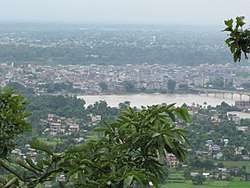 Narayangarh city view from Maula Kalika temple Gaindakot | |
| Motto(s): हाम्रो चितवन, राम्रो चितवन | |
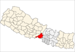
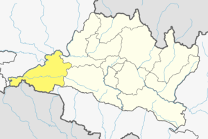 Location in Bagmati Pradesh | |
| Coordinates: 27°35′N 84°30′E | |
| Country | Nepal |
| Province | Bagmati Pradesh |
| Headquarters | Bharatpur |
| HDI | |
| HPI | |
| Established | 14th century[2] |
| Area | |
| • Total | 2,238.39 km2 (864.25 sq mi) |
| Elevation | 415 m (1,362 ft) |
| Population (2014) | |
| • Total | 579,984[3] |
| • Ethnicities | Brahmin, Chhetri, Tharu, Newar, Darai, Gurung, Magars, Tamang, Chepang Pariyar |
| • Religions | Hindu, Buddhist, Christian |
| Languages | |
| • Local | Nepali, Tharu, Newari, Tamang, Gurung, Darai, Magar, Chepang |
| • Official | Nepali |
| Time zone | UTC+5:45 (Nepal Time) |
| Area code(s) | 056 |
| Website | www.ddcchitwan.gov.np |
History
The district takes its name from the Chitwan Valley, one of Nepal's Inner Terai valleys between the Mahabharat and Siwalik ranges, both considered foothills of the Himalayas.
Narayangadh is located on the banks of the Narayani River, and is the main town with numerous shopping zones where people come from all over the district and neighbouring districts. Over 24 languages is spoken at this area.
Chitwan is one of the few remaining undisturbed vestiges of the Terai region, which formerly extended over the foothills of Nepal.
Origin
There are several predication on the origin of the name Chitwan. Some of the most satisfactory predications on the origin of its name are:
- The name Chitwan is a composite of the Sanskrit words चित्त, transliterated "citta" meaning heart and वन, transliterated "vana" meaning jungle or forest.[4][5] Thus, the meaning of Chitwan is Heart of the Jungle.
- Chitwan was a dense forest ruled by the Tharu God/King Chitrasen Baba. He used to worship in the deep forest and ruled over his state. People believe him as the incarnation of Lord Vishnu. Still today, Tharu people worship his idol during HariBodhini Ekadashi in Chitrasari (Headquarters of Chitrasen Baba), way to Sauraha. Since the forest locally called ban (वन) was ruled by Lord Chitrasen, it was called Chitra Ban, later transliterated to Chitwan.
- Chitwan, still known as Dense Forest was a land of leopard and Bengal tiger. Leopard is locally called चित्रि according to Tharu language. Since the forest (वन) was densely populated by leopard or चित्रि, it was called the forest of leopard, namely चित्रि वन (Chitri Ban), later transliterated to Chitwan.
- Chitwan is the home land of Tharu people, who are renowned for their art and drawing. Their houses are decorated by religious drawings denoting different phases of history, culture and environment along that time. Since their homes in the forest were decorated with their drawings, locally called चित्र, the land was called चित्र वन (Chitra Ban), later transliterated to Chitwan.
Chitwan was originally a dense forest ruled by Chitrsen Baba, where different RishiMunis came to have their meditation during ancient time with numbers of wild animals like leopard and Bengal tiger. .
Agriculture and industry
The people inhabiting the Chitwan District are predominantly peasant farmers cultivating mainly food and cash crops such as rice, maize, wheat, beans, lentils, mustard and Vegetables. The district is the major maize-producing area in Nepal, with an area under maize cultivation of 27,170 ha (104.9 sq mi) in the year 2003–04. Maize is cultivated on irrigated /seasonal irrigated land in winter and spring, and on rain fed land in summer. Due to an easy road access, maize produced can be easily distributed to other parts of the country. The poultry industry in the district constitutes a significant proportion of the country's poultry industry.[6]
Chitwan is famous in Nepal for mustard growing and production of mustard oil. This popularity of the mustard in Chitwan is attributed to the predominant soil type silt, resulting from the flooding of the Narayani River and tributaries. Chitwan is also profusely spotted with clay lands, which are very good for growing rice, wheat and vegetables such as cabbage, cauliflower, radish, potato, broccoli, cucumbers, pumpkins, and carrot. Chitwan is also famous for floriculture, mushroom cultivation and bee keeping. Terai is the kitchen of Nepal. Chitwan is also famous for sweet potato and cauliflower production.
At present Bharatpur's largest business area, Narayangadh, is less accessible due to the movement of the main bus terminal due to the previous king's son's anger with the politics of the citizens of the city. This bus terminal is however no longer in use following a successful people's movement in 2006. It is believed that Nepali leftist revolutionary leader Prachanda spent his childhood and youth in Chitwan. Chitwan is adapting the New Community Movement South Korean model of development. One of the biggest rice mills, Agam Food Industry, is situated in Bharatpur-13, Chitwan. This industry process rice into various forms also employing many local people. Chitwan is very fresh and good place to live in.
Cuisine
Chitwan is very popular for tasty Taas (Nepali: तास), a spicy fried goat meat dish served with bhuja or cheura available in many restaurants. Momo, sukuti Khaja Set and other Newari cuisine and Tharu food and Bhuteko Bhat is also popular. Dal bhat is the staple food of the area, meat and dairy products are also widely consumed. For centuries, traditional fermented foods and beverages have constituted about 20% of the local diet. Depending on altitudinal variation, finger millet, wheat, buckwheat, barley, vegetable, rice, potato, and soybeans etc. are grown. Thakali Khana set is the best dinner in Chitwan which is mostly found in famous places like Sauraha, Tandi, Naryangadh, and Lilachowk.
Places of interest
| Chitwan National Park | |
|---|---|
IUCN category II (national park) | |
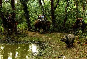 Elephant safari after an Indian rhinoceros |
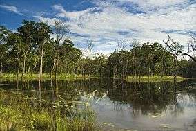 Beeshazar Lake near Chitwan National Park
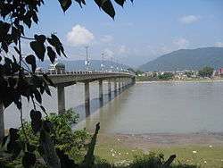 Narayani bridge in Narayangarh, Chitwan, Nepal
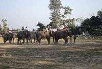 Elephant polo World cup 2012 in Meghauli, Nepal
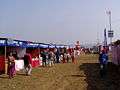 Chitwan Mahotsav 2063 (Chitwan Mahotsav 2007 A.D.) in Narayangarh, Chitwan
Chitwan has a particularly rich flora and fauna. Nepal's first national park, the Chitwan National Park together with the adjacent Parsa National Park support a species diversity much higher than any other on the Indian subcontinent. Rare species include Bengal tiger, gharial, rhino, leopards, mugger crocodile, Indian rock python and several species of deer. The protected areas are guarded by a battalion of the Nepal Army and patrolled by anti-poaching units.[7]
The Rapti River flows east to south west in the south of Bharatpur and forms the northern border of the Chitwan National Park. The Narayani River flows north to south in the west of Bharatpur. It is the deepest and also one of the biggest rivers of Nepal. The Narayani Bridge over the river connects Chitwan District with Nawalparasi District of Nepal. Small island, like Nagarban in Narayani river are popular picnic spot.
Bishazari Tal (20 Thousand) Lake is close by Chitwan National Park, about 5 km (3.1 mi) south of Bharatpur. The lake serves as an important bird watching centre and is attractive for bird lovers. It also harbours crocodiles.
Das Dhunga is a famous place in Chitwan. The people's leader Madan Bhandari was killed there in an accident.
Narayangarh is the main shopping area of Bharatpur city, and the main transit point for all the vehicles travelling via the east–west Mahendra Highway, also for the people travelling from Kathmandu, Gorkha, and Pokhara through Mugling. Recently, Narayangarh has become a retail and commercial capital of Chitwan District and Bharatpur Municipality. It is also the center for hospitality industry which includes hotels, lodges, restaurants and transportation hub for the district.
Upardangadhi, one of the historical basement (known as किल्ला) in Nepali), is also located here in saktikhor which is made by the grandson of well-known king of Nepal Prithivi Narayan Shaha, Bir Bikram Shaha.
Transportation and communication
_2.jpg)
Bharatpur Airport in the central part of the city offered four domestic airlines and one government airline with seven to 11 flights daily to Kathmandu. Mahendra East West Highway connects the city to various parts of the country, and another highway connects Bharatpur with Kathmandu to the north east and with Birgunj on the border of India to the south. Bus, micro bus and other land transportation are available to go out of the city, for internal transportation taxi, rickshaw and car/jeep hiring is available. Hakim Chowk and Chaubiskothi, Shaheed Chok, Pul Chowk, Bel Chowk and Lila Chowk are major centres at intersections of major roads. There are four major local FM radio stations broadcast in Bharatpur, such as Synergy FM,[8] Hamro FM, Radio Triveni, Radio Madi, Radio Chitwan,[9] Radio Kotagiri, Chitwan Online FM, Kalika Music FM, Kalika FM.[10] and Narayani FM. The city also has Beso Channel, "Aviyan Channel", Unique Television and Avass Television.
Land line telephone services and mobile telephone services are available to the majority of areas. There are multiple private Internet service providers. Major cities in chitwan are flourished with fibre connectivity and 4G internet.
Fort, Palace and landmark buildings
- Upardanghari fort is in the old headquarters of Chitwan district and is believed to be made by Satrubhanjan Shah, son of Prince Bahadur Shah to defend newly founded Kingdom in the 17th century. It is located on the top of a hill and overlooks a very nice natural scenery.
- Kasara Durbar (palace) is an old palace built by the Rana Regime inside Chitwan National Park. Now it is being used as an office of the national park and also hosts a museum
- Diyalo Bangala Palace (Aptari Bharatpur) was the spring season palace used by the Shah Dynasty of Nepal. This palace was built by late king Mahendra Bir Bikram Shahdev to rest in during winter season. It is located on the banks of Narayani River in Bharatpur Municipality ward no. 2.
- DAO Building Bharatpur: This old building was built in the period of shifting the headquarters from Upardangghari. Now is used as an office of the chief district officer.
- Bharatpur Covered hall: Hall in guesthouse of Bharatpur for indoor games.
Geography and climate
| Climate Zone[11] | Elevation Range | % of Area |
|---|---|---|
| Lower tropical | below 300 m (980 ft) | 58.2% |
| Upper tropical | 301 to 1,000 m (988 to 3,281 ft) | 32.6% |
| Subtropical | 1,001 to 2,000 m (3,284 to 6,562 ft) | 6.7% |
Major places
|
|
|
Demographics
At the time of the 2011 Nepal census, Chitwan District had a population of 579,984. Of these, 70.1% spoke Nepali, 10.2% Tharu, 4.9% Tamang, 3.7% Chepang, 2.8% Gurung, 1.7% Bhojpuri, 1.6% Magar, 1.6% Newari, 1.1% Darai, 0.6% Maithili and 0.5% Hindi as their first language.
27.3% of the population in the district spoke Nepali as their second language.[12]
Administration
The district consists of 7 Municipalities, out of which one is a Metropolitan city, five are urban municipalities and one is a rural municipalities. These are as follows:[13]
- Bharatpur Metropolitan City
- Kalika Municipality
- Khairahani Municipality
- Madi Municipality
- Ratnanagar municipality
- Rapti Municipality
- Ichchhakamana Rural Municipality
Former Municipalities and Gaunpalikas
Prior to the restructuring of the district, Chitwan had following Gaunpalika and municipalities.[14]

- Ayodhyapuri
- Bagauda
- Bharatpur Metropolitan
- Chandi Bhanjyang
- Dahakhani
- Gardi
- Kalika Municipality
- Kabilas
- Kathar
- Kaule
- Khairhani municipality
- Korak
- Lothar
- Madi Municipality
- Madi Kalyanpur
- Mangalpur
- Narayanpur
- Piple
- Ratnanagar municipality
- Rapti Municipality
- Siddi
Medical city and hospitals
Chitwan district is also known as the medical city of Nepal. There are many top rated medical institutions in the district, although most of them are situated in and around Bharatpur Municipality. People from all over Nepal and also from North India come here for treatment. The district is especially famous for the cancer hospital at Krishnapur named after B.P. Koirala. After Kathmandu, Biratnagar and Pokhara, it is the most medically sophisticated district of Nepal. Hospitals in the district comprise:
- Bharatpur Hospital Government Hospital of Bharatpur medical college with 7 beds. It is providing all sorts of medical services to the locals, occasionally treating them.
- Chitwan Medical College Teaching Hospital is a new university hospital is in the heart of Bharatpur providing all types of medical facilities.
- Chitwan Eye Hospital is also located in Choubiskothi, Bharatpur Municipality opposite to Narayani Samudayik Hospital With 5 bed capacity, it provides all type of services related to eye problem.
- B.P. Koirala Memorial Cancer Hospital situated at Krishnapur, Bharatpur, was established with the help of the Government of People's Republic of China in 1994, with all cancer treatment facilities this is the meager cancer treatment institution in the country. This hospital is named after B.P. Koirala, the democratic leader and the first elected prime minister of Nepal.
- College of medical sciences, affiliated to Kathmandu University is the oldest teaching hospital of district.
- Sairam Dental Hospital and Research Center is located at Kamalnagar Chowk, Narayangarh, providing dental Treatment for last 8 years.
- Maula Kalika Hospital is one of the oldest nursing home turned to hospital, located opposite of Bharatpur Airport, providing treatment with specialised doctors.
- Narayani Community Hospital is a relatively new hospital and is located in the heart of the city, Chaubishkothi with 150 beds.
Other important hospitals and nursing homes are Asha Hospital, Manakamana Hospital, Janasewa Hospital, Chitwan Hospital, Bharatpur Community hospital, Om Hospital, Lok Sewa Pharmacy, and Shanti hospital, Sanjivani Ayurveda & Nature Cure Hospital, Bharatpr-10
Educational institutions
- Sirjana English Secondary School is located behind Central Bus Terminal (Paras Buspark)
- Boston International College (affiliated to Pokhara University) is one of the best Management Institute in chitwan. BIC is located at the heart of Nepal, Chitwan, Hakim chowk, Bharatpur 10 . The college offers various programmes like BBA, BBA-BI, BCIS, and MBA. Visit us here for more info
- School of Health Science
- Oxford College of Engineering and Management. It is situated at the bank of Narayani River.
- Chitwan Higher Secondary School. It is in Bharatpur Municipality, Ward No. 10.
- Sun Rise English school located at Bharatpur 10.
- Pragati Shiksha Sadan located at East Rampur, Chitwan.
- Jana Jagriti Higher Secondary School, Pithuwa – 3, Pithuwa established in 1962.
- Aroma Higher Secondary School
- Birendra Multiple Campus is the oldest campus of the city, located in Bharatpur heights.
- Lead Academy For Science And Management Technology
- Institute of Agriculture and Animal Science, also known as the Rampur Agriculture Campus, is the agriculture institution under Tribhuvan University, and is the main institution in the fields of agriculture and veterinary science in Nepal. Occupying a huge area, this campus has been declared a university, the Agriculture and Forestry University.

- Balkumari College is located near the Narayangadh Bharatpur Height and affiliated to Tribhuvan University.
- Saptagandaki Multiple Campus is the largest public campus in the city, located in Dipendranagar ward no. 10, Bharatpur.
- Jan Aadrash multiple campus Birendranagar is the public campus in Birendranagar ward no. 2.
- Saheed Smriti Multiple campus, Shantichowk is the biggest campus of eastern Chitwan.
- Birendra higher secondary school
- Bharatpur College of Medical Sciences is a 700-bed teaching hospital situated in Dipendranagar, Bharatpur.
- International college is a college of higher education and runs the HSEB and TU affiliated BBS and MBS programs in management streams.
- Apex Educational Academy is a higher secondary school in Bharapur.
- Valmiki Shiksha Sadan Higher Secondary School provides higher secondary education.
- Shree Medical and Technical College located in Bharatpur is affiliated to the Purbanchal University and CTEVT.
- Chitwan Health Foundation and Research Center was established in Bharatpur as the nursing School of Chitwan Hospital and Health Foundation
- Maiya Devi Girls College, located in Dipendranagar, Bharatpur.
- Chitwan Medical College and Research Centre, located in Dipendranagar, Bharatpur.
- Prerana Higher Secondary School
- SOS Hermann Gmeiner Higher Secondary School
- Chitwan Science College and Orchid Science College
- Indreni ICT college, affiliated to Tribhuvan University, located at Muktinagar, Bharatpur.
- Chitwan Hotel Training Center in Bharatpur
- Shree Prembasti Higher Secondary School, Bharatpur-7, Chitwan.
- Apex academy in Kshetrapur, Presidency college in Dipendranagar, Shanti Academy college in Bharatpur, Xavier college in Bel chowk, Sahid Smriti Multiple Campus, New Capital College, Crystal College in Ratnanagar
- Sun Rise English School
- Kamal Devi English School
- Sainik Awashiya Mahavidhyalaya Chitwan operated by Nepal army welfare fund provided education in high school level.
- Buddha Shanti Higher Secondary School, Rapti Municipality 03.
- little flower English school
- Kalika English Boarding School
- Central English Boarding School
- Balikumari College
Notable people
- Pushpa Kamal Dahal (Prachanda): Prime Minister of Nepal 2008–09 and 2016–17; chairman of UCPN[15]
- Nilkantha Upreti: Current Nepalese election commissioner
- Surendra Pandey: Former Finance Minister of Nepal[16]
- Ram Bahadur Thapa (Badal): Current Home Minister of Nepal[17]
- Bikram Pandey, ex Minister, Vice-president of RPP United and chairman of Kalika Group
- Shristi Shrestha: Miss Nepal 2012[18]
- Shiva Regmi: Nepalese Film director[19]
- Bodhraj Acharya: Nepalese scientist
- Kamal Bahadur Adhikari: Nepalese weightlifter
- Sudip Giri – Nepalese pop singer[20]
- Dr. Santosh Kalwar: Nepalese poet, writer, and computer researcher (first English language novelist of Chitwan)[21][22][23]
- Swopnil Sharma: Lead singer of The Shadows Nepal Band[24]
- Sandeep Lamichhane: Nepalese IPL cricketer
- Asmi Shrestha: Miss Nepal 2016
- Ashok Mangrati : District Gold Medalist Basketball player
See also
References
- Merlen, S. (ed.) (2011). An Overview of the Central Development Region. United Nations Resident & Humanitarian Coordinator's Office, Nepal
- "History". Retrieved 16 May 2010.
- "National Population and Housing Census 2011(National Report)" (PDF). Central Bureau of Statistics. Government of Nepal. November 2012. Archived from the original (PDF) on 18 April 2013. Retrieved 1 November 2012.
- Sanskrit-English Dictionary spokensanskrit.de: Sanskrit word चित्त
- Sanskrit-English Dictionary spokensanskrit.de: Sanskrit word वन
- Paudel, P. and A. Matsuoka (2008). Factors Influencing Adoption of Improved Maize Varieties in Nepal: A Case Study of Chitwan District Archived 31 October 2012 at the Wayback Machine. Australian Journal of Basic and Applied Sciences 2(4): 823–834.
- Gurung, K. K. (1983). Heart of the Jungle. The Wildlife of Chitwan, Nepal. André Deutsch, London.
- "Synergy FM 91.6 MHz".
- "Radio Chitwan 94.6 MHz".
- "Kalika FM 95.2 & 91 MHz".
- The Map of Potential Vegetation of Nepal – a forestry/agroecological/biodiversity classification system (PDF), Forest & Landscape Development and Environment Series 2-2005 and CFC-TIS Document Series No. 110, 2005, ISBN 87-7903-210-9, retrieved 22 November 2013
- 2011 Nepal Census, Social Characteristics Tables
- "स्थानिय तह" (in Nepali). Ministry of Federal Affairs and General Administration. Retrieved 1 September 2018.
- "Nepal Census 2001". Nepal's village development committees. Digital Himalaya. Archived from the original on 12 October 2008. Retrieved 19 November 2008.
- Nepali PM Prachanda Sworn In. English.cri.cn. Retrieved 3 September 2011.
- "Surendra PandeyCommunist Party of Nepal (Unified-Marxist- Leninist) Election Area: Chitwan-1 (Elected)". Archived from the original on 7 July 2014. Retrieved 8 August 2014.
- CPN-Maoist Gen Secy Thapa bereaved of father. thehimalayantimes.com. Retrieved 1 June 2014.
- About Shristi Shrestha – Miss Nepal Archived 4 June 2014 at the Wayback Machine. shristishrestha.org. Retrieved 1 June 2014.
- Regmi no more. ekantipur.com. Retrieved 10 December 2013.
- Nepalese pop collection. Retrieved 11 June 2014.
- Book launch program. Archived 8 August 2014 at the Wayback Machine. Retrieved 11 June 2014.
- 'That's My Love Story' Bimochan.. Retrieved 11 June 2014.
- Santosh Kalwar – The Kathmandu Post.. Retrieved 17 April 2017.
- The Shadows, Nepal First Hard Rock Band.. Retrieved 6 August 2014.
External links
![]()
- "Districts of Nepal". Statoids.
| Wikimedia Commons has media related to Chitwan District. |
Headquarters: Bharatpur | ||
| Metropolitan city |
|  |
| Municipalities |
| |
| Rural municipality |
| |
| Former VDCs |
| |