Chikmagalur district
Chikmagalur or Chikkamagaluru, is a district in the state of Karnataka. Coffee was first cultivated in India in Chikmagalur.[1] The mountains in Chikmagalur which are a part of the Western Ghats are the source of rivers like Tunga and Bhadra. Mullayanagiri, which is the highest peak in Karnataka is located in the district. It is also a tourist's paradise containing hill stations like Kemmanagundi and Kudremukh and waterfalls like Manikyadhara, Hebbe, Kallathigiri. Chikmagalur district has a rich history as is seen in the Hoysala temple at Amrithapura. Wildlife enthusiasts would be interested in the Kudremukh National Park and Bhadra Wildlife Sanctuary present in this district.
Keresanthe Sri Mahalakshmi Temple Keresanthe Kadur (tq) is a religious center for devotes.
Chikmagalur Chikkamagaluru | |
|---|---|
District | |
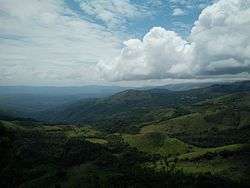 Western Ghats in Chikmagalur | |
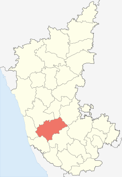 Location in Karnataka | |
| Coordinates: 13.32°N 75.77°E | |
| Country | |
| State | Karnataka |
| Taluk | Kadur, Chikmagalur, Tarikere, Mudigere, Sringeri, Koppa, Narasimharajapura, Kalasa |
| Government | |
| • Deputy Commissioner | Dr Bagadi Gautham |
| Area | |
| • Total | 7,201 km2 (2,780 sq mi) |
| Highest elevation | 1,925 m (6,316 ft) |
| Population (2011) | |
| • Total | 1,137,961 |
| • Density | 158.19/km2 (409.7/sq mi) |
| Languages | |
| • Official | Kannada |
| Time zone | UTC+5:30 (IST) |
| Vehicle registration |
|
| Website | chickmagalur |

Etymology
Chikmagalur district gets its name from its headquarters of Chikmagalur town. It is alternatively spelt as Chikkamagaluru or Chikmagalur. Chikmagalur literally means "The town of the younger daughter" in the Kannada language. The town is said to have been given as a dowry to the younger daughter of Rukmangada, the legendary chief of Sakkarepatna and hence the name.[2] As one can guess, there is indeed a town called Hiremagaluru which means "The town of the elder daughter" which is about 5 km from Chikmagalur town.
History
Chikmagalur is the region where the Hoysala rulers started and spent the early days of their dynasty. According to a legend, it was at Sosevur, now identified with Angadi in Mudigere Taluk that Sala, the founder of the Hoysala dynasty, killed the legendary tiger, immortalised in the Hoysala crest.[3][4] It is known that Veera Ballala II (1173 – 1220 CE), the great king of Hoysala empire, has built the Amriteshwara temple at Amrithapura in Tarikere Taluk.
Coffee was introduced into India through the Chikmagalur district when the first coffee crop was grown in the baba budan giri range during 1670 AD.[2] According to the article Origins of Coffee, the saint Baba Budan on his pilgrimage to Mecca travelled through the seaport of Mocha, Yemen where he discovered coffee. To introduce its taste to India, he wrapped seven coffee beans around his belly and got them out of Arabia. On his return home, he planted the beans in the hills of Chikmagalur.[1]
In recent history, Chikmagalur was the centre of global attention in the year 1978 when the former Indian Prime Minister, Indira Gandhi contested for elections here and got elected to Lok Sabha, the Indian Parliament.
Geography
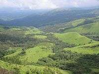
Chikmagalur, the headquarters of Chikmagalur district, is 251 kilometres (156 mi) from the state capital of Bangalore, and is surrounded by the Chandra Drona hills and dense forests. The district is between 12° 54´ 42´´ and 13° 53´ 53´´ North latitude and between 75° 04´ 46´´ and 76° 21´ 50´´ east longitude. Its greatest length from east to west is about 138.4 kilometers and from north to south 88.5 kilometers. The district receives normal average rainfall of 1925 mm. The highest point in the district is Mullayanagiri, 1,926 m above sea level which is also the highest point in the state of Karnataka. 30% of the district (2108.62 km²) is covered with forests.[5] The district borders Shimoga to the north, Davanagere to the north-east, Chitradurga and Tumkur districts to the east, Hassan to the south, Dakshina Kannada to the south-west and Udupi to the west. The rivers Bhadra, Tunga, Hemavathi, Netravati, and Vedavathi flow all year round. The district is rich in iron, magnetite and granite deposits. Black soil is found around Baba Budan Giri Hills whereas Red and Gravel soil are found in the southern parts of the district.

.jpg)

Demographics
According to the 2011 census, Chikmagalur district has a population of 1,137,961,[6] roughly equal to the nation of Cyprus[7] or the US state of Rhode Island.[8] This gives it a ranking of 408th in India (out of a total of 640).[6] The district has a population density of 158 inhabitants per square kilometre (410/sq mi) .[6] Its population growth rate over the decade 2001–2011 was −0.28%.[6] Chikmagalur has a sex ratio of 1005 females for every 1000 males,[6] and a literacy rate of 79.24%.[6]
81% of the population resides in rural area with the remaining 19% being the urban population. Among taluks, Sringeri taluk has the least population whereas Chikmagalur taluk has the highest population.
Kannada is the language spoken in this district.
| Historical population | ||
|---|---|---|
| Year | Pop. | ±% p.a. |
| 1901 | 359,270 | — |
| 1911 | 338,457 | −0.59% |
| 1921 | 333,538 | −0.15% |
| 1931 | 347,715 | +0.42% |
| 1941 | 358,290 | +0.30% |
| 1951 | 417,538 | +1.54% |
| 1961 | 597,305 | +3.65% |
| 1971 | 736,647 | +2.12% |
| 1981 | 911,769 | +2.16% |
| 1991 | 1,017,283 | +1.10% |
| 2001 | 1,140,905 | +1.15% |
| 2011 | 1,137,961 | −0.03% |
| source:[9] | ||
Administration
Chikmagalur district falls under the Mysore Division of Karnataka. It is divided into two Revenue Sub-divisions, Chikmagalur Sub-Division and Tarikere Sub-Division. Chikmagalur Sub-Division comprises the taluks of Chikmagalur, Koppa, Mudigere and Sringeri whereas the Tarikere Sub-Division comprises the taluks of Tarikere, Kadur, Ajjampura and Narasimharajapura. The Deputy Commissioner (also the District Magistrate) is the functional head of the district. Each Sub-Division has Assistant Commissioners and each Taluk has Tahsildars who work under the control and supervision of the Deputy Commissioner. The current administrative setup of the district can be viewed here .
Economy
Agriculture is the economical back bone of the Chikmagalur district with coffee cultivation forming the major part of it. Agricultural production in the district is spread over three seasons — namely Kharif, Rabi and Summer. Important crops grown are cereals, i.e. rice, ragi, jowar, maize and minor millets, pulses like red gram, horse gram, green gram, avrekai (Hyacinth Beans), black gram and Bengal gram. Oil seeds like groundnut, sesamum, sunflower, castor and commercial crops like sugarcane, cotton, and tobacco are also grown here.[10]
The Coffee Board located in Chikmagalur town is the government authority that oversees the production and marketing of coffee cultivated in the district. Coffee is cultivated in Chikmagalur district in an area of around 85,465 hectares with Arabica being the dominant variety grown in upper hills and Robusta being the major variety in the low level hills. There are around 15000 coffee growers in this district with 96% of them being small growers with holdings of less than or equal to 4 hectares. The average production is 55,000 MT: 35,000 MT of Arabica and 20,000 MT of Robusta. The average productivity per hectare is 810 kg for Arabica and 1110 kg of Robusta, which are higher than the national average.[11]
Industries
Chikmagalur district unfortunately has not made good progress in terms of Industrial Development. Inadequate infrastructure, poor roads, poor rail network and investors preferring non-industrial ventures over industrial ones are quoted as some of the reasons for the backwardness of Industrial Development in this district.[12][13]
There is only one Large Scale industry in this district, i.e. M/s Kudremukh Iron Ore Company Ltd. (KIOCL) in Kudremukh area of Mudigere Taluk. KIOCL was established in 1976 to develop the Kudremukh mine and to produce 7.5 million tonnes of concentrate per year. The facilities were commissioned in 1980 and the first shipment of concentrate was made in October 1981. A pelletisation plant with a capacity of 3 million tonnes per year was commissioned in 1987 for production of high quality blast furnace and direct reduction grade pellets for export.[14] KIOCL received a massive setback when its mining licence expired and operations were stopped by the Supreme Court with effect from 31 December 2005.[15] With many of the employees losing their jobs and the social backlash that may result thereof, efforts are being made to generate jobs for these workers in other areas.[16]
There is only one medium-scale industry, i.e. M/s Vignyan Industries Ltd. located in Tarikere town. A subsidiary of BEML, it produces steel castings.
There are two industrial estates in Chikmagalur district, one located near Chikmagalur town and the other near Birur in Kadur Taluk. The Chikmagalur Industrial Estate is spread over 13.20 acres (53,400 m2) of land where the one at Birur is spread over 11.1 acres (45,000 m2). Karnataka Industrial Area Development Board (KIADB) is also developing an Industrial Area of over 145 acres (0.59 km2) near Amble village of Chikmagalur taluk.[17]
Education
According to 2011 census, the percentage literacy rate of Chikmagalur district is 79.25% with 85.41% of males and 73.16% of females being literate. The literacy rate of Chikmagalur is higher than the average literacy rate of Karnataka state which is 75.36%. Sringeri Taluk has the highest literacy rate of 92.68% and Kadur Taluk with 74.33% being the least literate one.[18]
As of 2011, there are 13 degree colleges (with 4615 students) offering graduate education in Chikmagalur district[19] which are affiliated to Kuvempu University. Chikmagalur taluk has the maximum 4 graduate colleges (with 1648 students) whereas kadur has 2 and Koppa, Mudigere, Narasimharajapura and Sringeri taluks have only 1 graduate college each.
Primary and secondary education
As of 2001, there are 1620 primary schools (with 151923 students) and 235 secondary schools (high schools with 34607 students) in Chikmagalur district.[19] Chikmagalur taluk with 414 primary schools (42774 students) has the most primary schools with Sringeri Taluk having the fewest at 80 primary schools (5822 students). Kadur Taluk with 74 secondary schools (9990 students) has the most secondary schools with Sringeri Taluk having the fewest at 9 secondary schools (1492 students).
Higher secondary education
As of 2001, there are 46 colleges (with 4711 students) offering Higher Secondary (Pre-University) education in Chikmagalur district.[19] Kadur Taluk with 12 Higher-Secondary colleges (1324 students) has the most number of Higher-secondary colleges with Sringeri Taluk having the least number of 2 Higher-secondary colleges (160 students).
Pre-University College
- St. Mary's Pre-University College, K M Road, Chikkamagaluru-577101
- Sri Sai Angels Pre-University College, Sirgapura, Malalur Post, Chikkamagaluru-577133
- Elite Pre-University College, Opp.Zilla Panchayath, Jyothinagara, Chikkamagaluru-577102
- Town Mahila Samaja(TMS) Pre-University College, Opp. SBM, District Court Road, Chikkamagaluru-577101
- Government Junior College, Belur Road, Chikkamagaluru-577101
- St. Joseph's Pre-University College, K M Road, Chikkamagaluru-577102
- BGS Pre-University College, Housing Board, Chikkamagaluru-577102
- MES pre university college,NMC circle chikkamagalur-577101
Technical education
- Engineering: There is an Engineering College located in Chikmagalur town named Adichunchanagiri Institute of Technology. The courses offered here are Mechanical Engineering, Computer Science Engineering, Electronics and Communication Engineering, Electrical and Electronics Engineering, Information Science and technology, Industrial production Engineering, Environmental Engineering and Civil Engineering. This college is affiliated to Visweswariah Technological University located at Belgaum.
- Polytechnics: There are 3 polytechnics offering diploma courses to students in Chikmagalur district.[20] They are:o
- Adichunchanagiri Institute of Technology Polytechnic, Chikmagalur: Offering Diploma courses in Electronics and Communication and Computer Science
- DACG (GOVT) Polytechnic, Chikmagalur: Offering Diploma courses in Civil Engineering, Electrical Engineering, Mechanical Engineering, Automobile Engineering, Computer Science and Engineering, Electronics and Communication Engineering
- SJMM Vidyapeeta Polytechnic, Birur: Offering Diploma courses in Civil Engineering and Telecommunication Engineering.
- Industrial Training Institutes: There are 7 Industrial training institutes in Chikmagalur district.[20] They are:
- Government Industrial Training Institute, Chikmagalur
- Government Industrial Training Institute, Kadur
- SDM Industrial Training Institute, Samse, Mudigere Taluk
- SJR Industrial Training Institute, Balehonnur, Narasimharajapura Taluk
- SJM Industrial Training Institute, Birur, Kadur Taluk
- Karnataka Industrial Training Institute, Chikmagalur
- Lakshmisha Industrial Training Institute, Devanoor, Kadur Taluk.
- Maruthi Industrial Training Institute, Kadur
Medical education
A new medical college has been sanctioned to Chikmagalur city but the construction work has not yet been started. The only source of medical education in the Chikmagalur district is Arror Laxminarayan Rao Memorial Ayurvedic Medical college in Koppa. This college offers the Bachelor of Ayurvedic Medicine and Surgery (BAMS) degree.
Transport
Road
Chikmagalur district is known for not well maintained roads.[21][22] The poor state of the roads has hampered development of this district to some extent; more so because of the absence of even a good rail network in this district.[23] The total length of roads in this district is 7264 km.[5] There are only three National Highways that pass through this district. The National Highway NH-206 (Bangalore to Honnavar) passes through the towns of Kadur, Tarikere and NH-173 passes through Kadur - Chikkamagaluru - Mudigere connecting Mangaluru via charmadi ghat. There is a proposal to upgrade.[24]
Rail
Chikmagalur, Kadur and Tarikere taluks have railway lines passing through them. The total length of railway line passing through the district is 136 Kadur is the main big Junction of Chikmagalur District. A new railway line connecting Chikmagalur to the main Hubli–Bangalore trunk line was newly inaugurated and the commencment of the new line connecting Chikmagalur to the Bangalore–Mangalore trunk line has already been started.
Tourist spots
Hill stations
- Kemmangundi: 55 kilometres (34 mi) north from Chikmagalur town is Kemmangundi. Lingadahalli is the junction point to go for Kemmangundi, a scenic hill station on the Baba Budan Giri range of hills. Kemmangundi is also known as K.R. Hills after the Wodeyar King, Krishnaraja Wodeyar, who had made it his favourite summer camp. Kemmangundi, at a height of 1,434 meters, is surrounded by thick forests and a salubrious climate throughout the year. It is surrounded by the Baba Budan Giri range and blessed with silver cascades of mountain streams and lush vegetation. Its beautifully laid out ornamental gardens and enchanting mountain and valley views are a treat to the eye. Spectacular sunsets are a must see from various locations in the district, even from the Raj Bhavan. For the adventurous, Kemmangundi offers many peaks to scale and intricate jungle paths to explore. This place has a beautiful rose garden and other attractions. There is a place called Z-point at about 10 minutes walk from this main place which gives a nice aerial view of the Shola grass lands of the Western Ghats.
- Kudremukh and Kudremukh National Park: 95 km southwest of Chikmagalur town is Kudremukh range (in Kannada Kudure = horse and mukha = face), so named because of the unique shape of the Kudremukh peak. Overlooking the Arabian Sea, the broad hills are chained to one another with deep valley & steep precipices. Situated at 1,894.3 meters above sea level, Kudremukh is rich in iron ore deposits. The Kudremukh Iron Ore Company conducts mining operations, benefaction and transportation of the ore as slurry through pipelines to the port at Panambur near Mangalore.
- Mullayanagiri: Mullayanagiri is part of the Baba Budan Giri Hill Ranges here. It stands 1930 meters tall and is the tallest peak in Karnataka. Its height is famous mostly for watching sunsets from. It is 16 km from Chikmagalur town. Driving to Mullayanagiri is worth taking a risk. On the way is Sitalayanagiri where the water in the Shiva temple neither increases nor decreases. The road to Mullayanagiri is very narrow with a views from steep cliffs. Driving to the peak is not possible and includes a trek up the hill from the halfway point. There is a temple on top of the hill. From the topmost point of the hill the Arabian Sea is visible on clear days. The small hillock in the temple compound is the highest point in Karnataka. The narrow road to the temple makes two way traffic impossible. It is a great trekking spot in Karnataka.
- Baba Budan Giri also known as Datta Peeta: To the north of Chikmagalur town is the Baba Budan Giri Range or Chandra Drona Parvatha as it was known in the ancient times, which has one of the highest mountain peaks between the Himalayas and the Nilgiris. The peak takes its name from the Muslim saint Baba Budan and is known for its shrine to the Sufi saint Hazrat Dada Hayat Khalandar (Who planted Coffee Beans for the first time in this same range).
- Deviramma Betta and Temple - Deviramma is a popular deity in the region. Many Deiviramma temples are present in the region. The one present on the peak of Deviramma hill close to Baba Budan Giri is popular. Devirammana Betta is one of the three major hills in the range. The Hill is very steep and pointed. Temple is open only on the first day of Diwali festival time. Laks of people trek to this temple [Access point may vary!]. At Bindiga, a new temple of Deviramma is built, which is located at the foothill, 18 km north of Chikmagalur town, easily accessed by car. This temple is nice and location is serene with a background of three majestic peaks of western ghats, viz., Mullayanagiri, Baba Budan giri and Deviramma hills.
Waterfalls, dams and lakes
- Manikyadhara Falls is a waterfall near the famous pilgrim centre Baba Budan Giri Dattatreya Peetha where water spills down like small pearls giving the visitors a memorable shower bath.
- Kallathigiri Falls: Just 10 km from Kemmangundi is Kallahathigiri falls. Water cascades down from the top of the Chandra Drona hill from a height of 122 meters amidst fascinating scenery. There is an old Veerabhadra temple dedicated to Lord Shiva, constructed in a gap between rocks. This temple can be approached after crossing the waterfall.
- Hebbe Falls: This beautiful waterfall is over 10 km from the famous hill station, Kemmangundi. Here water streams down from a height of 168 meters in two stages to form Dodda Hebbe (Big Falls) and Chikka Hebbe (Small Falls).
- Shanti Falls: This is a beautiful waterfall on the way to Z-Point in Kemmangundi.
- Shankar Falls: This beautiful waterfall is 3km from Aldur(Shooting Spot).
- Hanumana Gundi Falls: Located 32 km (20 mi) from Kalasa and 79 km (49 mi) from Mangalore,[26] it has an elevation of 996 m (3,268 ft).[27] The waterfall has water falling onto Natural rock formations from a height of 72 ft (22 m).
- Kadambi Falls: This is a waterfall located in the Kudremukh National Park.
- Sirimane Falls: This is a waterfall located about 14 km from Sringeri town.
- Bhadra Dam: one of the oldest and scenic dam in Karnataka located in Lakkavalli near Tarikere.
- Hirekolale lake:Near Chikmagalur town.[28]
- Ayyenkere lake: Located 20 km from Chikmagalur.[29]
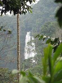
- Sagir Ahmed/Dabdabe Falls: This waterfall is located on the way to Bababudangiri.
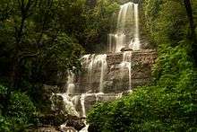 Sagir Ahmed or Dabdabe falls which is located in Chikmagalur district of Karnataka
Temple towns

- Sringeri: 90 km west of Chikmagalur town is Sringeri situated on the banks of Tunga, a Vedic Peetha established by Sri Adi Shankara, the exponent of the Advaita philosophy in the 9th century A.D. It is famous for Vidyashankara Temple originally constructed by the Hoysalas and later completed by the founders of the Vijayanagar Empire and Sharada temple, an early 20th. century addition. In the Vidya Shankara shrine, there are 12 zodiac pillars, which are so constructed that the rays of the sun fall on the pillar corresponding to the month.
- Horanadu: Horanadu is 100 km southwest of Chikmagalur and has an ancient Annapoorneshwari Temple, which has been renovated recently. With the installation of the new image of Adi Shakti, now the temple is called Adi-Shaktyatmaka Shri Annapoorneshwari. The place attracts lots of pilgrims who are provided free boarding and lodging by the temple.
- Kalasa: Kalasa is 92 km southwest of Chikmagalur and situated on the banks of the river Bhadra. It is surrounded by lofty hills of the Western Ghats and is looked upon as one of the pancha-kshetras on the banks of the Bhadra. Close by are the pancha theerthas, the five sacred ponds. On a small hillock here is the Kalaseshwara temple in dedicated to Ishwara, with a Kshetrapala shrine of soap stone in Hoysala style nearby. The Madhawacharya bande, a large boulder at one of the theerthas here, is supposed to have been placed by Shri Madhawacharya the founder of the Dvaita school of philosophy. A statue of this acharya is carved on the upper portion of the rock.
- Narasimharajapura: The Simhanagadde Jwalamalini Temple is located at the Simhanagadde town near Narasimharajapura in Chikmagalur district.[30] This is one of the important Jain temples in Karnataka state. The temple houses an attractive black colored idol of Goddess Jwalamalini as the main deity.[31] The history of this idol dates back to the period around 15th and 16th century. The temple has a very spacious hall and a sanctoum sanctorum. This temple attracts huge number of devotees in India as well as foreign countries. The temple was renovated in 1994. Shri Kshetra Simhanagadde is famous for the Atishaya (place of miracles) of Jwalamalini Devi – Yakshini (guardian spirit) of the 8th Tirthankara, Shri Bhagwan Chandraprabhu in Jainism.[32]
- Someshwara Temple, Sompur - 10 km east of Lakkavalli dam; 4 km north-west of Rangenahalli. 12th century temple, being renovated; one of the 5 major pilgrimage centres along Bhadra River
- Amritapura: 67 km north of Chikmagalur, Amrithapura is known for the Amriteshwara temple built in 1196 A.D by Amriteshwara Dandanayaka, a general of the Hoysala ruler Veera Ballala II. Delicacy of touch, originality of design and fine features have made this temple one of the notable structures of the Hoysala period.
- Guru Dattatreya Bababudanswamy Darga: Situated on the Baba Budan Giri is the Inam Dattatreya Peetha venerated by the Hindus and the Muslims alike. A laterite cave here is believed to have been sanctified by the residence of Dattatreya Swami as well as Hazrat Dada Hayat Mir Khalander. The worship here is conducted by a fakir and the annual jatra or urs is attended by both Hindus and Muslims with great fervors.
- Kodanda Ramaswamy Temple, Hiremagalur
- Belavadi: Located 29 km southeast of Chikmagalur town on the Chikmagalur–Javagal road and 10 km north west of Halebidu, Belavadi is famous for Ornate temple of Veeranarayana. Belavadi is also famous for the temple of 'Udbhava Ganapathi'.
- Sri Channakeshava & Sri Siddeshwara Temple, SH57, Marle – [12th century temple; located close to Belavadi road]
- Ukkadagathri Ajjayya Swami, Hampapura - 5 km north east of Chikmagalur town
- Ayyanakere - vast ancient lake surrounded by hills and few ancient temples in the vicinity
- Deviramma Temple, Bindiga - newly built temple; nice location; well maintained; serene
- Nirvanaswamy Temple, Mavinahalli
- Seethālayanagiri Temple, Bhadra Wildlife Sanctuary, Pandaravalli [en route to Mulayangiri]
- Sri Markandeshwara Temple, Khandya – 10 km north-east of Balehonnur
- Sri Durgaparameshwari Temple, Melpal 12 km from Balehonnur.
- vinayaka temple,Ropeline
- Sri Mahalakshmi temple Keresanthe. keresanthe kadur tq .58 km far from district headquarter, keresanthe Sri lakkamma temple .
Other points of interest
- Rathnagiri Bore, Chikmagalur [garden area in the northern suburban area]
- Coffee Museum - located in Dasarahalli, Chikmagalur,
Wildlife
- Bhadra Wildlife Sanctuary: Occupying 495 km². of Wildlife Sanctuary and Project Tiger Reserve, this region is an important watershed of the Tungabhadra river. The huge reservoir here is the main water supply to several districts in the rain shadow regions of south Karnataka. The forests here are rich in Bamboo and birds species unique to both the Malabar and Sahyadri ranges.
- Kudremukh National Park: The Kudremukh National Park (latitudinal range 13°01'00" to 13°29'17" N, longitudinal range 75°00'55' to 75°25'00" E) is the largest declared Wildlife Protected Area (600 km²) of a tropical wet evergreen type of forest in the Western Ghats. The Western Ghats is one of the twenty-five hot spots identified for bio-diversity conservation in the world. Kudremukh National Park comes under the Global Tiger Conservation Priority-I, under the format developed jointly by Wildlife Conservation Society (WCS) and World Wide Fund-USA.
Gallery
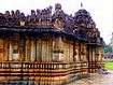 Profile, Amrutesvara temple (1196 C.E.) in Amruthapura, Chikmagalur district
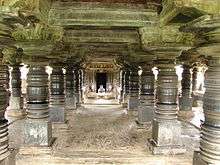 Navaranga, Amrutesvara temple in Amruthapura
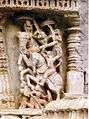 Wall carvings of the Amrutesvara temple in Amruthapura
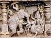 Wall carvings of the Amrutesvara temple in Amruthapura
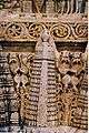 Wall carvings, Amrutesvara temple in Amruthapura
 Mountain stream near Sringeri
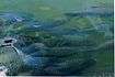 Fish in the Tunga river at Vidyashankara temple, Sringeri
- Adichunchanagiri Institute of Technology
- View of Mullayanagiri and Bababudangiri, Chikkamagaluru
Notes
- "About Chikkamagaluru". www.chickmagalur.nic.in. Archived from the original on 14 February 2016. Retrieved 19 July 2016.
- National Informatics Centre. "About Chikkamagaluru". The Official website of Chikkamagaluru. District Administration, Chikkamagaluru. Retrieved 16 March 2007.
- Angadi village in Chikmagalur district, where it is believed that king Sala, founder of Hoysala dynasty killed the tiger, will be made a major tourist destination, reports the Staff Correspondent in (19 October 2006). "Angadi to be made a major tourist destination". Online Edition of The Hindu ePaper — Issue Thursday, 19 October 2006. Chennai, India: 2006 The Hindu, From the publishers of the Hindu. Retrieved 16 March 2007.
- C. Hayavadhana Rao, J. D. M. Derrett, B. R Joshi call the Sala story a legend, Arthikaje, Mangalore. "History of Karnataka-Hoysalas and their contributions". 1998–2000 OurKarnataka.Com, Inc. Retrieved 16 March 2007.
- Geographical details of Chikmagalur district are discussed by National Informatics Centre. "Perspective Industrial Plan of Chickmagalur District". The Official website of Chikkamagaluru. District Administration, Chikkamagaluru. Retrieved 18 March 2007.
- "District Census 2011". Census2011.co.in. 2011. Retrieved 30 September 2011.
- US Directorate of Intelligence. "Country Comparison:Population". Retrieved 1 October 2011.
Cyprus 1,120,489 July 2011 est.
- "2010 Resident Population Data". U. S. Census Bureau. Archived from the original on 19 October 2013. Retrieved 30 September 2011.
Rhode Island 1,052,567
- Decadal Variation In Population Since 1901
- Agriculture forms the major part of Chikmagalur's economy; as discussed by National Informatics Centre. "Agriculture". The Official website of Chikkamagaluru. Dept. of Agriculture, District Administration, Chikkamagaluru. Retrieved 18 March 2007.
- Coffee cultivation in Chikmagalur is discussed by National Informatics Centre. "Coffe board". The Official website of Chikkamagaluru. Coffee Board, Chikkamagaluru. Retrieved 18 March 2007.
- Poor development of Industries in Chikmagalur district is discussed by National Informatics Centre. "Present Industrial Scenario of the district and SWOT analysis". The Official website of Chikkamagaluru. District Administration, Chikkamagaluru. Retrieved 18 March 2007.
- Glaring imbalances with respect to investments in the districts of Karnataka is discussed by Nagesh Prabhu. "Glaring regional imbalance in industrial investment". Online Edition of The Hindu ePaper — Issue Sunday, 30 April 2006. 2006 The Hindu, From the publishers of the Hindu. Retrieved 18 March 2007.
- The history of Kudremukh Iron Ore Company Ltd. is discussed in "KIOCL: Company Profile". The website of KIOCL. Kudremukh Iron Ore Company Ltd. Archived from the original on 11 August 2007. Retrieved 17 March 2007.
- The Supreme Court permitted KIOCL to mine iron ore in Kudremukh area only till 31 December 2005 reports Ministry of Steel. "Press Release". The website of Press Information Bureau, Govt. of India, 2 December 2002. 2002, Press Information Bureau, Govt. of India. Retrieved 18 March 2007.
- Faced with the threat of losing jobs due to impending closure of Kudremukh mines, the workers and management have appealed for allotting them an alternative mining site to eke out a living reports PTI. "Workers, Management of Kudremukh mines seek alternative mine". Mar 09, 2007 NewKerala.com. 2007, Press Trust of India. Retrieved 18 March 2007.
- Industrial Estates and Industrial Areas in Chikmagalur district are reported by National Informatics Centre. "Present Industrial Scenario of the district and SWOT analysis". The Official website of Chikkamagaluru. District Administration, Chikkamagaluru. Retrieved 18 March 2007.
- http://www.census2011.co.in/census/district/250-chikmagalur.html
- Statistics IX, The Official website of Chikkamagaluru
- Colleges offering Technical Education in Chikmagalur district are discussed in National Informatics Centre. "Socio-Economic Infrastructure". The Official website of Chikkamagaluru. District Administration, Chikkamagaluru. Retrieved 19 March 2007.
- The damage to roads in the district, including State highways and municipal roads is unprecedented reports the Correspondent in (25 September 2005). "BJP threatens stir over bad roads in Chikmagalur". Online Edition of The Hindu ePaper – Issue Thursday, 25 September 2005. Chennai, India: 2005 The Hindu, From the publishers of the Hindu. Retrieved 18 March 2007.
- Deplorable condition of Chickmagalur roads and money being released to address the issue is reported by Correspondent in (5 January 2007). "Chikmagalur district gets Rs. 27 crore for road repairs". Online Edition of The Hindu ePaper – Issue Thursday, Jan 5, 2007. Chennai, India: 2007 The Hindu, From the publishers of the Hindu. Retrieved 18 March 2007.
- In absence of good rail network, the roads play an important part for the industrial development. However, most of the roads in Chikmagalur district needs proper maintenance. Report by National Informatics Centre. "Present Industrial Scenario of the district and SWOT analysis". The Official website of Chikkamagaluru. District Administration, Chikkamagaluru. Retrieved 17 March 2007.
- Plans to upgrade some roads in Chikmagalur district is presented by National Informatics Centre. "Socio-Economic Infrastructure". The Official website of Chikkamagaluru. District Administration, Chikkamagaluru. Retrieved 18 March 2007.
- Proposal to construct an airport in Chikmagalur district is discussed by National Informatics Centre. "Socio-Economic Infrastructure". The Official website of Chikkamagaluru. District Administration, Chikkamagaluru. Retrieved 18 March 2007.
- "Distance between Mangalore - Hanuman Gundi Falls". Retrieved 19 November 2017.
- "Elevation maps with Altitude - Hanuman Gundi".
- Travel and Tourism Guide in India, Book Hotels for Tours and Travels – Native Planet. Gallery.holidaymakers.in (13 November 2015). Retrieved on 2015-11-19.
- Top Chikmagalur, India Things to Do on VirtualTourist. Virtualtourist.com. Retrieved on 19 November 2015.
- Narasimharajapura. Karnatakaholidays.com. Retrieved on 19 November 2015.
- Simhanagadde. Karnatakaholidays.com. Retrieved on 19 November 2015.
- Simhanagadde. Jain.org. Retrieved on 19 November 2015.
External links
| Wikimedia Commons has media related to Chikkamagaluru district. |
| Wikivoyage has a travel guide for Chikmagalur. |
District HQ: Chikkamagaluru | |
| Villages and Towns |
|
| Bangalore division | |
|---|---|
| Belgaum division | |
| Gulbarga division | |
| Mysore division |
|