Chitradurga
Chitradurga (also known locally as Durga) is a city and the headquarters of Chitradurga district which is located on the valley of the Vedavati river in the central part of the Indian state of Karnataka.[2] Chitradurga is a place with historical significance which is located to the North West about 200 km from the state capital Bengaluru. Chitradurga is a Major tourist hub in Karnataka. The City is famous for its Fort It is also locally known as "Kallina Kote" or Stone Fortress, which is also formed of two Kannada words ‘Kallina’: "Stone" and Kote: "Fort". Other names used in Kannada are ‘Ukkina Kote": "Steel Fort" (metaphorically used to mean an Impregnable fort) and ‘Yelusuttina Kote’: "Seven Circles Fort". Chitradurga is very distinctive with its curious myths, human dwellings dating back to Stone age, enriched with the sites of ancient, historical, cultural and religious significance has been a place with a civilization of thousands of years and an amalgamation of antiquity and modernisation.
Chitradurga Durga | |
|---|---|
City Municipal Council | |
| Nickname(s): Fort City (Kote Nadu) | |
 Chitradurga | |
| Coordinates: 14.23°N 76.4°E | |
| Country | |
| State | Karnataka |
| Region | Bayaluseeme |
| District | Chitradurga |
| Established | 1565 |
| Founded by | Thimmanna Nayaka |
| Government | |
| • Type | City Municipal Council |
| • Member of Parliament | A Narayanaswamy[1] |
| Area | |
| • Total | 43.11 km2 (16.64 sq mi) |
| Elevation | 732 m (2,402 ft) |
| Population (2018) | |
| • Total | 1,75,170 |
| Demonym(s) | Durgan, Durgans, Durgadavaru |
| Languages | |
| • Official | Kannada |
| Time zone | UTC+5:30 (IST) |
| PIN | 577501, 577502 |
| Telephone code | 08194 |
| Vehicle registration | KA-16 |
| Website | https://chitradurga.nic.in |
Etymology
Chitradurga gets its name from Chitrakaldurga (or Picturesque castle), an umbrella-shaped lofty hill found here. Chitradurga was also known by the names Chitradurg, Chitrakaladurga, Chittaldurg. Chittaldrug (or Chitaldrug[2]) was the official name used during the British rule. Also known as Farkhabad during Tippu sultan rule.[3]
History
Chitradurga features bold rock hills and picturesque valleys, huge towering boulders in numerous shapes. It is known as the "stone fortress" (Kallina Kote). According to the epic Mahabharatha, it is confirmed about this story that a man-eating Rakshasa named Hidimba and his sister Hidimbi lived on the hill. Hidimba was a source of terror to everyone around while Hidimbi was a peace-loving rakshasa. When the Pandavas came with their mother Kunti in the course of their exile, Bhima had a duel with Hidimba in which Hidimba was killed. Thereafter Bhima married Hidimbi and they had a son named Ghatotkacha who had magical powers. Legend has it the boulders were part of the arsenal used during that duel. In fact, the boulders on which major part of the city rests belong to the oldest rock formation in the country.
Timmana Nayaka, a chieftain under the Vijayanagar Empire, rose to the rank of governor of Chitradurga as a reward from the Vijayanagara ruler, for his excellence in military services,. This was the beginning of the rule of the Nayakas of Chitradurga. His son Obana Nayaka is known by the name Madakari Nayaka (1588 CE). Madakari Nayaka's son Kasturi Rangappa (1602) succeeded him and consolidated the kingdom to rule peacefully. As he had no heirs to succeed him, his adopted son, the apparent heir was enthroned but was killed in few months by the Dalavayis.
Chikkanna Nayaka (1676), the brother of Madakari Nayaka II sat on the throne, and his brother succeeded him with the title Madakari Nayaka III in 1686. The unwillingness of Dalawayis to accept Madakari Nayaka III's rule gave an opportunity to one of their distant relatives, Bharamappa Nayaka to ascend the throne in 1689. He is known as the greatest of the Nayaka rulers. The subjects of Chitradurga did not experience a good reign of the successive rulers as they ruled on the throne for very brief periods. The Hiri Madakari Nayaka IV (1721), Kasturi Rangappa Nayaka II (1748), Madakari Nayaka V (1758) ruled this area but there is not much to mention of their rule.[4]
Legend of Onake Obavva
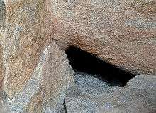
During the reign of Madakari Nayaka, (He was the last ruler of Chitradurga. His name comes from his ability to have subsided the arrogance- "Mada" of a particular troublesome elephant- "Kari") the town of Chitradurga was besieged by the troops of Hyder Ali. A chance sighting of a woman entering the Chitradurga fort through an opening in the rocks led to a clever plan by Hyder Ali to send his soldiers through the hole. The guard on duty near that hole had gone home for lunch. The wife of that guard, Obavva was passing by the hole to collect water, when she noticed soldiers emerging out of this opening. Obavva was not perturbed. She was carrying with her an Onake (a long wooden club meant for pounding paddy grains). She killed Hyder Ali's soldiers one by one as they attempted to enter the fort through the opening and quietly moved the dead. Over a short period of time hundreds of soldiers entered and fell, without raising any suspicion. Obavva's husband, upon his return from his lunch was shocked to see Obavva standing with a blood stained Onake and hundreds of dead bodies of the enemy around her. Together both wife and husband beat up most of the soldiers. But as both of them were about to finish off all the soldiers of Hyder Ali, Obavva dies. The opening in the rocks still remains as a historical witness for the story, beside The Tanniru doni the well which Obavva was making her way to, when she found the soldieres of Hyder Ali. Though her brave attempt saved the fort on that occasion, Madakari Nayaka could not repel Hyder Ali's attack in 1779. In the ensuing battle, the fort of Chitradurga was lost to Hyder Ali. Obavva, like Kittur Rani Chennamma remains a legend, especially to the women of Karnataka.[5][6][7][8]
Geography
Chitradurga is located at 14.23°N 76.4°E.[9] It has an average elevation of 732 metres (2401 ft).
Chitradurga city is well connected to Bengaluru, Mysuru, Mangaluru, Davanagere, Hubballi, Hospet, Bellary, Shivamogga, Tumakuru, Vijayapura, Belagavi, ... ,etc. by Bus through KSRTC.
Both NH-4 & NH-13 meets at Chitradurga City.
Chitradurga city is well connected to Bengaluru, Mysuru, Delhi, Varanasi, Hospet, Bellary, Tumakuru, ... ,etc through Railways.
Geology: national geological monument
Mardihalli Pillow lavas national geo-monument at Mardihalli village near Hiriyur has been declared the National Geological Monuments of India by the Geological Survey of India (GSI), for their protection, maintenance, promotion and enhancement of geotourism.[10][11][12]
Climate
The climate here is considered to be a local steppe climate. During the year, there is little rainfall in Chitradurga. The Köppen-Geiger climate classification is BSh. The temperature here averages 25.3 °C. The rainfall here averages 576 mm.
| Climate data for Chitradurga (1981–2010, extremes 1901–2012) | |||||||||||||
|---|---|---|---|---|---|---|---|---|---|---|---|---|---|
| Month | Jan | Feb | Mar | Apr | May | Jun | Jul | Aug | Sep | Oct | Nov | Dec | Year |
| Record high °C (°F) | 33.9 (93.0) |
37.1 (98.8) |
38.9 (102.0) |
39.8 (103.6) |
41.7 (107.1) |
39.2 (102.6) |
34.4 (93.9) |
32.8 (91.0) |
35.0 (95.0) |
35.0 (95.0) |
33.0 (91.4) |
33.5 (92.3) |
41.7 (107.1) |
| Average high °C (°F) | 29.4 (84.9) |
32.3 (90.1) |
35.0 (95.0) |
36.1 (97.0) |
34.9 (94.8) |
30.6 (87.1) |
28.5 (83.3) |
27.9 (82.2) |
29.3 (84.7) |
29.4 (84.9) |
28.5 (83.3) |
28.0 (82.4) |
30.8 (87.4) |
| Average low °C (°F) | 16.9 (62.4) |
19.1 (66.4) |
21.7 (71.1) |
22.9 (73.2) |
22.6 (72.7) |
21.7 (71.1) |
21.1 (70.0) |
20.7 (69.3) |
20.6 (69.1) |
20.3 (68.5) |
18.3 (64.9) |
16.7 (62.1) |
20.2 (68.4) |
| Record low °C (°F) | 9.4 (48.9) |
12.2 (54.0) |
14.6 (58.3) |
16.4 (61.5) |
12.6 (54.7) |
17.2 (63.0) |
17.8 (64.0) |
17.8 (64.0) |
15.0 (59.0) |
13.9 (57.0) |
8.3 (46.9) |
8.3 (46.9) |
8.3 (46.9) |
| Average rainfall mm (inches) | 2.2 (0.09) |
3.6 (0.14) |
6.1 (0.24) |
38.1 (1.50) |
65.3 (2.57) |
67.8 (2.67) |
69.4 (2.73) |
99.5 (3.92) |
113.9 (4.48) |
128.2 (5.05) |
54.3 (2.14) |
12.5 (0.49) |
660.9 (26.02) |
| Average rainy days | 0.3 | 0.4 | 0.7 | 2.5 | 4.1 | 5.5 | 7.8 | 8.5 | 6.7 | 6.8 | 2.8 | 0.9 | 47.1 |
| Average relative humidity (%) (at 17:30 IST) | 34 | 26 | 25 | 30 | 41 | 64 | 71 | 74 | 64 | 59 | 53 | 74 | 49 |
| Source: India Meteorological Department[13][14] | |||||||||||||
Demographics
As of 2011 India census,[15] Chitradurga had a population of 1,25,170. Males constitute 51% of the population and females 49%. Chitradurga has an average literacy rate of 76%, higher than the national average of 59.5%; with male literacy of 80% and female literacy of 72%. 11% of the population is under 6 years of age.
Administration
Chitradurga city is administered by the Chitradurga city municipal council.[16]
Renewable Energy
Chitradurga situated in a hilly region is also known to experience wind currents throughout the year making it a suitable place to set up wind mills and wind farms. There are several Wind-Power based power plants located around Chitradurga and most of the hills are embellished with wind mills which can be seen while entering the city. These wind farms have a total installed capacity of 49.7 MW.
Historical Places
Chitradurga Fort
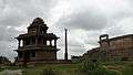
Chitradurga Fort was built between the 10th and 18th centuries by the kings various dynasties during that period which are Rashtrakutas, Kalyana Chalukyas, Hoysalas, Vijayanagar and Nayakas of Chitradurga. After Nayakas lost it to Hyder Ali in the year 1779, the fort was given its finishing touches by Hyder Ali along with his son Tipu Sultan. It comprises a series of seven enclosure walls in Kannada. On the upper part of the fort Eighteen ancient temples can be found and in the lower part of the fort there is one huge temple. Among these temples the oldest and most interesting is the Hidimbeshwara temple. The masjid was an addition during Hyder Ali's rule. The fort's many interconnecting tanks were used to harvest rainwater, and the fort was said to never suffer from a water shortage. This seemingly impregnable fort has 19 gateways, 38 posterior entrances, a palace, a mosque, granaries, oil pits, four secret entrances and water tanks.[17]
Chandravalli
Chandravalli caves is located amidst three hills namely Chitradurga, Cholagudda and Kirubanakallu. These caves are a never-ending maze of steep steps that lead into passageways, rooms and ante-rooms where kings from the Kadamba, Satavahana and Hoysala dynasties resided. And saints of the Ankali Math of Belgaum meditated in the temples. These caves are well ventilated but there is no light as its pitch dark inside the secret rooms that's why the kings used these rooms in case there was a threat of an intrusion.[17]
Gallery
| Wikimedia Commons has media related to Chitradurga. |
 Gaali mantapa
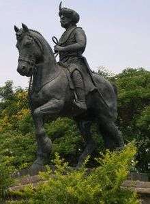 Madakari Nayaka statue
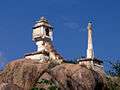 Nandi
Nandi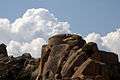 Fort
Fort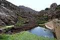 Pond View
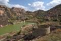 Inside View of Fort
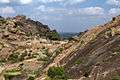 Another view of Fort
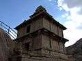 Gopura
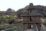 Temples inside the fort
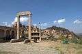 Stone Pillars
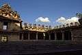 Sampige Siddalingeshwara Temple
See also
References
- "Chitradurga MP". NIC. Archived from the original on 26 October 2014. Retrieved 13 October 2014.
- Chisholm, Hugh, ed. (1911). . Encyclopædia Britannica. 6 (11th ed.). Cambridge University Press. p. 247.
- "About Chitradurga". Chitradurga City Municipal Council. Archived from the original on 18 February 2006. Retrieved 19 February 2014.
- Suryanath U. Kamath, A Concise History of Karnataka, Bangalore, 2001
- "Tourism in Chitradurga". Chitradurga city municipal council. Archived from the original on 25 February 2014. Retrieved 19 February 2014.
- "Bharat: An Untold Story - Chitradurga". Tumbler.com. Retrieved 19 February 2014.
- "Chitradurga Fort". Chitradurga District. Retrieved 19 February 2014.
- "Synthetic track at Obavva stadium ready". Times of India.
- Falling Rain Genomics, Inc - Chitradurga
- "National Geological Monument, from Geological Survey of India website". Archived from the original on 12 July 2017. Retrieved 21 January 2019.
- "Geo-Heritage Sites". pib.nic.in. Press Information Bureau. 9 March 2016. Retrieved 15 September 2018.
- national geo-heritage of India, INTACH
- "Station: Chitradurga Climatological Table 1981–2010" (PDF). Climatological Normals 1981–2010. India Meteorological Department. January 2015. pp. 193–194. Archived from the original (PDF) on 5 February 2020. Retrieved 18 April 2020.
- "Extremes of Temperature & Rainfall for Indian Stations (Up to 2012)" (PDF). India Meteorological Department. December 2016. p. M94. Archived from the original (PDF) on 5 February 2020. Retrieved 18 April 2020.
- "Census of India 2011: Population details". Census Commission of India. Archived from the original on 16 June 2004. Retrieved 12 August 2015.
- "Home of Chitradurga City Municipal Council". Chitradurga City Municipal Council. Archived from the original on 18 February 2006. Retrieved 19 February 2014.
- "Bastion on the hill - Chitradurga Fort". The Hindu. 7 March 2013.