Balehonnur
Balehonnur is a city in Narasimharajapura taluk of Chikkamagaluru district of the Indian state of Karnataka.It is famous for the oldest dharma peetha amongst the five panchapeethas - Rambhapuri peetha of Veerashaiva sect of the Hindu religion.The Baba Bandesha Dargha The Sacred Place Of Muslim Community Is also Located Here.
Balehonnur | |
|---|---|
town | |
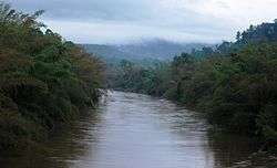 Bhadra River | |
 Balehonnur Location in Karnataka, India | |
| Coordinates: 13.35°N 75.46°E | |
| Country | |
| State | |
| District | Chikkamagaluru district |
| Region | Malenadu |
| Elevation | 714 m (2,343 ft) |
| Population (2011) | |
| • Total | 11,137 |
| Languages | |
| • Official | Kannada |
| Time zone | UTC+5:30 (IST) |
| PIN | 577 112 |
| Telephone code | 08266 |
| Vehicle registration | KA 18 |
Balehonnur is located 45 km to the north-west of the Chikmagalur town.
History
It is said that Shiva himself came out of the linga in human form as Paramacharya Renukacharya.[1] An ancient Islamic Saint called Baba Bandesha lived here, People still remembers him and Uroos takes place every year in the remembrance of him.
About
It is located on the bank of the Bhadra River and has an average rainfall of 80 inches (200 cm) a year. It is dominated by coffee estates, arecanut, paddy fields, pepper, vanilla and other spices. Even though Balehonnur is officially not a Taluk, it has various educational institutions, hospitals and a flourishing commercial centre.
Balehonnur Bridge
Balehonnur Bridge, constructed across the river Bhadra, was the first project undertaken by MCC in 1946. This masonry bridge was constructed across the river Bhadra by Madras Govt.
Religious places
- Rambhapuri peetha[2]
- Bandesha baba dargah
Road
Balehonnur is well connected by road. There are frequent buses to Shivamogga, Chickmagaluru, Sringeri, Koppa, Mangalore, Udupi, and Karkala. The state highway SH-27 cuts across Balehonnur which connects to the National Highway NH-13 at Sringeri. There are buses to Bangalore on a daily basis.[2]
Rail
The closest railway station is Chikmagalu - 50 km, Shivamogga - 87 km, Bhadravati - 83 km and Kadur - 90 km.[2]
Climate
| Climate data for Balehonnur (1981–2010, extremes 1933–2012) | |||||||||||||
|---|---|---|---|---|---|---|---|---|---|---|---|---|---|
| Month | Jan | Feb | Mar | Apr | May | Jun | Jul | Aug | Sep | Oct | Nov | Dec | Year |
| Record high °C (°F) | 36.0 (96.8) |
35.6 (96.1) |
38.0 (100.4) |
39.2 (102.6) |
38.6 (101.5) |
37.0 (98.6) |
31.4 (88.5) |
30.0 (86.0) |
31.4 (88.5) |
34.0 (93.2) |
32.6 (90.7) |
35.8 (96.4) |
39.2 (102.6) |
| Average high °C (°F) | 28.7 (83.7) |
31.0 (87.8) |
33.0 (91.4) |
32.8 (91.0) |
31.1 (88.0) |
26.6 (79.9) |
24.5 (76.1) |
24.2 (75.6) |
26.2 (79.2) |
27.1 (80.8) |
27.1 (80.8) |
27.4 (81.3) |
28.3 (82.9) |
| Average low °C (°F) | 13.5 (56.3) |
14.6 (58.3) |
16.8 (62.2) |
18.4 (65.1) |
19.0 (66.2) |
18.7 (65.7) |
18.4 (65.1) |
18.3 (64.9) |
17.9 (64.2) |
17.6 (63.7) |
16.0 (60.8) |
14.2 (57.6) |
16.9 (62.4) |
| Record low °C (°F) | 6.7 (44.1) |
8.0 (46.4) |
10.5 (50.9) |
11.1 (52.0) |
12.0 (53.6) |
9.6 (49.3) |
11.1 (52.0) |
11.2 (52.2) |
10.6 (51.1) |
9.1 (48.4) |
8.9 (48.0) |
7.3 (45.1) |
6.7 (44.1) |
| Average rainfall mm (inches) | 2.7 (0.11) |
2.8 (0.11) |
22.4 (0.88) |
94.6 (3.72) |
103.0 (4.06) |
410.6 (16.17) |
735.8 (28.97) |
626.2 (24.65) |
204.5 (8.05) |
173.6 (6.83) |
64.0 (2.52) |
11.8 (0.46) |
2,451.9 (96.53) |
| Average rainy days | 0.3 | 0.3 | 2.0 | 5.7 | 6.8 | 18.4 | 24.9 | 24.6 | 13.2 | 9.9 | 3.9 | 1.0 | 111.1 |
| Average relative humidity (%) | 79 | 78 | 77 | 81 | 84 | 90 | 92 | 93 | 90 | 88 | 82 | 79 | 85 |
| Source: India Meteorological Department[3][4] | |||||||||||||
References
- http://www.karnatakaholidays.com/rambhapuri-peeta-mutt.php
- "Station: Balehonnur Climatological Table 1981–2010" (PDF). Climatological Normals 1981–2010. India Meteorological Department. January 2015. pp. 71–72. Archived from the original (PDF) on 5 February 2020. Retrieved 18 April 2020.
- "Extremes of Temperature & Rainfall for Indian Stations (Up to 2012)" (PDF). India Meteorological Department. December 2016. p. M88. Archived from the original (PDF) on 5 February 2020. Retrieved 18 April 2020.