Bazoft District
Bazoft District (Persian: بخش بازفت) is a district (bakhsh) in Kuhrang County, Chaharmahal and Bakhtiari Province, Iran. At the 2006 census, its population was 14,270, in 2,459 families.[2] The district has one city: Bazoft, and two rural districts (dehestan): Bazoft Bālā and Bazoft Pāein.
Bazoft District (in Persian) بخش بازفت | |
|---|---|
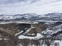 View of the Bazoft river with the Zardkuh mountain range in background | |
| Coordinates: 32°12′N 50°03′E | |
| Country | |
| Province | Chaharmahal and Bakhtiari Province |
| County | Kuhrang County |
| Elevation | 1,520 m (4,990 ft) |
| Population (2006 Census) | |
| • Total | 14,270[1] |
| Area code(s) | +(98) 383 |
Geography
In the heart of the Zagros mountains, in the foothills of the Zardkuh mountain range, the Bazoft district is located about 180km west of Shahrekord and 200km east of Masjed Soleyman on the Shahrekord-Masjed Soleyman road. The Bazoft river, located near the Zardkuh mountains, is one of the main affluents of the Karun river.
Population
At the 2006 census, its population was 14,270, in 2,459 families.[3] The population is mainly composed of Bakhtiari Lors from the Haft Lang tribes.
Gallery
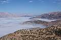 Bazoft valley under a heavy fog
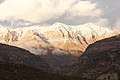 Zard Kuh mountains from the city of Bazoft
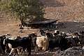 Bakhtiari nomads settlement
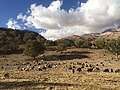 Goats and sheep in the foothill of Zardkuh
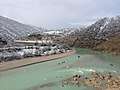 Bazoft river in winter
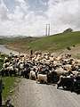 Nomadic transhumance in the village of Hossein Abad
References
- "Census of the Islamic Republic of Iran, 1390 (2011)". Islamic Republic of Iran. Archived from the original (Excel) on 2016-10-06.
- "Census of the Islamic Republic of Iran, 1385 (2006)". Islamic Republic of Iran. Archived from the original (Excel) on 2011-11-11.
- "Census of the Islamic Republic of Iran, 1385 (2006)". Islamic Republic of Iran. Archived from the original (Excel) on 2011-11-11.
- Bazoft District can be found at GEOnet Names Server, at this link, by opening the Advanced Search box, entering "10908563" in the "Unique Feature Id" form, and clicking on "Search Database".