Cape Northumberland (South Australia)
Cape Northumberland is a headland in the southeast of the Australian state of South Australia. It is the southernmost point of South Australia. It is located about 3 kilometres (1.9 mi) from the town of Port MacDonnell, 28 kilometres south southwest from the municipal seat of Mount Gambier and about 393 kilometres (244 mi) southeast of the state's capital Adelaide.[1][3][4]
| Cape Northumberland Port MacDonnell, South Australia | |
|---|---|
 Cape Northumberland, from the west | |
 Cape Northumberland | |
| Coordinates | 38°03′46″S 140°39′41″E[1] |
| Elevation | 30 m (98 ft)[2] |
| Location |
|
| Footnotes | Locations[1] |
History
Cape Northumberland was named by the Royal Navy officer, James Grant, on 3 December 1800, when he was mapping the southern coast of Australia in his early 1800s expedition. The headland was named after Hugh Percy, Duke of Northumberland. The cape is near the site of the historic Cape Northumberland Lighthouse, which was originally built in 1887. A new lighthouse has been built about 700 metres (2,300 ft) north of Cape Northumberland.[1][3]
Geography
The cape is located on the southeast coast of South Australia. It is the western end of Discovery Bay and its subsidiary, MacDonnell Bay.[1][2]:4 The cape was described in 2017 in an American source as being "about 30 metres (98 ft) high, is rugged and cliffy, with a hill rising to an elevation of 41 metres (135 ft) behind it.[2]:3 It is the southernmost point on the South Australian coastline.[1][5]
Gallery
 The first Cape Northumberland Lighthouse
 The sign at Cape Northumberland, marking South Australia's southernmost point
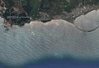 A satellite image of Cape Northumberland (left) showing its relationship to the coastline to its immediate east including the James Corcoran Breakwater[5]
References
- "Search results for 'Cape Northumberland, CAPE' with the following datasets selected - 'Suburbs and Localities, 'Government Towns' and 'Gazetter'". Location SA Map Viewer. South Australian Government. Retrieved 25 June 2018.
- Sailing Directions (Enroute), Pub. 127: East Coast of Australia and New Zealand (PDF). Sailing Directions. United States National Geospatial-Intelligence Agency. 2017. p. 3-4.
- "Northumberland, Cape". State Library of South Australia. Archived from the original on 3 April 2015. Retrieved 25 November 2014.
- South Australia. Department of Marine and Harbors (1985), The Waters of South Australia a series of charts, sailing notes and coastal photographs, Dept. of Marine and Harbors, South Australia, pp. Chart 2, ISBN 978-0-7243-7603-2
- Boating Industry Association of South Australia (BIA); South Australia. Department for Environment and Heritage (2005), South Australia's waters an atlas & guide, Boating Industry Association of South Australia, p. 179, ISBN 978-1-86254-680-6