Penola, South Australia
Penola is a town in the Australian state of South Australia located about 388 kilometres (241 mi) southeast of the state capital of Adelaide in the wine growing area known as the Coonawarra. At the 2006 census, Penola had a population of 1,317.[10]
| Penola South Australia | |||||||||||||||
|---|---|---|---|---|---|---|---|---|---|---|---|---|---|---|---|
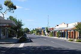 Penola town centre | |||||||||||||||
 Penola | |||||||||||||||
| Coordinates | 37°22′43″S 140°50′10″E[1] | ||||||||||||||
| Population |
| ||||||||||||||
| Established | 1867 (town) 13 December 2001 (locality)[1][4] | ||||||||||||||
| Postcode(s) | 5277 | ||||||||||||||
| Elevation | 65 m (213 ft) | ||||||||||||||
| Time zone | ACST (UTC+9:30) | ||||||||||||||
| • Summer (DST) | ACST (UTC+10:30) | ||||||||||||||
| Location | 388 km (241 mi) SE of Adelaide | ||||||||||||||
| LGA(s) | Wattle Range Council | ||||||||||||||
| Region | Limestone Coast[5] | ||||||||||||||
| County | Grey[1] | ||||||||||||||
| State electorate(s) | Mackillop[6] | ||||||||||||||
| Federal Division(s) | Barker[7] | ||||||||||||||
| |||||||||||||||
| |||||||||||||||
| Footnotes | Adjoining localities[1][8][9] | ||||||||||||||
It is known as the central location in the life of Mary MacKillop (St. Mary of the Cross), the first Australian to gain Roman Catholic sainthood,[11] who alongside Julian Tenison Woods in 1866 established the first free Catholic school[12] using the Woods/MacKillop Catholic education system in Australia,[13] St. Joseph's School.[14] Woods and MacKillop also established in Penola a congregation of religious sisters, the Sisters of St Joseph of the Sacred Heart. Otherwise known as the 'Josephites' or 'Brown Joeys', they continue to work with the poor and needy communities throughout the world today.[15]
Penola was on the Mount Gambier to Wolseley railway line which opened in 1887 until its closure to freight on 12 April 1995 and then to Limestone Coast Railway tourist passengers on 1 July 2006.[16]
History
The first Europeans to the area were the Austin brothers who arrived in 1840 and established a run of 109 square miles (282 km²). The first settlers were Scottish-born Alexander Cameron and his wife Margaret in January 1844 after obtaining an occupation licence. In April 1850, Cameron obtained 80 acres (0.3 km²) of freehold land (his station was on a pastoral lease) and established the private town of Panoola, later known as Penola.
By 1850, he had built the Royal Oak Hotel and was doing much business supplying liquor to the many travelers passing through to the Victoria goldfields. Penola Post Office opened around 1852.[17]
John Riddoch purchased Yallum in 1861. Riddoch grew up in poverty in the highlands of Scotland and in 1851 emigrated to try his luck on the Victoria goldfields. Within a few years he was a successful shopkeeper and wine merchant on the Geelong goldfields. He acquired 35,000 acres (142 km²) on which he ran 50,000 head of sheep.
It was Riddoch who planted the first grape vines and helped to diversify the pastoral economy of the area with an agricultural industry. In 1890, he established the Penola Fruit Growing Colony which was renamed Coonawarra in 1897.
In 2010, a strong tornado ripped through the township destroying at least four buildings and damaging many more.[18]
Heritage listings
Penola has a number of heritage-listed sites, including:
- 31 Arthur Street: St Andrew's Presbyterian Church [19]
- 23 Arthur Street: Penola Public Library and Mechanics Institute [20]
- Bowden Street: Ulva Cottage [21]
- Church Street: National Bank Building [22]
- 28 Church Street: Bank of South Australia Building [23]
- 31 Church Street: Heyward's Royal Oak Hotel [24]
- 31 Church Street: Penola Post Office and Dwelling [25]
- 118 Church Street: Bushman's Inn [26]
- Clarke Street: Penola railway station [27]
- off Penola Road: John Shaw Neilson's Cottage [28]
- Portland Street: Woods MacKillop Schoolhouse [29]
- 58 Riddoch Street: Penola Butter and Cheese Factory [30]
- 136 Wilson Street (Petticoat Lane): Sharam's First Cottage [31]
- 136 Wilson Street (Petticoat Lane): Sharam's Second Cottage [32]
Climate
| Climate data for Penola State Forest Reserve, Nangwarry, South Australia | |||||||||||||
|---|---|---|---|---|---|---|---|---|---|---|---|---|---|
| Month | Jan | Feb | Mar | Apr | May | Jun | Jul | Aug | Sep | Oct | Nov | Dec | Year |
| Record high °C (°F) | 44.0 (111.2) |
44.1 (111.4) |
41.3 (106.3) |
34.6 (94.3) |
28.5 (83.3) |
20.4 (68.7) |
22.0 (71.6) |
24.5 (76.1) |
31.2 (88.2) |
33.6 (92.5) |
39.5 (103.1) |
42.9 (109.2) |
44.1 (111.4) |
| Average high °C (°F) | 26.3 (79.3) |
27.3 (81.1) |
24.5 (76.1) |
21.0 (69.8) |
17.0 (62.6) |
14.0 (57.2) |
13.6 (56.5) |
14.7 (58.5) |
16.6 (61.9) |
19.2 (66.6) |
21.8 (71.2) |
24.5 (76.1) |
20.0 (68.0) |
| Average low °C (°F) | 11.8 (53.2) |
12.0 (53.6) |
11.2 (52.2) |
9.0 (48.2) |
7.2 (45.0) |
5.2 (41.4) |
4.5 (40.1) |
5.2 (41.4) |
6.5 (43.7) |
7.4 (45.3) |
9.0 (48.2) |
10.7 (51.3) |
8.3 (46.9) |
| Record low °C (°F) | 3.0 (37.4) |
2.3 (36.1) |
2.8 (37.0) |
0.0 (32.0) |
−0.5 (31.1) |
−2.2 (28.0) |
−3.2 (26.2) |
−1.0 (30.2) |
−0.4 (31.3) |
0.1 (32.2) |
0.2 (32.4) |
1.3 (34.3) |
−3.2 (26.2) |
| Average rainfall mm (inches) | 25.2 (0.99) |
20.8 (0.82) |
33.2 (1.31) |
52.9 (2.08) |
71.2 (2.80) |
81.6 (3.21) |
101.9 (4.01) |
91.7 (3.61) |
76.6 (3.02) |
61.0 (2.40) |
46.3 (1.82) |
40.2 (1.58) |
702.6 (27.65) |
| Average rainy days (≥ 0.2mm) | 7.5 | 6.0 | 8.6 | 11.9 | 15.7 | 16.3 | 18.7 | 19.6 | 16.6 | 13.7 | 11.6 | 10.8 | 157 |
| Source: Bureau of Meteorology[33] | |||||||||||||
Tourism

The Mary MacKillop Interpretive Centre is located in Penola. It is in close proximity to the two State Heritage sites of Petticoat Lane and the original stone schoolhouse developed by Mary MacKillop in conjunction with Father Julian Tenison Woods in the 1800s.
Governance
Penola is located within the federal division of Barker, the state electoral district of MacKillop, and the local government area of the Wattle Range Council.[7][1][6]
Sport
The town has an Australian Rules football team competing in the Kowree-Naracoorte-Tatiara Football League.[34]
Media
The primary local newspaper of the district is The Pennant,[35] published weekly since July 1946, while The Border Watch (also part of the Scott Group of Companies) and rival The Naracoorte Herald, also publish local and regional news.[36]
Notable people
Penola has been home to some notable and interesting people. Among them Saint Mary MacKillop, poets John Shaw Neilson and Adam Lindsay Gordon, Father J.T. Woods, Scottish-Australian bush poet Will H. Ogilvie (1869–1963), Sara Douglass, Michael Graham (footballer) and John Riddoch.
It was The Border Watch that published Ogilvie's first poem in Australia on 22 April 1893, when he was at nearby Maaoupe Station.[37]
The Antarctic explorer John Riddoch Rymill was born in Penola, named his ship Penola and later successfully farmed the Old Penola Estate.[38]
References
- "Search result for 'Meningie, Locb' with the following datasets selected - 'Suburbs and Localities', 'Government Towns', 'Counties', 'Hundreds', 'Local Government Areas', 'SA Government Regions', 'Gazetteer', 'Railways' and 'State Maintained Roads'". Location SA Map viewer. Government of South Australia. Retrieved 11 April 2019.
- Australian Bureau of Statistics (27 June 2017). "Penola (UCL)". 2016 Census QuickStats. Retrieved 11 April 2019.

- Australian Bureau of Statistics (27 June 2017). "Penola (SSC)". 2016 Census QuickStats. Retrieved 11 April 2019.
- Lawson, R. (13 December 2001). "GEOGRAPHICAL NAMES ACT 1991 Notice to Assign Boundaries and Names to Places (in the Wattle Range Council)" (PDF). The South Australian Government Gazette. South Australian Government. p. 5365. Retrieved 27 February 2018.
- "Limestone Coast SA Government region" (PDF). The Government of South Australia. Retrieved 10 October 2014.
- "District of Mackillop profile". Electoral Commission SA. Retrieved 9 April 2019.
- "Federal electoral division of Barker" (PDF). Australian Electoral Commission. Retrieved 28 December 2017.
- "West Wimmera Shire town and rural districts names and boundaries" (PDF). Locality names and boundary maps. Department of Environment, Land, Water and Planning, State Government of Victoria, Australia. Archived from the original (PDF) on 18 October 2015. Retrieved 5 September 2016.
- "Glenelg Shire town and rural districts names and boundaries" (PDF). Locality names and boundary maps. Department of Environment, Land, Water and Planning, State Government of Victoria, Australia. Archived from the original (PDF) on 22 December 2016. Retrieved 3 September 2016.
- Australian Bureau of Statistics (25 October 2007). "Penola (Urban Centre/Locality)". 2006 Census QuickStats. Retrieved 17 October 2011.
- "MacKillop to become Australia's first saint". Australian Broadcasting Corporation. 19 December 2009. Retrieved 20 December 2009.
- "Sisters of Saint Joseph of the Sacred Heart – South Australian Province – History". n.d. Archived from the original on 16 October 2009. Retrieved 20 December 2009.
- Foale, M. T. (2006). "Background to the Foundation of the Sisters of St Joseph & the Establishment of the Woods/MacKillop System of Catholic Education" (PDF). Archived from the original (PDF) on 29 September 2009. Retrieved 20 December 2009.
- "Mary MacKillop's Story". n.d. Archived from the original on 1 December 2009. Retrieved 17 December 2009.
- "Sisters of St Joseph – About Us". n.d. Archived from the original on 3 December 2009. Retrieved 20 December 2009.
- "Welcome to the Limestone Coast Railway". Archived from the original on 26 July 2008.
- Premier Postal History. "Post Office List". Retrieved 11 April 2008.
- "'Wicked' tornado rips through Penola". ABC News. 1 August 2010. Retrieved 3 April 2014.
- "St Andrew's Presbyterian Church". South Australian Heritage Register. Department of Environment, Water and Natural Resources. Retrieved 26 August 2016.
- "Penola Public Library and Mechanics Institute". South Australian Heritage Register. Department of Environment, Water and Natural Resources. Retrieved 26 August 2016.
- "Dwelling ('Ulva Cottage')". South Australian Heritage Register. Department of Environment, Water and Natural Resources. Retrieved 26 August 2016.
- "National Bank Penola Branch". South Australian Heritage Register. Department of Environment, Water and Natural Resources. Retrieved 26 August 2016.
- "Dwelling (former Bank of South Australia Penola Branch)". South Australian Heritage Register. Department of Environment, Water and Natural Resources. Retrieved 26 August 2016.
- "Heyward's Royal Oak Hotel". South Australian Heritage Register. Department of Environment, Water and Natural Resources. Retrieved 26 August 2016.
- "Former Penola Post Office and Dwelling". South Australian Heritage Register. Department of Environment, Water and Natural Resources. Retrieved 26 August 2016.
- "Bushman's Inn Restaurant (former Bushman's Inn)". South Australian Heritage Register. Department of Environment, Water and Natural Resources. Retrieved 26 August 2016.
- "Dwelling (former Penola Railway Station)". South Australian Heritage Register. Department of Environment, Water and Natural Resources. Retrieved 26 August 2016.
- "Dwelling - John Shaw Neilson's former cottage". South Australian Heritage Register. Department of Environment, Water and Natural Resources. Retrieved 26 August 2016.
- "Woods MacKillop Schoolhouse". South Australian Heritage Register. Department of Environment, Water and Natural Resources. Retrieved 26 August 2016.
- "Former Penola Butter & Cheese Factory". South Australian Heritage Register. Department of Environment, Water and Natural Resources. Retrieved 26 August 2016.
- "Dwelling & Shop - Sharam's Cottage (First)". South Australian Heritage Register. Department of Environment, Water and Natural Resources. Retrieved 26 August 2016.
- "Sharam's Cottage (Second)". South Australian Heritage Register. Department of Environment, Water and Natural Resources. Retrieved 26 August 2016.
- "Penola State Forest Reserve". Climate statistics for Australian locations. Bureau of Meteorology. April 2014. Retrieved 3 April 2014.
- Full Points Footy. "Kowree-Naracoorte-Tatiara". Archived from the original on 13 May 2007. Retrieved 25 July 2008.
- "Pennant". Country Press SA. Retrieved 14 May 2018.
- "Penola local newspapers". Newspapers.com.au. Australia Gday. Retrieved 14 May 2018.
- "Kings of the earth". The Border Watch. XXXII (3065). South Australia. 22 April 1893. p. 4. Retrieved 9 December 2018 – via National Library of Australia.
- "Perennial Pastures on Old Penola Estate". The Chronicle. Adelaide: National Library of Australia. 9 December 1954. p. 23. Retrieved 8 January 2013.
Further reading
- Hanna, Cliff. Corartwalla: A History of Penola, the Land and Its People (Magill Publications, 2001); 382pp ISBN 0-9579652-0-6